Home > North America > United States of America > New York > New York > Maps
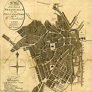
Plate 21: Map bounded by Flushing Avenue, Clinton Avenue, Myrtle Avenue, Cumberland

![]()
Wall Art and Photo Gifts from Liszt Collection
Plate 21: Map bounded by Flushing Avenue, Clinton Avenue, Myrtle Avenue, Cumberland
Plate 21: Map bounded by Flushing Avenue, Clinton Avenue, Myrtle Avenue, Cumberland Street. 1855, William Perris, Brooklyn, New York, N.Y. USA
Liszt Collection of nineteenth-century engravings and images to browse and enjoy
Media ID 12671145
© Quint Lox Limited
Brooklyn Cartographic Flushing Avenue Historic Map Map Bounded By Myrtle Avenue Plate 21 Vintage Map William Perris Clinton Avenue Old Map
FEATURES IN THESE COLLECTIONS
> Europe
> United Kingdom
> England
> Cumberland
> North America
> United States of America
> Maps
> North America
> United States of America
> New York
> New York
> Brooklyn
> Related Images
> North America
> United States of America
> New York
> New York
> Maps
EDITORS COMMENTS
This print showcases Plate 21 of a historic map of Brooklyn, New York, created by William Perris in 1855. The intricate details and precise cartography make it a valuable piece for geography enthusiasts and history buffs alike. The map is bounded by Flushing Avenue, Clinton Avenue, Myrtle Avenue, and Cumberland Street, offering a glimpse into the city's layout during that era. It serves as a fascinating time capsule of Brooklyn's past with its vintage charm and old-world aesthetics. As you explore this remarkable artwork, you can almost feel the bustling energy that once filled these streets. Each street name holds stories of countless footsteps taken by residents who lived their lives within these boundaries over a century ago. From an artistic perspective, the composition is visually striking with its delicate lines and meticulous attention to detail. Every corner reveals something new to discover – from architectural landmarks to natural features – painting a vivid picture of what life was like in this vibrant neighborhood back then. Whether you are an avid collector or simply appreciate historical artifacts, this print offers an opportunity to own a piece of American history. It allows us to connect with our roots while appreciating the craftsmanship involved in creating such intricate maps during those times
MADE IN THE USA
Safe Shipping with 30 Day Money Back Guarantee
FREE PERSONALISATION*
We are proud to offer a range of customisation features including Personalised Captions, Color Filters and Picture Zoom Tools
SECURE PAYMENTS
We happily accept a wide range of payment options so you can pay for the things you need in the way that is most convenient for you
* Options may vary by product and licensing agreement. Zoomed Pictures can be adjusted in the Cart.