Home > Europe > Albania > Maps
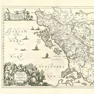
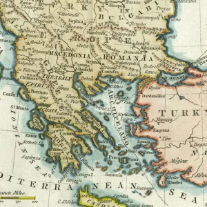
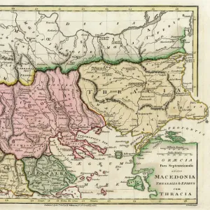
1752, Vaugondy Map of Greece, Macedonia and Albania, topography, cartography, geography

![]()
Wall Art and Photo Gifts from Liszt Collection
1752, Vaugondy Map of Greece, Macedonia and Albania, topography, cartography, geography
1752, Vaugondy Map of Greece, Macedonia and Albania
Liszt Collection of nineteenth-century engravings and images to browse and enjoy
Media ID 14004609
© Artokoloro Quint Lox Limited
1752 Antique Map Atlas Chart Geographic Latitude Longitude Mappa Mundi Old Antique Plan Old Antique View Old Map Ols Antique Map Rare Old Maps Topo
FEATURES IN THESE COLLECTIONS
> Maps and Charts
> Early Maps
> Maps and Charts
> North Macedonia
> Maps and Charts
> World
EDITORS COMMENTS
This print showcases the exquisite "1752, Vaugondy Map of Greece, Macedonia and Albania". A true masterpiece in cartography, this topographical representation offers a fascinating glimpse into the geography of these ancient lands. The intricate details and precision displayed on this vintage map are truly awe-inspiring. The carefully drawn lines depict latitude and longitude, creating a grid that allows for accurate navigation across the region. Every contour is meticulously illustrated to showcase the diverse landscapes found within Greece, Macedonia, and Albania. From majestic mountains to winding rivers and sprawling coastlines, this map captures it all. Steeped in history and rich with cultural significance, this old-world artifact takes us back in time to an era when exploration was at its peak. It serves as a reminder of our ancestors' thirst for knowledge about the world around them. Adorned with decorative elements that add charm to its overall aesthetic appeal, this antique map is not only a valuable historical document but also a work of art. Its aged appearance adds character while evoking nostalgia for times long gone. Whether you're an avid traveler or simply fascinated by ancient civilizations, this remarkable piece from the Liszt Collection will transport you on an extraordinary journey through time and space.
MADE IN THE USA
Safe Shipping with 30 Day Money Back Guarantee
FREE PERSONALISATION*
We are proud to offer a range of customisation features including Personalised Captions, Color Filters and Picture Zoom Tools
SECURE PAYMENTS
We happily accept a wide range of payment options so you can pay for the things you need in the way that is most convenient for you
* Options may vary by product and licensing agreement. Zoomed Pictures can be adjusted in the Cart.