Home > Europe > France > Canton > Landes
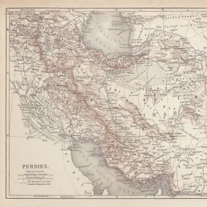
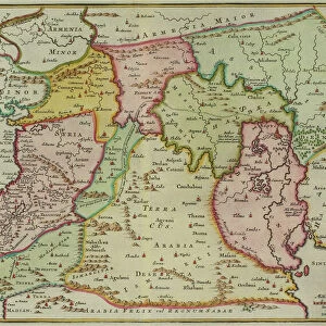
Photographic Print : 1720, Weigel Map of the Caucuses including Armenia, Georgia, and Azerbaijan, topography


![]()
Photo Prints from Liszt Collection
1720, Weigel Map of the Caucuses including Armenia, Georgia, and Azerbaijan, topography
1720, Weigel Map of the Caucuses including Armenia, Georgia, and Azerbaijan
Liszt Collection of nineteenth-century engravings and images to browse and enjoy
Media ID 14004497
© Artokoloro Quint Lox Limited
1720 Georgia Antique Map Atlas Chart Geographic Latitude Longitude Mappa Mundi Old Antique Plan Old Antique View Old Map Ols Antique Map Rare Old Maps Topo
14"x11" Photo Print
Discover the rich history and geography of the Caucasus region with our exquisite 1720 Weigel Map of Armenia, Georgia, and Azerbaijan from the renowned Liszt Collection. This rare and intricately detailed antique map showcases the topography of the Caucasus Mountains and the surrounding territories, offering a fascinating glimpse into the past. With its beautiful hand-drawn borders, vibrant colors, and meticulous labeling, this vintage map print makes a captivating addition to any home or office decor. Bring history to life and transport yourself to another era with our Media Storehouse range of high-quality photographic prints.
Photo prints are produced on Kodak professional photo paper resulting in timeless and breath-taking prints which are also ideal for framing. The colors produced are rich and vivid, with accurate blacks and pristine whites, resulting in prints that are truly timeless and magnificent. Whether you're looking to display your prints in your home, office, or gallery, our range of photographic prints are sure to impress. Dimensions refers to the size of the paper in inches.
Our Photo Prints are in a large range of sizes and are printed on Archival Quality Paper for excellent colour reproduction and longevity. They are ideal for framing (our Framed Prints use these) at a reasonable cost. Alternatives include cheaper Poster Prints and higher quality Fine Art Paper, the choice of which is largely dependant on your budget.
Estimated Product Size is 35.5cm x 27.9cm (14" x 11")
These are individually made so all sizes are approximate
Artwork printed orientated as per the preview above, with landscape (horizontal) or portrait (vertical) orientation to match the source image.
FEATURES IN THESE COLLECTIONS
> Asia
> Armenia
> Related Images
> Asia
> Azerbaijan
> Maps
> Asia
> Azerbaijan
> Related Images
> Asia
> Georgia
> Related Images
> Europe
> Armenia
> Related Images
> Europe
> France
> Canton
> Landes
EDITORS COMMENTS
This print showcases the exquisite 1720 Weigel Map of the Caucuses, offering a fascinating glimpse into the historical geography of Armenia, Georgia, and Azerbaijan. The intricate topography depicted on this map transports us back in time to an era when cartography was both an art form and a scientific endeavor. With its meticulous attention to detail, this vintage map provides a wealth of information about the landforms and geographic features that define this region. From mountain ranges to rivers, valleys to plateaus, every contour is meticulously illustrated with precision and skill. As we explore this ancient relic from history, we are reminded of the importance of navigation and discovery in shaping our understanding of the world. This map served as a vital tool for explorers seeking new territories or traders charting their routes through unfamiliar lands. The aged appearance adds an air of authenticity to this historic piece. Its yellowed paper texture evokes nostalgia for bygone eras while reminding us that knowledge is timeless. This decorative artwork not only serves as a window into our past but also stands as a testament to human curiosity and ingenuity. Whether you are an avid collector or simply fascinated by history's mysteries, this rare old map offers endless possibilities for exploration within its carefully drawn lines. Let your imagination soar as you embark on a journey through time with this remarkable piece from Liszt Collection's archives.
MADE IN THE USA
Safe Shipping with 30 Day Money Back Guarantee
FREE PERSONALISATION*
We are proud to offer a range of customisation features including Personalised Captions, Color Filters and Picture Zoom Tools
SECURE PAYMENTS
We happily accept a wide range of payment options so you can pay for the things you need in the way that is most convenient for you
* Options may vary by product and licensing agreement. Zoomed Pictures can be adjusted in the Cart.