Home > Europe > Montenegro > Maps
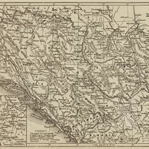
1690, Coronelli Map of Montenegro, topography, cartography, geography, land, illustration

![]()
Wall Art and Photo Gifts from Liszt Collection
1690, Coronelli Map of Montenegro, topography, cartography, geography, land, illustration
1690, Coronelli Map of Montenegro
Liszt Collection of nineteenth-century engravings and images to browse and enjoy
Media ID 14006564
© Artokoloro Quint Lox Limited
1690 Antique Map Atlas Chart Geographic Latitude Longitude Mappa Mundi Old Antique Plan Old Antique View Old Map Ols Antique Map Rare Old Maps Topo
FEATURES IN THESE COLLECTIONS
> Europe
> Montenegro
> Maps
> Maps and Charts
> Early Maps
> Maps and Charts
> Montenegro
> Maps and Charts
> World
EDITORS COMMENTS
This print showcases the exquisite 1690 Coronelli Map of Montenegro, a true masterpiece in cartography and geography. With its intricate topography and detailed illustrations, this ancient map takes us on a journey through time, offering a glimpse into the land's rich history and cultural heritage. The geometric precision of this vintage atlas is truly remarkable, as it meticulously charts the region's latitude and longitude coordinates with utmost accuracy. Its aged appearance adds to its charm, evoking a sense of nostalgia for bygone eras when paper maps were essential tools for navigation and exploration. As we gaze upon this historic artifact, we are transported back to an era where discovery was paramount. This rare old map not only serves as a window into the past but also ignites our curiosity about the world that existed centuries ago. With its decorative elements and artistic flair, this Coronelli Map of Montenegro is more than just a geographical representation; it is an embodiment of human ingenuity and fascination with our surroundings. It reminds us that even in today's digital age, there is still something enchanting about holding an antique map in our hands – connecting us to generations long gone while inspiring new adventures yet to come.
MADE IN THE USA
Safe Shipping with 30 Day Money Back Guarantee
FREE PERSONALISATION*
We are proud to offer a range of customisation features including Personalised Captions, Color Filters and Picture Zoom Tools
SECURE PAYMENTS
We happily accept a wide range of payment options so you can pay for the things you need in the way that is most convenient for you
* Options may vary by product and licensing agreement. Zoomed Pictures can be adjusted in the Cart.