Home > Europe > Ukraine > Maps
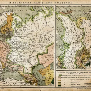
1574, Ruscelli Map of Russia, Muscovy and Ukraine, topography, cartography, geography

![]()
Wall Art and Photo Gifts from Liszt Collection
1574, Ruscelli Map of Russia, Muscovy and Ukraine, topography, cartography, geography
1574, Ruscelli Map of Russia, Muscovy and Ukraine
Liszt Collection of nineteenth-century engravings and images to browse and enjoy
Media ID 14004418
© Artokoloro Quint Lox Limited
1574 Antique Map Atlas Chart Geographic Latitude Longitude Mappa Mundi Old Antique Plan Old Antique View Old Map Ols Antique Map Rare Old Maps Topo
FEATURES IN THESE COLLECTIONS
> Maps and Charts
> Early Maps
> Maps and Charts
> World
EDITORS COMMENTS
This print showcases the remarkable 1574 Ruscelli Map of Russia, Muscovy, and Ukraine. A true masterpiece in cartography, this vintage map offers a glimpse into the rich history and topography of these regions. With its intricate details and precise illustrations, it serves as a testament to the artistry and skill of ancient mapmakers. The carefully plotted grid lines reveal latitude and longitude coordinates, allowing for accurate navigation across vast territories. The geometric precision employed in creating this map is truly awe-inspiring. Every contour, river, mountain range, and city is meticulously depicted with artistic flair. As we delve into this historical artifact, we embark on a journey through time—a discovery of lands long past. This rare old map not only provides valuable insights into geographical knowledge from centuries ago but also acts as a window to an era when exploration was at its peak. Printed on aged paper that exudes an air of antiquity, this decorative piece adds a touch of sophistication to any space it graces. Its presence evokes feelings of wonderment as we contemplate the vastness of our world throughout different epochs. Whether you are an avid collector or simply appreciate the beauty found in historical artifacts like maps, this stunning print transports you back in time while simultaneously celebrating the artistry behind early cartography.
MADE IN THE USA
Safe Shipping with 30 Day Money Back Guarantee
FREE PERSONALISATION*
We are proud to offer a range of customisation features including Personalised Captions, Color Filters and Picture Zoom Tools
SECURE PAYMENTS
We happily accept a wide range of payment options so you can pay for the things you need in the way that is most convenient for you
* Options may vary by product and licensing agreement. Zoomed Pictures can be adjusted in the Cart.