Home > Arts > Artists > K > Athanasius Kircher
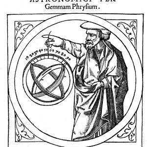
Use of the magnetic compass in map making, 1643

![]()
Wall Art and Photo Gifts from Heritage Images
Use of the magnetic compass in map making, 1643
Use of the magnetic compass in map making, 1643. Diagram of the use of the compass by cartographers and surveyors. Bor (Borealis) is north and Aust (Australis) is south. From Magnes: sive de arte magnetica by Athanasius Kircher. (Rome, 1643)
Heritage Images features heritage image collections
Media ID 14865934
© Oxford Science Archive / Heritage-Images
Arithmetic Athanasius Athanasius Kircher Athanasius Kirchner Cartography Compass Innovation Kircher Kirchner Athanasius Magnetic Magnetism Map Making Mathematics Maths Navigation Navigational Device North Oxford Science Archive Physics South Surveying World
FEATURES IN THESE COLLECTIONS
> Animals
> Mammals
> Cricetidae
> Australis
> Animals
> Mammals
> Delphinidae
> Australis
> Animals
> Mammals
> Molossidae
> Australis
> Arts
> Artists
> K
> Athanasius Kircher
> Europe
> Italy
> Lazio
> Rome
EDITORS COMMENTS
This print takes us back to the 17th century, showcasing the use of a magnetic compass in map making. The diagram depicted here is from Athanasius Kircher's renowned work "Magnes: sive de arte magnetica" published in Rome in 1643. It beautifully illustrates how cartographers and surveyors utilized this navigational device to determine directions on maps. Intriguingly, the woodcut diagram reveals that Bor (Borealis) represents north, while Aust (Australis) signifies south. This simple yet groundbreaking concept revolutionized map making during this era. The image captures the essence of innovation and technology merging with traditional cartography techniques. Kircher's work not only showcases his expertise in mathematics but also highlights his deep understanding of magnetism and its application to navigation. His contributions to science and physics are evident through this remarkable piece of art. As we gaze upon this monochrome print, we are transported into a world where exploration was at its peak, and accurate mapping was crucial for navigation across vast territories. This photograph serves as a reminder of the significant advancements made during the seventeenth century in terms of geographical knowledge and scientific discoveries. Preserved by Oxford Science Archive, this print allows us to appreciate Athanasius Kircher's legacy as an influential figure in both cartography and scientific research.
MADE IN THE USA
Safe Shipping with 30 Day Money Back Guarantee
FREE PERSONALISATION*
We are proud to offer a range of customisation features including Personalised Captions, Color Filters and Picture Zoom Tools
FREE COLORIZATION SERVICE
You can choose advanced AI Colorization for this picture at no extra charge!
SECURE PAYMENTS
We happily accept a wide range of payment options so you can pay for the things you need in the way that is most convenient for you
* Options may vary by product and licensing agreement. Zoomed Pictures can be adjusted in the Cart.