Home > Europe > United Kingdom > England > London > Art > Theatre
Route between Karaman and Kiz Kale, c1915. Creator: Stanfords Geographical Establishment

![]()
Wall Art and Photo Gifts from Heritage Images
Route between Karaman and Kiz Kale, c1915. Creator: Stanfords Geographical Establishment
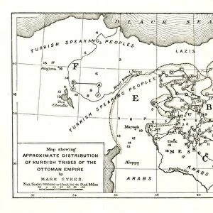
Route between Karaman and Kiz Kale, c1915. (Note Boyalar is about 8 miles S. of Karaman). Map showing the journey of British writer, soldier and diplomatic advisor Mark Sykes between Karaman (in Central Anatolia) and Kizkalesi on the coast of the Mediterranean in Turkey, (at that time part of the Ottoman Empire). Features marked include towers, lakes, temples, theatres, caves, ruins, aqueducts and castles. Sykes (1879-1919) travelled through Palestine, Iraq, Syria, Persia and Turkey between 1905 and 1913, was honorary attache to the British Embassy in Constantinople 1905-1906, was elected to parliament, worked in the Intelligence department of the War Office during the First World War, and died of the Spanish flu aged 39. From " The Caliphs Last Heritage, a short history of the Turkish Empire" by Lt.-Col. Sir Mark Sykes. [Macmillan & Co, London, 1915]
Heritage Images features heritage image collections
Media ID 19658891
© The Print Collector/Heritage Images
6th Baronet Altitude Anatolia Asia Minor Colonel Sir Tatton Benvenuto Mark Sykes Lieutenant Colonel Sir Mark Sykes Macmillan Macmillan And Co Macmillan Publishers Macmillan Publishers Ltd Mark Mark Sykes Ottoman Empire Publishers Macmillan Route Sir Mark Sykes Stanfords Stanfords Geographical Establishment Sykes Sykes Mark Sykes Mark Sir Sykes Tatton Benvenuto Mark Tatton Benvenuto Mark Tatton Benvenuto Mark Sykes Turkey Turkish
FEATURES IN THESE COLLECTIONS
> Architecture
> Towers
> Castles
> Asia
> Turkey
> Lakes
> Related Images
> Europe
> United Kingdom
> England
> London
> Art
> Theatre
EDITORS COMMENTS
This photo print, created by Stanfords Geographical Establishment in c1915, showcases the route between Karaman and Kiz Kale. The map depicts the journey of Mark Sykes, a British writer, soldier, and diplomatic advisor during his travels through Central Anatolia and the Ottoman Empire. The map is filled with intriguing features marked along the way. Towers, lakes, temples, theatres, caves, ruins, aqueducts, and castles dot this historical landscape. It provides a glimpse into the rich history and cultural heritage of this region. Mark Sykes was an extraordinary individual who explored Palestine, Iraq Syria Persia and Turkey between 1905 to 1913. He served as an honorary attache to the British Embassy in Constantinople from 1905 to 1906 before being elected to parliament. During World War I he worked in the Intelligence department of the War Office. Tragically though at just 39 years old he succumbed to Spanish flu. His contributions were not forgotten as his writings on Turkish history were published posthumously under "The Caliphs Last Heritage". This short history of the Turkish Empire sheds light on its past glory. This print takes us back in time to witness Sir Mark Sykes' adventurous journey through mountains and valleys while unraveling ancient wonders along his path. It serves as a testament to both his remarkable exploration skills and enduring legacy within academia.
MADE IN THE USA
Safe Shipping with 30 Day Money Back Guarantee
FREE PERSONALISATION*
We are proud to offer a range of customisation features including Personalised Captions, Color Filters and Picture Zoom Tools
SECURE PAYMENTS
We happily accept a wide range of payment options so you can pay for the things you need in the way that is most convenient for you
* Options may vary by product and licensing agreement. Zoomed Pictures can be adjusted in the Cart.