Home > Africa > Egypt > Maps
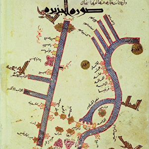
Rectangular world map (From: The Book of Curiosities of the Sciences and Marvels for the Eyes), 11th Artist: Anonymous master
, 11th Artist: Anonymous master")
![]()
Wall Art and Photo Gifts from Heritage Images
Rectangular world map (From: The Book of Curiosities of the Sciences and Marvels for the Eyes), 11th Artist: Anonymous master
Rectangular world map (From: The Book of Curiosities of the Sciences and Marvels for the Eyes), 11th century. Found in the collection of the Bodleian Library, Oxford
Heritage Images features heritage image collections
Media ID 15015604
© Fine Art Images
Anonymous Master Bodleian Library Cartography Ink On Parchment Oxford World Map
FEATURES IN THESE COLLECTIONS
> Arts
> Artists
> Related Images
EDITORS COMMENTS
This print showcases a rectangular world map from the 11th century, originating from "The Book of Curiosities of the Sciences and Marvels for the Eyes". Created by an anonymous master artist, this remarkable piece is now housed in the esteemed Bodleian Library in Oxford. The map itself is a testament to the artistry and skill of ancient cartographers, depicting a detailed representation of our planet during that era. Inked on parchment with precision and care, it offers a glimpse into how people perceived the world centuries ago. One cannot help but be drawn to its intricate details and fine craftsmanship. The lines tracing coastlines, rivers, and mountain ranges are delicately rendered, while cities are marked with tiny dots or symbols denoting their significance. This visual masterpiece serves as both an invaluable historical artifact and a work of art. Originating during the Fatimid Caliphate in Egypt, this map holds immense cultural significance as well. It provides insights into not only geographical knowledge but also political boundaries and trade routes prevalent at that time. As we gaze upon this extraordinary image captured through photography, we can appreciate its beauty while contemplating humanity's evolving understanding of our vast world throughout history.
MADE IN THE USA
Safe Shipping with 30 Day Money Back Guarantee
FREE PERSONALISATION*
We are proud to offer a range of customisation features including Personalised Captions, Color Filters and Picture Zoom Tools
SECURE PAYMENTS
We happily accept a wide range of payment options so you can pay for the things you need in the way that is most convenient for you
* Options may vary by product and licensing agreement. Zoomed Pictures can be adjusted in the Cart.