Home > Asia > Turkey > Related Images
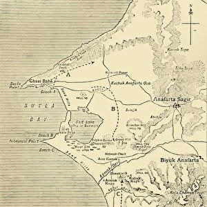
Map of the Gallipoli Peninsula, 1919. Creator: George Philip & Son Ltd

![]()
Wall Art and Photo Gifts from Heritage Images
Map of the Gallipoli Peninsula, 1919. Creator: George Philip & Son Ltd
Map of the Gallipoli Peninsula, 1919. The Gallipoli peninsula in western Turkey saw heavy fighting during the First World War, 1914-1919, with many casualties on both sides. Fortified towns, forts and batteries are indicated. From " The History of the Great European War: its causes and effects", Vol. IV, by W. Stanley Macbean Knight. [Caxton Pulishing Company, Limited, London, 1919]
Heritage Images features heritage image collections
Media ID 19047819
© The Print Collector/Heritage Images
Aegean Sea And Son Ltd Caxton Publishing Company Caxton Pulishing Company Caxton Pulishing Company Lim Caxton Pulishing Company Limited Caxton Pulishing Company Ltd Dardanelles Dardanelles Campaign Fort Forts Gallipoli Campaign Gallipoli Peninsula George Philip And Son George Philip And Son Ltd Hellespont Knight Limited Philip Stanley Macbean Stanley Macbean Knight Strait Turkey Turkish W Stanley Macbean W Stanley Macbean Knight William Stanley Macbean William Stanley Macbean Knight 1st World War
FEATURES IN THESE COLLECTIONS
> Asia
> Turkey
> Related Images
> Europe
> United Kingdom
> England
> London
> Related Images
EDITORS COMMENTS
This print captures a historical map of the Gallipoli Peninsula in 1919, created by George Philip & Son Ltd. The peninsula, located in western Turkey, was a significant battleground during the First World War from 1914 to 1919, resulting in heavy casualties on both sides. The map highlights fortified towns, forts, and batteries that played crucial roles during this intense conflict. Taken from "The History of the Great European War: its causes and effects". Volume IV by W. Stanley Macbean Knight, published by Caxton Publishing Company Limited in London in 1919, this print provides valuable insight into the geography and strategic features of the region at that time. The Gallipoli campaign was part of a larger effort to control access to the Dardanelles Strait and ultimately gain control over Constantinople (now Istanbul). This map serves as a reminder of the immense challenges faced by soldiers fighting along these treacherous coastal areas. With its monochrome aesthetic and detailed depiction of geographical features, this print transports us back to an era marked by war and turmoil. It is a testament to the bravery and sacrifice exhibited by those who fought on both sides during one of history's most devastating conflicts – World War I.
MADE IN THE USA
Safe Shipping with 30 Day Money Back Guarantee
FREE PERSONALISATION*
We are proud to offer a range of customisation features including Personalised Captions, Color Filters and Picture Zoom Tools
SECURE PAYMENTS
We happily accept a wide range of payment options so you can pay for the things you need in the way that is most convenient for you
* Options may vary by product and licensing agreement. Zoomed Pictures can be adjusted in the Cart.