Home > Europe > Sweden > Maps
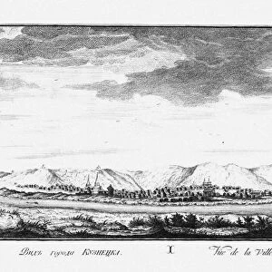
The Map of the First Kamchatka Expedition, 1725-1730. Artist: Bering, Vitus Jonassen (1681-1741)
")
![]()
Wall Art and Photo Gifts from Heritage Images
The Map of the First Kamchatka Expedition, 1725-1730. Artist: Bering, Vitus Jonassen (1681-1741)
The Map of the First Kamchatka Expedition, 1725-1730. Found in the collection of National Library of Sweden
Heritage Images features heritage image collections
Media ID 15006050
© Fine Art Images
Aleksei Chirikov Bering Cartography Chirikov Kamchatka Vitus Bering
FEATURES IN THESE COLLECTIONS
> Arts
> Artists
> Related Images
The Map of the First Kamchatka Expedition, 1725-1730
EDITORS COMMENTS
is a captivating print that takes us back in time to an era of exploration and discovery. Created by Vitus Jonassen Bering, a renowned Danish cartographer and explorer, this fine art piece showcases his meticulous attention to detail. The map depicts the route taken during the first Kamchatka expedition, led by Bering himself. It was during this groundbreaking journey that Bering discovered the strait that now bears his name - the Bering Strait. The map not only highlights this significant geographical finding but also provides valuable insights into the uncharted territories explored by him and his team. As we delve deeper into its intricate details, we can almost feel ourselves joining Bering on his perilous voyage across vast oceans and treacherous landscapes. The careful placement of landmarks and coastlines allows us to trace their path through unknown waters with awe-inspiring precision. This historical artifact serves as a testament to human curiosity and resilience in the face of adversity. It reminds us of our innate desire to explore new frontiers and expand our understanding of the world around us. Preserved within the National Library of Sweden's collection, "The Map of the First Kamchatka Expedition" stands as a tribute to Vitus Jonassen Bering's remarkable achievements and enduring legacy. Its presence invites us to embark on our own intellectual journey through history while admiring both its artistic beauty and scientific significance.
MADE IN THE USA
Safe Shipping with 30 Day Money Back Guarantee
FREE PERSONALISATION*
We are proud to offer a range of customisation features including Personalised Captions, Color Filters and Picture Zoom Tools
SECURE PAYMENTS
We happily accept a wide range of payment options so you can pay for the things you need in the way that is most convenient for you
* Options may vary by product and licensing agreement. Zoomed Pictures can be adjusted in the Cart.