Home > Animals > Mammals > Soricidae > Niger
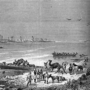
'Delta central ou region lacustre du Niger; L'Ouest Africain, 1914. Creator: Unknown

![]()
Wall Art and Photo Gifts from Heritage Images
'Delta central ou region lacustre du Niger; L'Ouest Africain, 1914. Creator: Unknown
'Delta central ou region lacustre du Niger; L'Ouest Africain, 1914. From "Grande Geographie Bong Illustree", 1914
Heritage Images features heritage image collections
Media ID 36295309
© The Print Collector/Heritage Images
Cartography Delta Lakes Mali Malian Map Making Mapmaking Niger River Niger West Africa West African Inland
FEATURES IN THESE COLLECTIONS
> Africa
> Mali
> Lakes
> Related Images
> Africa
> Mali
> Related Images
> Africa
> Niger
> Lakes
> Related Images
> Africa
> Niger
> Related Images
> Animals
> Mammals
> Soricidae
> Niger
> Europe
> France
> Lakes
> Related Images
EDITORS COMMENTS
This photograph print, titled 'Delta central ou region lacustre du Niger; L'Ouest Africain, 1914,' showcases the intricate and complex geography of the Niger Delta region in West Africa. The image, created in the 1910s, is an engraving taken from the renowned French geographical publication, 'Grande Geographie Bong Illustree,' published in 1914. The photograph reveals the vast network of waterways and lakes that make up the Niger Delta, a significant inland region located in present-day Mali and Nigeria. The Niger River, a major African waterway, is prominently featured, winding its way through the landscape and dividing the delta into distinct sections. The mapmaking of this era was crucial in understanding the geographical features of the region, which was largely unexplored by Europeans at the time. The print offers a glimpse into the colonial era of African cartography, with the French influence evident in the labeling and naming of various geographical features. The image is a testament to the historical significance of mapmaking and the role it played in shaping our understanding of the world. Despite being over a century old, the photograph remains an essential resource for scholars, historians, and anyone interested in the geography and history of West Africa. The creator of this photograph is unknown, but it is a reminder of the rich and complex history that lies within the pages of old maps and geographical publications. The photograph's intricate details and historical significance make it a valuable addition to any collection of African history, cartography, or geography.
MADE IN THE USA
Safe Shipping with 30 Day Money Back Guarantee
FREE PERSONALISATION*
We are proud to offer a range of customisation features including Personalised Captions, Color Filters and Picture Zoom Tools
SECURE PAYMENTS
We happily accept a wide range of payment options so you can pay for the things you need in the way that is most convenient for you
* Options may vary by product and licensing agreement. Zoomed Pictures can be adjusted in the Cart.