Home > North America > Guadeloupe > Maps
Photographic Print : Guadeloupe Map


![]()
Photo Prints from Mary Evans Picture Library
Guadeloupe Map
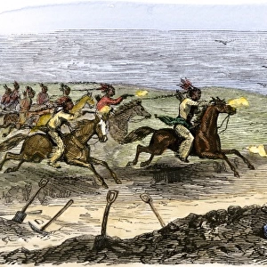
The two main islands, Guadeloupe and Grande Terre, are separated by a narrow channel : they were discovered by Columbus in 1493
Mary Evans Picture Library makes available wonderful images created for people to enjoy over the centuries
Media ID 4386855
© Mary Evans Picture Library 2015 - https://copyrighthub.org/s0/hub1/creation/maryevans/MaryEvansPictureID/10054712
1493 Channel Columbus Discovered Grande Guadeloupe Indies Main Maps Narrow Separated Terre
14"x11" Photo Print
Discover the enchanting beauty of Guadeloupe with our Media Storehouse Photographic Prints. This stunning image of the Guadeloupe Map by Rights Managed from Mary Evans Prints Online captures the essence of this Caribbean gem, with its two main islands, Guadeloupe and Grande Terre, gracefully separated by a narrow channel. Travel back in time with Columbus as you explore the rich history and natural wonders of this breathtaking destination. Bring this captivating print into your home or office to inspire your next adventure.
Photo prints are produced on Kodak professional photo paper resulting in timeless and breath-taking prints which are also ideal for framing. The colors produced are rich and vivid, with accurate blacks and pristine whites, resulting in prints that are truly timeless and magnificent. Whether you're looking to display your prints in your home, office, or gallery, our range of photographic prints are sure to impress. Dimensions refers to the size of the paper in inches.
Our Photo Prints are in a large range of sizes and are printed on Archival Quality Paper for excellent colour reproduction and longevity. They are ideal for framing (our Framed Prints use these) at a reasonable cost. Alternatives include cheaper Poster Prints and higher quality Fine Art Paper, the choice of which is largely dependant on your budget.
Estimated Product Size is 35.5cm x 27.9cm (14" x 11")
These are individually made so all sizes are approximate
Artwork printed orientated as per the preview above, with landscape (horizontal) orientation to match the source image.
FEATURES IN THESE COLLECTIONS
> Maps and Charts
> Early Maps
> North America
> Guadeloupe
> Maps
> North America
> Guadeloupe
> Related Images
EDITORS COMMENTS
This print of the Guadeloupe Map showcases the rich history and geographical significance of this stunning Caribbean destination. The map highlights the two main islands, Guadeloupe and Grande Terre, which are separated by a narrow channel. It is fascinating to learn that these islands were first discovered by Christopher Columbus in 1493 during his exploration of the West Indies.
The intricate details on this historical map provide a glimpse into the mid-19th century when cartography was at its peak. The careful delineation of the channels and coastlines demonstrates the precision and skill of mapmakers from that era.
As we admire this piece, we are transported back in time to an age of exploration and discovery. The vibrant colors and intricate lines tell a story of adventure and intrigue, inviting us to delve deeper into the history of these beautiful islands.
Whether you have a personal connection to Guadeloupe or simply appreciate historical maps, this print is sure to spark your curiosity and imagination. Display it proudly in your home or office as a conversation starter and a reminder of the rich tapestry of our world's past.
MADE IN THE USA
Safe Shipping with 30 Day Money Back Guarantee
FREE PERSONALISATION*
We are proud to offer a range of customisation features including Personalised Captions, Color Filters and Picture Zoom Tools
SECURE PAYMENTS
We happily accept a wide range of payment options so you can pay for the things you need in the way that is most convenient for you
* Options may vary by product and licensing agreement. Zoomed Pictures can be adjusted in the Cart.