Home > Arts > Artists > H > Jodocus Hondius
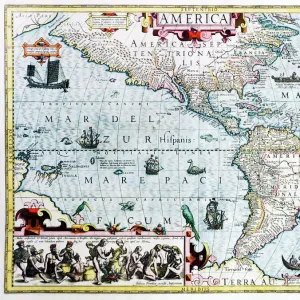
WEST AFRICAN MAP, 1606. Jodocus Hondiuss 1606 map of the West African coast from Senegal to Cape Lopez on the Gulf

![]()
Wall Art and Photo Gifts from Granger
WEST AFRICAN MAP, 1606. Jodocus Hondiuss 1606 map of the West African coast from Senegal to Cape Lopez on the Gulf
WEST AFRICAN MAP, 1606. Jodocus Hondiuss 1606 map of the West African coast from Senegal to Cape Lopez on the Gulf of Guinea
Granger holds millions of images spanning more than 25,000 years of world history, from before the Stone Age to the dawn of the Space Age
Media ID 6616635
1606 Hondius Jodocus West African Gulf Of Guinea
FEATURES IN THESE COLLECTIONS
> Arts
> Artists
> H
> Jodocus Hondius
> Arts
> Landscape paintings
> Waterfall and river artworks
> River artworks
> Granger Art on Demand
> Maps
> Maps and Charts
> Related Images
EDITORS COMMENTS
This print showcases the intricate details of Jodocus Hondiuss' 1606 map, depicting the West African coast from Senegal to Cape Lopez on the Gulf of Guinea. The map is a testament to Hondiuss' skill and precision as a cartographer during this era. The West African Map, created over four centuries ago, offers a fascinating glimpse into the exploration and navigation techniques employed by early European explorers. It serves as a historical document that sheds light on their understanding of geography at that time. Every line and contour on this map tells a story of adventure, discovery, and trade along the vibrant river systems that crisscrossed West Africa. From Senegal's bustling shores to Cape Lopez's tranquil beauty, each landmark is meticulously illustrated with artistic flair. As we gaze upon this remarkable piece of artistry, we are transported back in time to an era when maps were not only navigational tools but also works of art. This print allows us to appreciate both its aesthetic appeal and historical significance. Whether you are an avid historian or simply intrigued by ancient cartography, this print will undoubtedly captivate your imagination. Let it serve as a reminder of our shared human curiosity for exploration and our eternal quest for knowledge about distant lands beyond our own horizons.
MADE IN THE USA
Safe Shipping with 30 Day Money Back Guarantee
FREE PERSONALISATION*
We are proud to offer a range of customisation features including Personalised Captions, Color Filters and Picture Zoom Tools
SECURE PAYMENTS
We happily accept a wide range of payment options so you can pay for the things you need in the way that is most convenient for you
* Options may vary by product and licensing agreement. Zoomed Pictures can be adjusted in the Cart.