Home > Arts > Landscape paintings > Waterfall and river artworks > River artworks
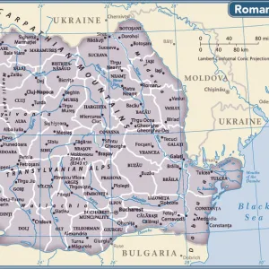
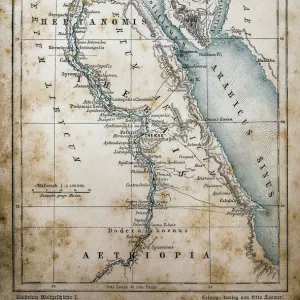
MAP: DANUBE. French map, 18th century, with instructions for navigating the Danube

![]()
Wall Art and Photo Gifts from Granger
MAP: DANUBE. French map, 18th century, with instructions for navigating the Danube
MAP: DANUBE.
French map, 18th century, with instructions for navigating the Danube River upstream from Orsova, Romania
Granger holds millions of images spanning more than 25,000 years of world history, from before the Stone Age to the dawn of the Space Age
Media ID 12319791
Aerial View Danube Handwriting Instruction Navigation Romania Serbia Orsova
FEATURES IN THESE COLLECTIONS
> Aerial Photography
> Romania
> Arts
> Landscape paintings
> Waterfall and river artworks
> River artworks
> Europe
> Romania
> Aerial Views
> Europe
> Serbia
> Aerial Views
> Granger Art on Demand
> Maps
EDITORS COMMENTS
This print from Granger Art on Demand showcases a remarkable piece of history - a French map of the Danube River dating back to the 18th century. The intricate details and exquisite craftsmanship of this map are truly awe-inspiring. The aerial view depicted in this print offers a unique perspective, allowing us to appreciate the vastness and beauty of the Danube River as it winds its way through various countries. With handwritten instructions for navigating the river upstream from Orsova, Romania, this map served as an invaluable tool for sailors and explorers during that era. As we examine this historical artifact closely, we can't help but marvel at the meticulous attention given to every detail. The delicate handwriting adds an authentic touch, reminding us of a time when maps were carefully crafted by hand. This stunning piece not only serves as a visual delight but also provides insight into maritime navigation techniques used centuries ago. It is fascinating to imagine how sailors relied on such maps to navigate their way along the mighty Danube River. Whether you have an interest in cartography or simply appreciate art that tells stories of our past, this French map print is sure to captivate your imagination. Add it to your collection today and let it transport you back in time to an era filled with exploration and adventure along one of Europe's most iconic rivers – the Danube.
MADE IN THE USA
Safe Shipping with 30 Day Money Back Guarantee
FREE PERSONALISATION*
We are proud to offer a range of customisation features including Personalised Captions, Color Filters and Picture Zoom Tools
SECURE PAYMENTS
We happily accept a wide range of payment options so you can pay for the things you need in the way that is most convenient for you
* Options may vary by product and licensing agreement. Zoomed Pictures can be adjusted in the Cart.