Home > Arts > Artists > H > Thomas Hood
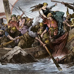
CHANNEL CHART, 1596. Detail of sailing chart of English Channel by Thomas Hood, 1596

![]()
Wall Art and Photo Gifts from Granger
CHANNEL CHART, 1596. Detail of sailing chart of English Channel by Thomas Hood, 1596
CHANNEL CHART, 1596.
Detail of sailing chart of English Channel by Thomas Hood, 1596
Granger holds millions of images spanning more than 25,000 years of world history, from before the Stone Age to the dawn of the Space Age
Media ID 12319658
1596 Channel Detail Hood Portolan Chart
FEATURES IN THESE COLLECTIONS
> Arts
> Artists
> H
> Thomas Hood
> Europe
> France
> Sport
> Sailing
> Europe
> United Kingdom
> England
> Maps
> Granger Art on Demand
> Maps
EDITORS COMMENTS
This print showcases a remarkable piece of history - the "CHANNEL CHART, 1596". It is a detailed sailing chart of the English Channel created by Thomas Hood during the Renaissance period. The intricate design and precision of this map are truly awe-inspiring. As we delve into this masterpiece, we are transported back to 16th century England. Every stroke on this chart represents countless hours spent meticulously mapping out ports, coastlines, and navigational routes. It serves as a testament to the skill and expertise possessed by cartographers like Hood. The English Channel, known for its strategic importance in maritime trade between England and France, takes center stage in this artwork. The chart not only provides an accurate depiction of the channel but also highlights various ports along both coasts. This attention to detail allows us to imagine bustling harbors filled with ships from different nations. Hood's work reflects the advancements made during the Renaissance era when exploration and navigation were at their peak. This map stands as a testament to human curiosity and determination to conquer uncharted territories. "CHANNEL CHART, 1596" is more than just a historical document; it is an exquisite piece of art that captures our imagination while reminding us of humanity's thirst for knowledge about our world's vast oceans.
MADE IN THE USA
Safe Shipping with 30 Day Money Back Guarantee
FREE PERSONALISATION*
We are proud to offer a range of customisation features including Personalised Captions, Color Filters and Picture Zoom Tools
SECURE PAYMENTS
We happily accept a wide range of payment options so you can pay for the things you need in the way that is most convenient for you
* Options may vary by product and licensing agreement. Zoomed Pictures can be adjusted in the Cart.