Home > Europe > United Kingdom > England > Maps
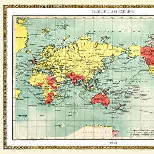
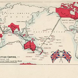
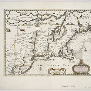
MAP: REVOLUTIONARY WAR, 1776. A map produced in London depicting the North American

![]()
Wall Art and Photo Gifts from Granger
MAP: REVOLUTIONARY WAR, 1776. A map produced in London depicting the North American
MAP: REVOLUTIONARY WAR, 1776. A map produced in London depicting the North American colonies involved in the war against Great Britain. Map, 1776
Granger holds millions of images spanning more than 25,000 years of world history, from before the Stone Age to the dawn of the Space Age
Media ID 13642952
1776 British Empire Canada Colonies East Great Britain London New England North America Revolutionary War
FEATURES IN THESE COLLECTIONS
> Europe
> United Kingdom
> England
> London
> Related Images
> Europe
> United Kingdom
> England
> Maps
> Maps and Charts
> British Empire Maps
> North America
> Canada
> Maps
EDITORS COMMENTS
This print transports us back to the year 1776, a time of great upheaval and transformation in North America. The map, produced in London, serves as a visual representation of the Revolutionary War that unfolded between the British Empire and its colonies across the Atlantic. With intricate details meticulously depicted on this historical artifact, it provides an invaluable insight into the geographical landscape of that period. The map showcases not only the thirteen colonies involved in their fight for independence but also highlights Canada and other territories under British control. Its significance lies not just in its cartographic accuracy but also in its ability to capture the spirit of rebellion and defiance that characterized this pivotal era. As we examine this piece closely, we are reminded of how maps were crucial tools used by both sides during wartime. They served as strategic guides for military campaigns while offering valuable information about territorial boundaries and resources. This particular map is a testament to London's role as a hub of knowledge dissemination during those times. Produced with meticulous attention to detail, it stands as a testament to human curiosity and exploration. In acquiring this print from Granger Art on Demand, we gain access to an extraordinary window into history—a tangible reminder of our collective past and an invitation to reflect upon the struggles endured by those who fought for freedom during one of humanity's most significant revolutions.
MADE IN THE USA
Safe Shipping with 30 Day Money Back Guarantee
FREE PERSONALISATION*
We are proud to offer a range of customisation features including Personalised Captions, Color Filters and Picture Zoom Tools
SECURE PAYMENTS
We happily accept a wide range of payment options so you can pay for the things you need in the way that is most convenient for you
* Options may vary by product and licensing agreement. Zoomed Pictures can be adjusted in the Cart.