Fraud Blocker Skip to main content

Uig Premium 1 Collection

"UIG Premium 1: A Captivating Journey through Time and Space" Step into the world of UIG Premium 1

Background imageUig Premium 1 Collection: Daltons table of Atomic symbols, 1835

Daltons table of Atomic symbols, 1835
John Dalton (1766-1844) English chemist. Daltons table of Atomic symbols from a lecture delivered by him at the Manchester Mechanics Institution, October 1835

Background imageUig Premium 1 Collection: Gustav Klimt 1862 - 1918. The Kis

Gustav Klimt 1862 - 1918. The Kis was painted by Gustav Klimt, and is probably his most famous work. He began work on it in 1907 and it is the highpoint of his so-called Golden Period

Background imageUig Premium 1 Collection: 917_05_014521. jpg Uig Premium 1 UIG1_HISTORY

917_05_014521. jpg Uig Premium 1 UIG1_HISTORY
917_05_014521.jpg, uig premium 1, UIG1_HISTORY, Universal History Archive batch1, Art, 917 05 014521

Background imageUig Premium 1 Collection: Globe North Pole, True Colour Satellite Image. Cloudless true colour satellite image of the Earth, c

Globe North Pole, True Colour Satellite Image. Cloudless true colour satellite image of the Earth, centred on the Arctic or north polar region

Background imageUig Premium 1 Collection: Asia At Night With Country Borders, True Colour Satellite Image

Asia At Night With Country Borders, True Colour Satellite Image. True colour satellite image of Asia at night with country borders

Background imageUig Premium 1 Collection: Globe Centred On Asia And Oceania, True Colour Satellite Image Of The Earth

Globe Centred On Asia And Oceania, True Colour Satellite Image Of The Earth
Globe Centred On Asia And Oceania, True Colour Satellite Image. True colour satellite image of the Earth centred on Asia and Oceania with cloud coverage, during summer solstice at 6 a.m GMT

Background imageUig Premium 1 Collection: Globe Showing Europe, True Colour Satellite Image Of The Earth Showing Greenland, North Pole, Europe

Globe Showing Europe, True Colour Satellite Image Of The Earth Showing Greenland, North Pole, Europe
Globe Showing Europe, True Colour Satellite Image. True colour satellite image of the Earth showing Greenland, the North Pole and Europe, with cloud coverage

Background imageUig Premium 1 Collection: Whole Earth At Night Centred On Pacific Ocean, True Colour Satellite Image Of The Earth

Whole Earth At Night Centred On Pacific Ocean, True Colour Satellite Image Of The Earth
Whole Earth At Night Centred On Pacific Ocean, True Colour Satellite Image. True colour satellite image of the whole Earth at night, centred on the Pacific Ocean, with country borders

Background imageUig Premium 1 Collection: Whole Earth Centred On Pacific Ocean, True Colour Satellite Image Of The Earth

Whole Earth Centred On Pacific Ocean, True Colour Satellite Image Of The Earth
Whole Earth Centred On Pacific Ocean, True Colour Satellite Image. True colour satellite image of the whole Earth centred on the Pacific Ocean, with bump effect

Background imageUig Premium 1 Collection: Globe Showing Europe And Africa, True Colour Satellite Image Of The Earth

Globe Showing Europe And Africa, True Colour Satellite Image Of The Earth
Globe Showing Europe And Africa, True Colour Satellite Image. True colour satellite image of the Earth showing Europe and Africa, half in shadow, and the sun

Background imageUig Premium 1 Collection: Globe Asia, True Colour Satellite Image. Earth. True colour satellite image of the Earth, centred

Globe Asia, True Colour Satellite Image. Earth. True colour satellite image of the Earth, centred on Asia. The North Pole is at upper centre

Background imageUig Premium 1 Collection: Africa At Night With Country Borders, True Colour Satellite Image

Africa At Night With Country Borders, True Colour Satellite Image. True colour satellite image of Africa at night with country borders

Background imageUig Premium 1 Collection: Globe Europe, True Colour Satellite Image. True colour satellite image of the whole earth, showing E

Globe Europe, True Colour Satellite Image. True colour satellite image of the whole earth, showing Europe at centre. The picture is a composite created from thousands of separate images recorded by

Background imageUig Premium 1 Collection: Globe Centred On Europe And Africa, True Colour Satellite Image Of The Earth

Globe Centred On Europe And Africa, True Colour Satellite Image Of The Earth
Globe Centred On Europe And Africa, True Colour Satellite Image. True colour satellite image of the Earth centred on Europe and Africa with cloud coverage, during summer solstice at 12 a.m GMT

Background imageUig Premium 1 Collection: Europe At Night With Cloud Coverage, True Colour Satellite Image

Europe At Night With Cloud Coverage, True Colour Satellite Image. True colour satellite image of Europe at night with cloud coverage

Background imageUig Premium 1 Collection: Globe Oceania, True Colour Satellite Image. Earth. True colour satellite image of the Earth, centred

Globe Oceania, True Colour Satellite Image. Earth. True colour satellite image of the Earth, centred on the region of Oceania. North is at top

Background imageUig Premium 1 Collection: Europe At Night, True Colour Satellite Image. True colour satellite image of Europe at night

Europe At Night, True Colour Satellite Image. True colour satellite image of Europe at night. This image in Lambert Conformal Conic projection was compiled from data acquired by LANDSAT 5 & 7

Background imageUig Premium 1 Collection: Desert Erg Iguidi, Algeria, True Colour Satellite Image. True colour satellite image of Erg Iguidi

Desert Erg Iguidi, Algeria, True Colour Satellite Image. True colour satellite image of Erg Iguidi, a sand desert between Algeria and Mauritania

Background imageUig Premium 1 Collection: City Of Harbin, Mandchouria, China, True Colour Satellite Image

City Of Harbin, Mandchouria, China, True Colour Satellite Image. The city of Harbin and surroundings covered by snow. The river Songhua that crosses the picture is frozen

Background imageUig Premium 1 Collection: Globe South America, True Colour Satellite Image. Earth. True colour satellite image of the Earth, c

Globe South America, True Colour Satellite Image. Earth. True colour satellite image of the Earth, centred on South America. North is at top

Background imageUig Premium 1 Collection: Lake Yamma, Queensland, Australia, True Colour Satellite Image

Lake Yamma, Queensland, Australia, True Colour Satellite Image. The Lake Yamma is a salted lake located in a semi-arid area. The lake evaporates totally during the dry season

Background imageUig Premium 1 Collection: Betsiboka River, Madagascar, True Colour Satellite Image. Betsiboka river

Betsiboka River, Madagascar, True Colour Satellite Image. Betsiboka river, the major river of Madagascar, goes into the Mozambique canal, close to the city of Mahajanga

Background imageUig Premium 1 Collection: Bissagos Archipelago, Guinea-Bissau, True Colour Satellite Image

Bissagos Archipelago, Guinea-Bissau, True Colour Satellite Image. True colour satellite image of Guinea-Bissau, a small country in West Africa

Background imageUig Premium 1 Collection: Western Europe At Night, Satellite Image. Lights of Western Europe at night from space. Coloured ima

Western Europe At Night, Satellite Image. Lights of Western Europe at night from space. Coloured image derived from satellite data showing Western Europe at night

Background imageUig Premium 1 Collection: Globe Centred On The Americas, True Colour Satellite Image. True colour satellite image of

Globe Centred On The Americas, True Colour Satellite Image. True colour satellite image of the Earth centred on the Americas with cloud coverage, during summer solstice at 6 a.m GMT

Background imageUig Premium 1 Collection: Libyan Desert, Egypt, True Colour Satellite Image. True colour satellite image of the Egyptian

Libyan Desert, Egypt, True Colour Satellite Image. True colour satellite image of the Egyptian part of the Libyan desert, made of both sand and rock; sand dunes are stretched out by the winds

Background imageUig Premium 1 Collection: Globe Africa, True Colour Satellite Image. Earth. True colour satellite image of the Earth, centred

Globe Africa, True Colour Satellite Image. Earth. True colour satellite image of the Earth, centred on Africa. North is at top

Background imageUig Premium 1 Collection: Globe Showing Asia, True Colour Satellite Image Of The Earth Showing Asia, Oceania And The Sun

Globe Showing Asia, True Colour Satellite Image Of The Earth Showing Asia, Oceania And The Sun
Globe Showing Asia, True Colour Satellite Image. True colour satellite image of the Earth showing Asia and Oceania, half in shadow, and the sun

Background imageUig Premium 1 Collection: Globe Showing Northern America, True Colour Satellite Image Of The Earth

Globe Showing Northern America, True Colour Satellite Image Of The Earth
Globe Showing Northern America, True Colour Satellite Image. True colour satellite image of the Earth showing Greenland, the North Pole and Northern America

Background imageUig Premium 1 Collection: Globe Showing The Americas, True Colour Satellite Image Of The Earth, Half In Shadow And The Sun

Globe Showing The Americas, True Colour Satellite Image Of The Earth, Half In Shadow And The Sun
Globe Showing The Americas, True Colour Satellite Image. True colour satellite image of the Earth showing the Americas, half in shadow, and the sun

Background imageUig Premium 1 Collection: Globe Showing Europe And Northern Africa, True Colour Satellite Image Of The Earth

Globe Showing Europe And Northern Africa, True Colour Satellite Image Of The Earth
Globe Showing Europe And Northern Africa, True Colour Satellite Image. True colour satellite image of the Earth showing Europe and Northern Africa, with cloud coverage

Background imageUig Premium 1 Collection: Globe Centred On The South Pole, True Colour Satellite Image Of The Earth

Globe Centred On The South Pole, True Colour Satellite Image Of The Earth
Globe Centred On The South Pole, True Colour Satellite Image. True colour satellite image of the Earth centred on the South Pole with cloud coverage, during summer solstice at 12 a.m GMT

Background imageUig Premium 1 Collection: North America At Night, True Colour Satellite Image. True colour satellite image of North America

North America At Night, True Colour Satellite Image. True colour satellite image of North America at night. This image in Lambert Conformal Conic projection was compiled from data acquired by LANDSAT

Background imageUig Premium 1 Collection: Whole Earth At Night With Cloud Coverage, True Colour Satellite Image

Whole Earth At Night With Cloud Coverage, True Colour Satellite Image. True colour satellite image of the whole Earth at night with cloud coverage

Background imageUig Premium 1 Collection: Everglades, Florida, Usa, True Colour Satellite Image. Satellite image of the Everglades

Everglades, Florida, Usa, True Colour Satellite Image. Satellite image of the Everglades. At the top of the image is the edge of the city of Miami

Background imageUig Premium 1 Collection: Rub Al Khali Desert, Saudi Arabia, True Colour Satellite Image. Rub Al Khali

Rub Al Khali Desert, Saudi Arabia, True Colour Satellite Image. Rub Al Khali, a sand desert South East of Saudi Arabia; sand dunes are sculptured and moved by the winds

Background imageUig Premium 1 Collection: Simpson Desert, Australia, True Colour Satellite Image. True colour satellite image of the Simpson

Simpson Desert, Australia, True Colour Satellite Image. True colour satellite image of the Simpson Desert in the Australian Outback. The sand dunes are coloured in red because of iron oxyd

Background imageUig Premium 1 Collection: Mississippi River Delta, Louisiana, Usa, True Colour Satellite Image

Mississippi River Delta, Louisiana, Usa, True Colour Satellite Image. True colour satellite image of the Mississippi River Delta

Background imageUig Premium 1 Collection: Agriculture, Texas, Usa, True Colour Satellite Image. True colour satellite image of center-pivot

Agriculture, Texas, Usa, True Colour Satellite Image. True colour satellite image of center-pivot irrigated fields in Texas, USA. Image taken on 21 September 1993 using LANDSAT data

Background imageUig Premium 1 Collection: Globe North America, True Colour Satellite Image. Earth. True colour satellite image of the Earth, c

Globe North America, True Colour Satellite Image. Earth. True colour satellite image of the Earth, centred on North America. The North Pole is at upper centre

Background imageUig Premium 1 Collection: over of Las Obras by Boscan Juan BoscA

over of Las Obras by Boscan Juan BoscA

Background imageUig Premium 1 Collection: hadow clock (gnomon) to 1400-1350 BC. JC Wood

hadow clock (gnomon) to 1400-1350 BC. JC Wood

Background imageUig Premium 1 Collection: Velasquez (1599-1660) The Reduction of Breda : Spanish occupation of Low Countries, 1625

Velasquez (1599-1660) The Reduction of Breda : Spanish occupation of Low Countries, 1625. Prado, Madrid

Background imageUig Premium 1 Collection: Industrialisation c1925. Factory chimneys pouring out polluted smoke - Sheffield

Industrialisation c1925. Factory chimneys pouring out polluted smoke - Sheffield. Illustration

Background imageUig Premium 1 Collection: The Vision of Saint Bernard 1650 AD by Alonso Cano, 1601-67, Spanish baroque painter

The Vision of Saint Bernard 1650 AD by Alonso Cano, 1601-67, Spanish baroque painter. Bernard of Clairvaux, (1090 -1153) was a Frankish abbot and the founder of the Cistercian monastic order

Background imageUig Premium 1 Collection: ope Paul IV, C. R. (28 June 1476 - 18 August 1559), Pope from 23 May 1555 until his death

ope Paul IV, C. R. (28 June 1476 - 18 August 1559), Pope from 23 May 1555 until his death
ope Paul IV, C.R. (28 June 1476 - 18 August 1559), Pope from 23 May 1555 until his death

Background imageUig Premium 1 Collection: 917_05_0510000804. jpg Uig Premium 1 UIG1_HISTORY

917_05_0510000804. jpg Uig Premium 1 UIG1_HISTORY
917_05_0510000804.jpg, uig premium 1, UIG1_HISTORY, Universal History Archive batch1, Art, 917 05 0510000804

Background imageUig Premium 1 Collection: 917_05_0510000786. jpg Uig Premium 1 UIG1_HISTORY

917_05_0510000786. jpg Uig Premium 1 UIG1_HISTORY
917_05_0510000786.jpg, uig premium 1, UIG1_HISTORY, Universal History Archive batch1, Art, 917 05 0510000786


All Professionally Made to Order for Quick Shipping

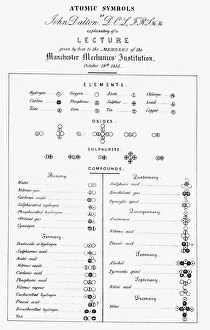
"UIG Premium 1: A Captivating Journey through Time and Space" Step into the world of UIG Premium 1, where history and exploration intertwine to create a captivating experience. Inspired by Dalton's Table of Atomic Symbols from 1835, this collection takes you on a visual voyage like no other. Immerse yourself in the artistic brilliance of Gustav Klimt, as his masterpiece "The Kiss" transports you to an era filled with passion and emotion. Feel the power of his brushstrokes as they come alive in vibrant hues. Delve deeper into the mysteries of our planet with true-color satellite images that showcase its breathtaking beauty. From Asia at night with country borders illuminated under Lambert Azimuthal Equal Area projection, compiled from data acquired by LANDSAT 5 & 7 satellites; to Europe's enchanting landscapes captured in all their glory; or even Africa at night revealing its intricate borders - each image tells a unique story. Witness Earth's majesty unfold before your eyes as you explore whole continents centered on the Pacific Ocean. Marvel at Greenland's icy expanse, North Pole's enigmatic allure, or Europe and Africa united in one striking view. Let these satellite images ignite your curiosity about our vast world. UIG Premium 1 invites you to embark on an extraordinary journey through time and space. Discover hidden wonders, unravel historical secrets, and immerse yourself in the sheer magnificence of our planet. Get ready for an adventure unlike any other.