Fraud Blocker Skip to main content

The World Collection

Background imageThe World Collection: Old Map of the World 1945

Old Map of the World 1945
WMY1945

Background imageThe World Collection: Old Map of the World 1980

Old Map of the World 1980
WMY1980

Background imageThe World Collection: Old Map of the World 1963

Old Map of the World 1963
WMY1963

Background imageThe World Collection: Old Map of the World 1988

Old Map of the World 1988
WMY1988

Background imageThe World Collection: Old Map of the World 1914

Old Map of the World 1914
WMY1914

Background imageThe World Collection: Old Map of the World 1966

Old Map of the World 1966
WMY1966

Background imageThe World Collection: Old Map of the World on Mercators Projection 1851 Showing the Voyages of Captain Cook by John Tallis

Old Map of the World on Mercators Projection 1851 Showing the Voyages of Captain Cook by John Tallis
A fine facimile artworked from an antique original map of The World on Mercators Projection Showing the Voyages of Capatain Cook

Background imageThe World Collection: Old Map of The World 1881

Old Map of The World 1881
Irish Land War (1879-1882); home rule movement led by Parnell. End of First Boer War (1880-1881). French establish a protectorate in Tunisia

Background imageThe World Collection: Old Map of the World 1982

Old Map of the World 1982
WMY1982

Background imageThe World Collection: Blue map of USA and the Caribbean sea

Blue map of USA and the Caribbean sea
Rosana Laiz Blursbyai

Background imageThe World Collection: Gallivanting

Gallivanting
Rosana Laiz Blursbyai

Background imageThe World Collection: Old Map of the World 1940

Old Map of the World 1940
WMY1940

Background imageThe World Collection: Old Map of the World 1958

Old Map of the World 1958
WMY1958

Background imageThe World Collection: Colorful map of the United States with States and State capitals

Colorful map of the United States with States and State capitals
Rosana Laiz Blursbyai

Background imageThe World Collection: Old Map of the World 1950

Old Map of the World 1950
WMY1950

Background imageThe World Collection: Old Map of the World 1973

Old Map of the World 1973
WMY1973

Background imageThe World Collection: AJAXNETPHOTO. 1989. SOLENT, ENGLAND

AJAXNETPHOTO. 1989. SOLENT, ENGLAND. FASTNET RACE - FAZISI OFF THE NEEDLES. RUSSIAN YACHT IS A WHITBREAD RACE ENTRY. 
PHOTO:JONATHAN EASTLAND /AJAX 
 REF:FAZISI 1989 02 AJAXNETPHOTO. 1989

Background imageThe World Collection: 1950s SPECIAL EFFECT NUCLEAR FAMILY MAN WOMAN BOY GIRL MOM DAD TWO KIDS STAND ON TOP OF WORLD

1950s SPECIAL EFFECT NUCLEAR FAMILY MAN WOMAN BOY GIRL MOM DAD TWO KIDS STAND ON TOP OF WORLD

Background imageThe World Collection: Map of the Earth (43-44 AD) after the Roman geographer and cosmographer Pomponius Mela

Map of the Earth (43-44 AD) after the Roman geographer and cosmographer Pomponius Mela, historical map of the world, illustration from 1881

Background imageThe World Collection: Abode of the antediluvian people

Abode of the antediluvian people, map of the earth after Kosmas Indicopleustes, late antique writer and traveller, historical map of the world, illustration from 1881

Background imageThe World Collection: Aerial view of artificial World island in Dubai. Panoramic view

Aerial view of artificial World island in Dubai. Panoramic view

Background imageThe World Collection: Aerial view from small airplane window, artificial palm island in Dubai. Panoramic view

Aerial view from small airplane window, artificial palm island in Dubai. Panoramic view

Background imageThe World Collection: Old Map of the World 1939

Old Map of the World 1939
WMY1939

Background imageThe World Collection: Old Map of the World 1970

Old Map of the World 1970
WMY1970

Background imageThe World Collection: Old Map of the World 1965

Old Map of the World 1965
WMY1965

Background imageThe World Collection: Old Map of the World 1908

Old Map of the World 1908
WMY1908

Background imageThe World Collection: Old Map of the World 1871

Old Map of the World 1871
THE WORLD THAT WAS 1871 - End of Franco-Prussian War; Germany unified, and Empire formed; Third Republic in France; suppression of the Paris Commune. British Columbia joins Canada. Chicago fires

Background imageThe World Collection: Old Map of The World 1879

Old Map of The World 1879
THE WORLD THAT WAS 1878 - Irish Land War (1879-1882). Second Afghan War gives Britain control over Afghanistan. Dual Alliance between Germany and Austria-Hungary. Anglo-Zulu War

Background imageThe World Collection: Old Map of the World 1893

Old Map of the World 1893
WMY1893

Background imageThe World Collection: Old Map of the World 1896

Old Map of the World 1896
WMY1896

Background imageThe World Collection: Old Map of the World 1981

Old Map of the World 1981
WMY1981

Background imageThe World Collection: Old Map of The World 1864

Old Map of The World 1864
THE WORLD THAT WAS 1864 - American Civil War (1861-1865). Prussia defeats Denmark. Russia suppresses Polish revolt. Taiping Rebellion in China (1851-1864), the second most destructive war in history

Background imageThe World Collection: Old Map of the World 1959

Old Map of the World 1959
WMY1959

Background imageThe World Collection: Old Map of the World 1906

Old Map of the World 1906
WMY1906

Background imageThe World Collection: Old Map of the World 1900

Old Map of the World 1900
WMY1900

Background imageThe World Collection: Old Map of the World 1875

Old Map of the World 1875
THE WORLD THAT WAS 1875 - Britain under Disraeli buys the Suez Canal to protect the sea route to India. USA expands settlement into Oregon. Egyptian invasion of Ethiopia

Background imageThe World Collection: Map of The British Empire by Fullarton & Co 1850

Map of The British Empire by Fullarton & Co 1850
Fine reproduction of the attractive World Map showing the British Empire

Background imageThe World Collection: 2008 Toyota Prius hybrid car, 2nd generation

2008 Toyota Prius hybrid car, 2nd generation

Background imageThe World Collection: Der Himmel uber Berlin Year : 1987 West Germany Director : Wim Wenders Bruno Ganz

Der Himmel uber Berlin Year : 1987 West Germany Director : Wim Wenders Bruno Ganz

Background imageThe World Collection: Guyart des Moulins, Bible historiale (Bible hystoriaulx), c.1415 (manuscript)

Guyart des Moulins, Bible historiale (Bible hystoriaulx), c.1415 (manuscript)
BL7210301 Guyart des Moulins, Bible historiale (Bible hystoriaulx), c.1415 (manuscript) by French School, (15th century); 45 x 33 cm; British Library, London

Background imageThe World Collection: The World, from The Key to the Tarot: being fragments of a secret tradition under the veil of divination

The World, from The Key to the Tarot: being fragments of a secret tradition under the veil of divination
BL5894894 The World, from The Key to the Tarot: being fragments of a secret tradition under the veil of divination

Background imageThe World Collection: The Assumption of the Virgin, 1498 (tempera on canvas)

The Assumption of the Virgin, 1498 (tempera on canvas)
8008598 The Assumption of the Virgin, 1498 (tempera on canvas) by Benvenuto di Giovanni

Background imageThe World Collection: Earth's Major Biomes, Map

Earth's Major Biomes, Map Map of Earth's major global biomes, including tundra, boreal, temperate, mediterranean, desert, tropical, and ice

Background imageThe World Collection: Black and White Illustrated Animal World Map by Carla Daly

Black and White Illustrated Animal World Map by Carla Daly
Carla Daly

Background imageThe World Collection: Old Map of the World 1957

Old Map of the World 1957
WMY1957

Background imageThe World Collection: Old Map of the World 1942

Old Map of the World 1942
WMY1942

Background imageThe World Collection: Old Map of the World 1951

Old Map of the World 1951
WMY1951

Background imageThe World Collection: Old Map of the World 1931

Old Map of the World 1931
WMY1931

Background imageThe World Collection: Inscription in South Pacific Ocean, c

Inscription in South Pacific Ocean, c
7339587 Inscription in South Pacific Ocean, c.1725 (papier mache, plaster, copper plate engraved, varnish, brass, wood, paper, hand-coloured) by Valk

Background imageThe World Collection: Cartouche in North Pacific Ocean, c.1880 (printed silk, metal, cotton)

Cartouche in North Pacific Ocean, c.1880 (printed silk, metal, cotton)
7339253 Cartouche in North Pacific Ocean, c.1880 (printed silk, metal, cotton) by Betts, John (19th century); 8x8 cm; National Maritime Museum, London

Background imageThe World Collection: Diagram of Meteorology, displaying the various phenomena of the atmosphere

Diagram of Meteorology, displaying the various phenomena of the atmosphere
7340562 Diagram of Meteorology, displaying the various phenomena of the atmosphere, 1846-60 (engraving) by Reynolds, James (fl.c.1846-60) & Emslie

Background imageThe World Collection: Explore world map with cities, Valrie

Explore world map with cities, Valrie
Rosana Laiz Blursbyai

Background imageThe World Collection: Watercolor world map with cities, Uyen

Watercolor world map with cities, Uyen
Rosana Laiz Blursbyai

Background imageThe World Collection: Watercolor world map with cities, Gina

Watercolor world map with cities, Gina
Rosana Laiz Blursbyai

Background imageThe World Collection: Watercolor world map with cities, Keahi

Watercolor world map with cities, Keahi
Rosana Laiz Blursbyai

Background imageThe World Collection: Watercolor world map with cities, Zadie

Watercolor world map with cities, Zadie
Rosana Laiz Blursbyai

Background imageThe World Collection: World map with outlined countries, Jacq

World map with outlined countries, Jacq
Rosana Laiz Blursbyai

Background imageThe World Collection: Terrestrial table globe, 1845 (cardboard)

Terrestrial table globe, 1845 (cardboard)
7342402 Terrestrial table globe, 1845 (cardboard, plaster, paper, varnish, brass, wood, hand-coloured, copper plate engraved, iron) by Malby (fl.1869); 46x30.5 cm; National Maritime Museum, London

Background imageThe World Collection: Cartouche in North Pacific Ocean, c

Cartouche in North Pacific Ocean, c
7339257 Cartouche in North Pacific Ocean, c.1795 (papier mache, copper plate engraved, brass, wood, paper) by Bardin, William (18th century); 40x44x30.4 cm; National Maritime Museum, London

Background imageThe World Collection: Pacific-centered world map with cities, Piper

Pacific-centered world map with cities, Piper
Rosana Laiz Blursbyai

Background imageThe World Collection: Watercolor world map with countries, Fifi

Watercolor world map with countries, Fifi
Rosana Laiz Blursbyai

Background imageThe World Collection: Classic world map in watercolor, Piper

Classic world map in watercolor, Piper
Rosana Laiz Blursbyai

Background imageThe World Collection: Lucille, map of the United States and the Caribbean sea

Lucille, map of the United States and the Caribbean sea
Rosana Laiz Blursbyai

Background imageThe World Collection: Adventure map of North America in cobalt blue

Adventure map of North America in cobalt blue
Rosana Laiz Blursbyai

Background imageThe World Collection: Map of North America in aquamarine watercolor

Map of North America in aquamarine watercolor
Rosana Laiz Blursbyai

Background imageThe World Collection: Pacific-centered world map with cities, Abey

Pacific-centered world map with cities, Abey
Rosana Laiz Blursbyai

Background imageThe World Collection: Watercolor world map with countries, Leo

Watercolor world map with countries, Leo
Rosana Laiz Blursbyai

Background imageThe World Collection: Watercolor world map with countries, Abey

Watercolor world map with countries, Abey
Rosana Laiz Blursbyai

Background imageThe World Collection: Classic world map in watercolor, Therese

Classic world map in watercolor, Therese
Rosana Laiz Blursbyai


All products are expertly crafted, using premium materials, tailored to your specifications and promptly shipped


EDITORS COMMENTS

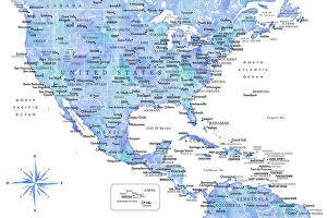
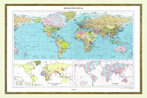
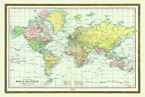
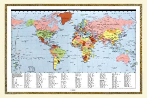
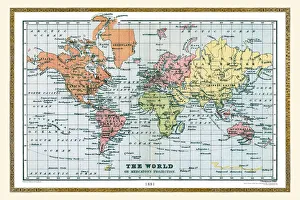
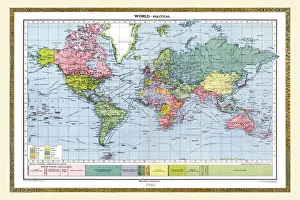
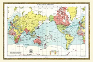
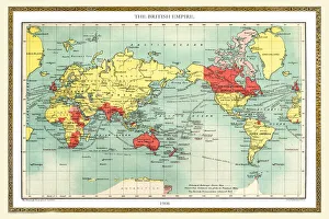
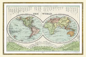
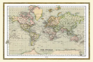
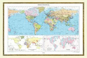
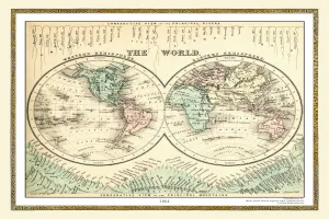
Exploring the vast tapestry of our world through the lens of time, these vintage maps take us on a captivating journey. The Old Map from 1980 reveals a snapshot of nations and boundaries that have since evolved, reminding us of the ever-changing nature of our global landscape. Delving further back to 1914, we witness an era marked by geopolitical tensions and impending conflict, as depicted in the Old Map from that year. Traveling even deeper into history, we encounter an enchanting glimpse into 1881 with its intricate details showcasing uncharted territories waiting to be discovered. The Old Map from 1963 unveils a world amidst Cold War rivalries and space exploration aspirations. The Mercator's Projection map from 1851 showcases Captain Cook's voyages, inviting us to embark on his daring expeditions across uncharted waters. A testament to post-war reformation emerges in the form of an evocative Old Map from 1945 - capturing both hope for rebuilding shattered societies and lingering scars left behind. Intriguingly designed maps like Vorfreude or Fernweh evoke wanderlust within us – beckoning adventurers to gallivant across continents in search of new experiences. Blue strokes or gray strokes painted upon these cartographic masterpieces add depth and character while Solivagant whispers tales about solitary souls wandering through unknown realms. These antique maps remind us that our world is not merely lines etched onto paper but rather a living entity brimming with stories yet untold. They ignite curiosity within our hearts, urging us to explore beyond familiar horizons and embrace all that this magnificent planet has to offer.

© Copyright Media Storehouse, All Rights Reserved 2003 - 2025
Facebook     Pinterest     100% Payment Secure     Reviews IO