
Rivington Street Collection
Rivington Street: A Cultural Melting Pot in the Heart of London Located in the vibrant borough of Hackney


All Professionally Made to Order for Quick Shipping
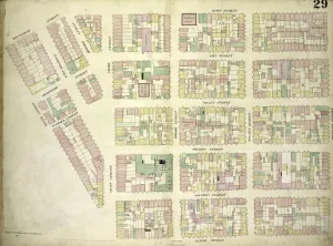
Rivington Street: A Cultural Melting Pot in the Heart of London Located in the vibrant borough of Hackney, a bustling thoroughfare that encapsulates the essence of urban life. This iconic street stretches across several neighborhoods, connecting St. Helens, Oldham, Rochdale, Wigan, and Bolton. As you wander along Rivington Street, you'll find yourself immersed in a tapestry of cultures and experiences. From its humble beginnings as an industrial hub to its current status as a trendy hotspot for creatives and entrepreneurs alike, this street has seen it all. The history embedded within Rivington Street's cobblestone pavements tells tales of resilience and reinvention. Plate 26 showcases the boundaries encompassing Ludlow Street, Ridge Street, Division – an area where dreams were born and ambitions realized. Meanwhile, Plate 25 reveals a map bounded by Bowery, Ludlow Street Canal Street – capturing moments when commerce thrived amidst bustling markets. But Rivington Street isn't just about maps; it's about people too. The diverse communities residing here have shaped its character over time. From BB Blackburn to Great Eastern Street and Shoreditch - residents from all walks of life contribute to the rich cultural fabric that defines this neighborhood. Today's Rivington Street is adorned with eclectic boutiques showcasing cutting-edge fashion trends alongside traditional shops offering local delicacies. Art galleries line its sidewalks while cafes spill out onto sun-drenched terraces - creating an atmosphere buzzing with creativity and inspiration. Beyond its commercial allure lies another facet of Rivington Street's charm – community spirit. Neighbors gather at Montgomery Streets or Cannon Streets depicted on Plate 29 to celebrate festivals or simply enjoy each other's company under starlit skies. And let us not forget those who came before us; Plate 24 reminds us how Bowery intersected Allen Streets during Grand Streets' heyday in 1852.