Fraud Blocker Skip to main content

Maps Collection (page 20)

Maps have always been a fascinating window into the past, allowing us to explore and understand the world as it once was

Background imageMaps Collection: Plan of the harbour of the Seychelles, late 18th to early 19th century (paper)

Plan of the harbour of the Seychelles, late 18th to early 19th century (paper)
7340730 Plan of the harbour of the Seychelles, late 18th to early 19th century (paper) by Dalrymple, Alexander (18th-19th century); National Maritime Museum, London

Background imageMaps Collection: Map of France, c.1693 (print)

Map of France, c.1693 (print)
7340688 Map of France, c.1693 (print) by French School, (17th century); National Maritime Museum, London, UK; (add.info.: Creator)

Background imageMaps Collection: East part of Ulster, c.1594-1603 (laid on linen)

East part of Ulster, c.1594-1603 (laid on linen)
7340914 East part of Ulster, c.1594-1603 (laid on linen) by Unknown Artist, (16th century); National Maritime Museum, London, UK; (add.info.: Unknown Artist)

Background imageMaps Collection: Plans in the Black Sea, 1904 (paper)

Plans in the Black Sea, 1904 (paper)
7342553 Plans in the Black Sea, 1904 (paper) by British School, (20th century) ; 30.1x40.6 cm; National Maritime Museum, London, UK; (add.info.: Creator: British Admiralty; Malby & Sons; Sir C.A)

Background imageMaps Collection: Ho Lago. 1 of 24 charts of the world including several calendars and tables., 1550-60 (vellum)

Ho Lago. 1 of 24 charts of the world including several calendars and tables., 1550-60 (vellum)
7342522 Ho Lago. 1 of 24 charts of the world including several calendars and tables., 1550-60 (vellum) by Portuguese School, (16th century); 24x17 cm; National Maritime Museum, London

Background imageMaps Collection: The harbour of Fowey, Cornwall, 1813 (manuscript)

The harbour of Fowey, Cornwall, 1813 (manuscript)
7339371 The harbour of Fowey, Cornwall, 1813 (manuscript) by British School, (19th century); 78x59 cm; National Maritime Museum, London

Background imageMaps Collection: Map of Greenwich to Erith, London, 1769 (coloured engraving)

Map of Greenwich to Erith, London, 1769 (coloured engraving)
7339444 Map of Greenwich to Erith, London, 1769 (coloured engraving) by Andrews, John (18th century); 46x52 cm; National Maritime Museum, London

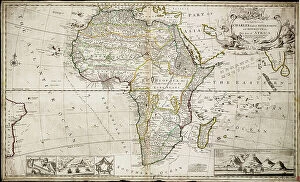
Background imageMaps Collection: Map of Africa, c.1715 (coloured engraving)

Map of Africa, c.1715 (coloured engraving)
7339356 Map of Africa, c.1715 (coloured engraving) by Moll, Hermann (fl.1678-1732); 60x99 cm; National Maritime Museum, London, UK; (add.info.: Creator: Herman Moll Single sheet. Hand col. engr)

Background imageMaps Collection: The course of Delaware River from Philadelphia to Chester, North America, 1778 (coloured engraving)

The course of Delaware River from Philadelphia to Chester, North America, 1778 (coloured engraving)
7339440 The course of Delaware River from Philadelphia to Chester, North America, 1778 (coloured engraving) by Faden, William (1750-1836); 45x68 cm; National Maritime Museum, London

Background imageMaps Collection: Louisburg fortress and harbour, Cape Breton, c.1745 (manuscript)

Louisburg fortress and harbour, Cape Breton, c.1745 (manuscript)
7339438 Louisburg fortress and harbour, Cape Breton, c.1745 (manuscript) by Unknown artist, (18th century); 53x77 cm; National Maritime Museum, London

Background imageMaps Collection: This geographical plan of the Island of Saint Helena is dedicated by permission to Field Marshal

This geographical plan of the Island of Saint Helena is dedicated by permission to Field Marshal His Royal Highness
7339435 This geographical plan of the Island of Saint Helena is dedicated by permission to Field Marshal His Royal Highness the Duke of Kent and Strathearn

Background imageMaps Collection: Index chart to the following survey of the coast of Karamania, 1819 (engraving)

Index chart to the following survey of the coast of Karamania, 1819 (engraving)
7339425 Index chart to the following survey of the coast of Karamania, 1819 (engraving) by Beaufort, Francis (fl.1819); 60x75 cm; National Maritime Museum, London

Background imageMaps Collection: St. George's Bay surveyed by Edward Bransfield, Master of HMS 'Andromache', 1821 (print)

St. George's Bay surveyed by Edward Bransfield, Master of HMS 'Andromache', 1821 (print)
7339419 St. George's Bay surveyed by Edward Bransfield, Master of HMS 'Andromache', 1821 (print) by Bransfield, Edward (19th century); 41x85.5 cm; National Maritime Museum, London

Background imageMaps Collection: Chart of South Shetland including Coronation Island, from the exploration of the sloop Dove in

Chart of South Shetland including Coronation Island, from the exploration of the sloop Dove in the years 1821
7339411 Chart of South Shetland including Coronation Island, from the exploration of the sloop Dove in the years 1821 and 1822 by George Powell Commander of the same, 1822 (engraving) by Powell

Background imageMaps Collection: Jaygad (Jyghur) and entrance to Shatri River..., 1880 (coloured photozincograph)

Jaygad (Jyghur) and entrance to Shatri River..., 1880 (coloured photozincograph)
7339408 Jaygad (Jyghur) and entrance to Shatri River..., 1880 (coloured photozincograph) by Jarrad, Frederick W. (19th century); 68x100 cm; National Maritime Museum, London

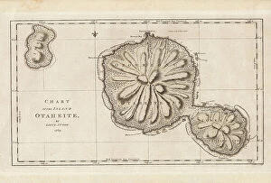
Background imageMaps Collection: Chart of the Island Otaheite (Tahiti) by James Cook, 1769, 1773 (engraving)

Chart of the Island Otaheite (Tahiti) by James Cook, 1769, 1773 (engraving)
7339404 Chart of the Island Otaheite (Tahiti) by James Cook, 1769, 1773 (engraving) by Cook, James (1728-79); 24x41 cm; National Maritime Museum, London

Background imageMaps Collection: Chart of Gulf of Guinea, Africa, early 18th century (engraving)

Chart of Gulf of Guinea, Africa, early 18th century (engraving)
7339402 Chart of Gulf of Guinea, Africa, early 18th century (engraving) by Keulen, Gerard van (1678-1726); 55x63 cm; National Maritime Museum, London

Background imageMaps Collection: South China Sea, 1757 (engraving)

South China Sea, 1757 (engraving)
7339394 South China Sea, 1757 (engraving) by Spanish School, (18th century); 31.5x42 cm; National Maritime Museum, London, UK; (add.info.: Creator: Pedro Manuel de Arandia; Laur)

Background imageMaps Collection: Sketch of Dusky Bay, New Zealand, 1773, 1777 (engraving)

Sketch of Dusky Bay, New Zealand, 1773, 1777 (engraving)
7339391 Sketch of Dusky Bay, New Zealand, 1773, 1777 (engraving) by Cook, James (1728-79); 21x38 cm; National Maritime Museum, London, UK; (add.info.: Creator: James Cook In Cook's second voyage)

Background imageMaps Collection: Map of Indochina, 1863 (print)

Map of Indochina, 1863 (print)
7339388 Map of Indochina, 1863 (print) by Walker, J. & C. (19th century); 69.5x69 cm; National Maritime Museum, London, UK; (add.info.: Creator: Great Britain. Admiralty)

Background imageMaps Collection: Carte d'une partie de la Mer de Chine dressee au Depot des Cartes et Plans de la Marine

Carte d'une partie de la Mer de Chine dressee au Depot des Cartes et Plans de la Marine
7339386 Carte d'une partie de la Mer de Chine dressee au Depot des Cartes et Plans de la Marine, sur les observations du Vice-Amiral Rosili, et publiee par ordre du Ministre

Background imageMaps Collection: Chart of the Galapagos, surveyed in the merchant ship 'Rattler', and drawn by Captain James Colnett

Chart of the Galapagos, surveyed in the merchant ship 'Rattler', and drawn by Captain James Colnett
7339384 Chart of the Galapagos, surveyed in the merchant ship 'Rattler', and drawn by Captain James Colnett, of the Royal Navy

Background imageMaps Collection: The Money brothers: William (1769-1834), James (1772-1833) and Robert Taylor (1775-1803)

The Money brothers: William (1769-1834), James (1772-1833) and Robert Taylor (1775-1803), 1788-92 (oil on canvas)
7337973 The Money brothers: William (1769-1834), James (1772-1833) and Robert Taylor (1775-1803), 1788-92 (oil on canvas) by Rigaud, John Francis (1742-1810); 101.6x127 cm; National Maritime Museum

Background imageMaps Collection: Part of North America, showing Sebastian Cabot's voyage to Newfoundland

Part of North America, showing Sebastian Cabot's voyage to Newfoundland
1578467 Part of North America, showing Sebastian Cabot's voyage to Newfoundland; (add.info.: Part of North America, showing Sebastian Cabot's voyage to Newfoundland)

Background imageMaps Collection: The Malabar Coast

The Malabar Coast
1578454 The Malabar Coast; (add.info.: The Malabar Coast. From Fra Mauro's map.); Universal History Archive/UIG.

Background imageMaps Collection: The voyage to Cape Blanco from Cape Bojador

The voyage to Cape Blanco from Cape Bojador
1578438 The voyage to Cape Blanco from Cape Bojador; (add.info.: The voyage to Cape Blanco from Cape Bojador. From Fra Mauro's map, 1457.); Universal History Archive/UIG.

Background imageMaps Collection: Africa - from Ceuta to Madeira, the canaries and Cape Bojador

Africa - from Ceuta to Madeira, the canaries and Cape Bojador
1578437 Africa - from Ceuta to Madeira, the canaries and Cape Bojador; (add.info.: Africa - from Ceuta to Madeira, the canaries and Cape Bojador)

Background imageMaps Collection: The unrolling of the Clouds:The world as known at the end of the 13th century , 1754 (illustration)

The unrolling of the Clouds:The world as known at the end of the 13th century , 1754 (illustration)
1578424 The unrolling of the Clouds:The world as known at the end of the 13th century , 1754 (illustration); (add.info.: The unrolling of the Clouds)

Background imageMaps Collection: The world map of Cosmas

The world map of Cosmas
1578415 The world map of Cosmas; (add.info.: The world map of Cosmas, 6th century.); Universal History Archive/UIG.

Background imageMaps Collection: An early map of 'Terra Australis', called 'Java La Grande' in its supposed eastern part

An early map of "Terra Australis", called "Java La Grande" in its supposed eastern part
1578489 An early map of "Terra Australis", called "Java La Grande" in its supposed eastern part; (add.info.: An early map of "Terra Australis")

Background imageMaps Collection: Map of the British Empire, the areas controlled by Britain are shaded in pink. 19th century (map)

Map of the British Empire, the areas controlled by Britain are shaded in pink. 19th century (map)
529503 Map of the British Empire, the areas controlled by Britain are shaded in pink. 19th century (map); Universal History Archive/UIG.

Background imageMaps Collection: The Bridge of a Merchant Ship at Sea, illustration from 'The Western Front', pub

The Bridge of a Merchant Ship at Sea, illustration from 'The Western Front', pub
STC403999 The Bridge of a Merchant Ship at Sea, illustration from 'The Western Front', pub. by Country Life Ltd, 1917 (litho) by Bone

Background imageMaps Collection: L'Atlas des Vins de France: Carte Generale (b/w photo)

L'Atlas des Vins de France: Carte Generale (b/w photo)
8675210 L'Atlas des Vins de France: Carte Generale (b/w photo) by French Photographer, (20th century); Private Collection; (add.info.: Carte Generale)

Background imageMaps Collection: Portrait of James Cook, 1728-1779 (litho)

Portrait of James Cook, 1728-1779 (litho)
8634698 Portrait of James Cook, 1728-1779 (litho) by English School, (20th century); Private Collection; (add.info.: James Cook, 1728-1779. Illustration for Armchair Science, 1931)

Background imageMaps Collection: Caesar, Gallic War: Helvetiorum Clades (litho)

Caesar, Gallic War: Helvetiorum Clades (litho)
8636509 Caesar, Gallic War: Helvetiorum Clades (litho) by English School, (20th century); Private Collection; (add.info.: Helvetiorum Clades)

Background imageMaps Collection: Zoogeography: Reptilia, Lacertilia, Crocodilia, Chelonia, Prosauria (colour litho)

Zoogeography: Reptilia, Lacertilia, Crocodilia, Chelonia, Prosauria (colour litho)
8636456 Zoogeography: Reptilia, Lacertilia, Crocodilia, Chelonia, Prosauria (colour litho) by English School, (20th century); Private Collection; (add.info.: Reptilia, Lacertilia, Crocodilia)

Background imageMaps Collection: Zoogeography: Mammalia, Edentata, Marsupialia, Monotremata (colour litho)

Zoogeography: Mammalia, Edentata, Marsupialia, Monotremata (colour litho)
8636450 Zoogeography: Mammalia, Edentata, Marsupialia, Monotremata (colour litho) by English School, (20th century); Private Collection; (add.info.: Mammalia, Edentata, Marsupialia, Monotremata)

Background imageMaps Collection: Sea of Galilee; Environs of Jerusalem (colour litho)

Sea of Galilee; Environs of Jerusalem (colour litho)
8630318 Sea of Galilee; Environs of Jerusalem (colour litho) by English School, (19th century); Private Collection; (add.info.: Sea of Galilee; Environs of Jerusalem)

Background imageMaps Collection: The Gentile Countries and Nations of the Old Testament, Countries etc of the New Testament

The Gentile Countries and Nations of the Old Testament, Countries etc of the New Testament (colour litho)
8630302 The Gentile Countries and Nations of the Old Testament, Countries etc of the New Testament (colour litho) by English School

Background imageMaps Collection: Pelerinages De L'Ile De France; Pelerinages Du Diocese De Paris (colour litho)

Pelerinages De L'Ile De France; Pelerinages Du Diocese De Paris (colour litho)
8643157 Pelerinages De L'Ile De France; Pelerinages Du Diocese De Paris (colour litho) by Clerget, Hubert (1818-1899); Private Collection; (add.info)

Background imageMaps Collection: Map of London Docks, showing extensions and improvements, 1909-37 (b/w photo)

Map of London Docks, showing extensions and improvements, 1909-37 (b/w photo)
8641412 Map of London Docks, showing extensions and improvements, 1909-37 (b/w photo) by English Photographer, (20th century); Private Collection; (add.info.: Map of London Docks)

Background imageMaps Collection: Panama Canal and Canal Zone (colour litho)

Panama Canal and Canal Zone (colour litho)
8642790 Panama Canal and Canal Zone (colour litho) by American School, (20th century); Private Collection; (add.info.: Panama Canal and Canal Zone)

Background imageMaps Collection: Pelerinages De La Provence De La Corse De L'Algerie Et De La Martinique (colour litho)

Pelerinages De La Provence De La Corse De L'Algerie Et De La Martinique (colour litho)
8642059 Pelerinages De La Provence De La Corse De L'Algerie Et De La Martinique (colour litho) by Clerget, Hubert (1818-1899); Private Collection; (add.info)

Background imageMaps Collection: Pelerinages Du Languedoc (colour litho)

Pelerinages Du Languedoc (colour litho)
8642056 Pelerinages Du Languedoc (colour litho) by Clerget, Hubert (1818-1899); Private Collection; (add.info.: Pelerinages Du Languedoc)

Background imageMaps Collection: Plan of Winchester (b/w photo)

Plan of Winchester (b/w photo)
8648814 Plan of Winchester (b/w photo) by English Photographer, (20th century); Private Collection; (add.info.: Plan of Winchester)

Background imageMaps Collection: Map of the Kerry and Cork Highlands (b/w photo)

Map of the Kerry and Cork Highlands (b/w photo)
8648806 Map of the Kerry and Cork Highlands (b/w photo) by English Photographer, (20th century); Private Collection; (add.info.: Map of the Kerry and Cork Highlands)

Background imageMaps Collection: Map of Wessex (b/w photo)

Map of Wessex (b/w photo)
8648791 Map of Wessex (b/w photo) by English Photographer, (20th century); Private Collection; (add.info.: Map of Wessex. Illustration for The British Isles Depicted by Pen and Camera (Cassell)

Background imageMaps Collection: Plan of Leeds (b/w photo)

Plan of Leeds (b/w photo)
8648788 Plan of Leeds (b/w photo) by English Photographer, (20th century); Private Collection; (add.info.: Plan of Leeds. Illustration for The British Isles Depicted by Pen and Camera (Cassell)


All Professionally Made to Order for Quick Shipping

Maps have always been a fascinating window into the past, allowing us to explore and understand the world as it once was. From the intricate details of an ancient Greek map to the vibrant landscapes of Jamaica, each map tells its own unique story. Take a journey back in time with a Map of Ancient Greece, where you can trace the footsteps of philosophers and warriors alike. Discover the birthplace of democracy and marvel at the city-states that shaped Western civilization. Venture further across continents with Maps showcasing the vastness of empires like Britain's. Explore territories under British rule through a Map of the British Empire or delve into Asia's history with a Map highlighting the mighty Mongol Empire. Uncover remnants of one of history's greatest civilizations with a Map depicting the grandeur and reach of Rome. Witness how this powerful empire spanned across Europe, Africa, and Asia, leaving behind an indelible mark on human history. During times filled with turmoil and conflict, maps served as crucial tools for understanding war efforts. The Daily Mail War Map from World War I provides insights into battlefronts while WW2 posters display strategic plans like never before - including those detailing activities specific to divisions such as 52 (Lowland) Division or mapping out positions held by troops in The British Army. Closer to home lies Isle Of Wight - its beauty captured perfectly on a detailed map inviting exploration along its stunning coastline. Meanwhile, travel even further east to discover ancient Persian splendor through an intricately designed Persian Empire map. For those seeking nostalgia or tracing ancestral roots, immerse yourself in Cornwall C1857's historical charm via an antique map capturing its essence during that era. From ancient civilizations to modern-day conflicts and everything in between – they can not just pieces of paper but gateways into our collective pasts. They hold stories waiting to be unraveled by curious minds eager for knowledge about our ever-changing world throughout time.