
Land Map Section Collection
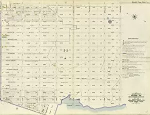
The Land Map Section is a crucial aspect of urban planning and development in Brooklyn Borough, New York City


All Professionally Made to Order for Quick Shipping
The Land Map Section is a crucial aspect of urban planning and development in Brooklyn Borough, New York City. It encompasses various wards and volumes, each with its unique characteristics and features. In Wards 22 & 29, the Land Map Section plays a significant role in delineating boundaries and providing essential information for land use planning. Similarly, Ward 29 alone has its own designated section labeled as No. 16 in Volume This particular area holds vital data that aids in understanding the layout and potential developments within this ward. Expanding further, the Land Map Section extends to Wards 30, 31 & 32 as well. These sections are also identified by No. 16 in Volume 2 of Brooklyn Borough's records. The inclusion of multiple wards highlights the interconnectedness of these areas when it comes to land management and future growth prospects. Moving on to Wards 27 &28, another distinct Land Map Section exists without specific numbering mentioned here. However, it remains an integral part of urban planning efforts within these wards. Ward combinations continue to shape the Land Map Sections' scope as seen in Wards 29 &32 where they share a common designation but lack specific numbering details. Within Ward 8 lies yet another noteworthy section known as No. 3 found in Volume1 of Brooklyn Borough's records. This particular area carries valuable information regarding land usage patterns and potential development opportunities for this ward specifically. Moreover, Ward12 also possesses its own dedicated section labeled as No. 2 within Volume1 of Brooklyn Borough's records - offering insights into land utilization strategies tailored for this ward's unique requirements. Lastly, Ward26 boasts its distinctive Land Map Section marked as No. 13 within Volume1 of Brooklyn Borough's records – serving as a comprehensive guide for planners seeking to enhance this ward's infrastructure while preserving its natural beauty.