
Grand Street Collection
"Grand Street: A Historic Journey Through Manhattan's Heart" Step back in time as we explore the captivating allure of Grand Street


All Professionally Made to Order for Quick Shipping
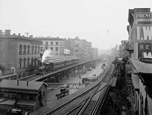
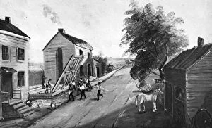
"Grand Street: A Historic Journey Through Manhattan's Heart" Step back in time as we explore the captivating allure of Grand Street, a bustling thoroughfare that has witnessed the evolution of New York City. From its humble beginnings to becoming an integral part of the city's fabric, Grand Street holds countless stories within its vibrant tapestry. Gazing at "The Bowery from Grand Street, " a mesmerizing black and white photograph, one can almost hear the echoes of horse-drawn carriages and feel the energy pulsating through this iconic intersection. The night view at Orchard Street in 1917 transports us to an era where gas lamps illuminated cobblestone streets, casting enchanting shadows on passersby. As we delve deeper into history, Borough of Manhattan reveals itself through another monochromatic lens. This snapshot captures not just buildings but also dreams taking shape amidst towering structures. Plate 26 unfolds before our eyes with a meticulously detailed map bounded by Ludlow Street, Rivington Street, Ridge Street, and Division – each street name whispering tales untold. Continuing our journey along Plate 25's boundaries – Bowery, Rivington Street, Ludlow Street, Canal Street – we uncover hidden gems nestled within this urban maze, and is here that cultures collide and communities thrive; a microcosm reflecting New York City's diversity. Plate 23 beckons us further westward with its map bounded by Canal Street, Broadway Broome Streets - revealing secrets waiting to be discovered around every corner. Meanwhile Plate 22 invites exploration between Thompson and Spring Streets - where artistry meets commerce in a delicate dance. Venturing southwards towards Sullivan and Varick Streets via Plate 18 & 20 respectively unveils neighborhoods teeming with life; their essence captured forever in these maps' intricate details. These snapshots offer glimpses into lives lived against backdrops shaped by progress and change.