Fraud Blocker Skip to main content

Geographic Illustration Collection

"Exploring the World from Above

Background imageGeographic Illustration Collection: Globe North Pole, True Colour Satellite Image. Cloudless true colour satellite image of the Earth, c

Globe North Pole, True Colour Satellite Image. Cloudless true colour satellite image of the Earth, centred on the Arctic or north polar region

Background imageGeographic Illustration Collection: Asia At Night With Country Borders, True Colour Satellite Image

Asia At Night With Country Borders, True Colour Satellite Image. True colour satellite image of Asia at night with country borders

Background imageGeographic Illustration Collection: Globe Centred On Asia And Oceania, True Colour Satellite Image Of The Earth

Globe Centred On Asia And Oceania, True Colour Satellite Image Of The Earth
Globe Centred On Asia And Oceania, True Colour Satellite Image. True colour satellite image of the Earth centred on Asia and Oceania with cloud coverage, during summer solstice at 6 a.m GMT

Background imageGeographic Illustration Collection: Globe Showing Europe, True Colour Satellite Image Of The Earth Showing Greenland, North Pole, Europe

Globe Showing Europe, True Colour Satellite Image Of The Earth Showing Greenland, North Pole, Europe
Globe Showing Europe, True Colour Satellite Image. True colour satellite image of the Earth showing Greenland, the North Pole and Europe, with cloud coverage

Background imageGeographic Illustration Collection: Satellite view of Adams Bridge. This chain of limestone shoals connects Sri Lanka to India

Satellite view of Adams Bridge. This chain of limestone shoals connects Sri Lanka to India. This image was taken in 2014 by Landsat 8 satellite

Background imageGeographic Illustration Collection: Whole Earth At Night Centred On Pacific Ocean, True Colour Satellite Image Of The Earth

Whole Earth At Night Centred On Pacific Ocean, True Colour Satellite Image Of The Earth
Whole Earth At Night Centred On Pacific Ocean, True Colour Satellite Image. True colour satellite image of the whole Earth at night, centred on the Pacific Ocean, with country borders

Background imageGeographic Illustration Collection: Whole Earth Centred On Pacific Ocean, True Colour Satellite Image Of The Earth

Whole Earth Centred On Pacific Ocean, True Colour Satellite Image Of The Earth
Whole Earth Centred On Pacific Ocean, True Colour Satellite Image. True colour satellite image of the whole Earth centred on the Pacific Ocean, with bump effect

Background imageGeographic Illustration Collection: Globe Showing Europe And Africa, True Colour Satellite Image Of The Earth

Globe Showing Europe And Africa, True Colour Satellite Image Of The Earth
Globe Showing Europe And Africa, True Colour Satellite Image. True colour satellite image of the Earth showing Europe and Africa, half in shadow, and the sun

Background imageGeographic Illustration Collection: Globe Asia, True Colour Satellite Image. Earth. True colour satellite image of the Earth, centred

Globe Asia, True Colour Satellite Image. Earth. True colour satellite image of the Earth, centred on Asia. The North Pole is at upper centre

Background imageGeographic Illustration Collection: Africa At Night With Country Borders, True Colour Satellite Image

Africa At Night With Country Borders, True Colour Satellite Image. True colour satellite image of Africa at night with country borders

Background imageGeographic Illustration Collection: Globe Europe, True Colour Satellite Image. True colour satellite image of the whole earth, showing E

Globe Europe, True Colour Satellite Image. True colour satellite image of the whole earth, showing Europe at centre. The picture is a composite created from thousands of separate images recorded by

Background imageGeographic Illustration Collection: Globe Centred On Europe And Africa, True Colour Satellite Image Of The Earth

Globe Centred On Europe And Africa, True Colour Satellite Image Of The Earth
Globe Centred On Europe And Africa, True Colour Satellite Image. True colour satellite image of the Earth centred on Europe and Africa with cloud coverage, during summer solstice at 12 a.m GMT

Background imageGeographic Illustration Collection: Europe At Night With Cloud Coverage, True Colour Satellite Image

Europe At Night With Cloud Coverage, True Colour Satellite Image. True colour satellite image of Europe at night with cloud coverage

Background imageGeographic Illustration Collection: Globe Oceania, True Colour Satellite Image. Earth. True colour satellite image of the Earth, centred

Globe Oceania, True Colour Satellite Image. Earth. True colour satellite image of the Earth, centred on the region of Oceania. North is at top

Background imageGeographic Illustration Collection: Europe At Night, True Colour Satellite Image. True colour satellite image of Europe at night

Europe At Night, True Colour Satellite Image. True colour satellite image of Europe at night. This image in Lambert Conformal Conic projection was compiled from data acquired by LANDSAT 5 & 7

Background imageGeographic Illustration Collection: Globe South America, True Colour Satellite Image. Earth. True colour satellite image of the Earth, c

Globe South America, True Colour Satellite Image. Earth. True colour satellite image of the Earth, centred on South America. North is at top

Background imageGeographic Illustration Collection: Western Europe At Night, Satellite Image. Lights of Western Europe at night from space. Coloured ima

Western Europe At Night, Satellite Image. Lights of Western Europe at night from space. Coloured image derived from satellite data showing Western Europe at night

Background imageGeographic Illustration Collection: Globe Centred On The Americas, True Colour Satellite Image. True colour satellite image of

Globe Centred On The Americas, True Colour Satellite Image. True colour satellite image of the Earth centred on the Americas with cloud coverage, during summer solstice at 6 a.m GMT

Background imageGeographic Illustration Collection: Globe Africa, True Colour Satellite Image. Earth. True colour satellite image of the Earth, centred

Globe Africa, True Colour Satellite Image. Earth. True colour satellite image of the Earth, centred on Africa. North is at top

Background imageGeographic Illustration Collection: Globe Showing Asia, True Colour Satellite Image Of The Earth Showing Asia, Oceania And The Sun

Globe Showing Asia, True Colour Satellite Image Of The Earth Showing Asia, Oceania And The Sun
Globe Showing Asia, True Colour Satellite Image. True colour satellite image of the Earth showing Asia and Oceania, half in shadow, and the sun

Background imageGeographic Illustration Collection: Globe Showing Northern America, True Colour Satellite Image Of The Earth

Globe Showing Northern America, True Colour Satellite Image Of The Earth
Globe Showing Northern America, True Colour Satellite Image. True colour satellite image of the Earth showing Greenland, the North Pole and Northern America

Background imageGeographic Illustration Collection: Globe Showing The Americas, True Colour Satellite Image Of The Earth, Half In Shadow And The Sun

Globe Showing The Americas, True Colour Satellite Image Of The Earth, Half In Shadow And The Sun
Globe Showing The Americas, True Colour Satellite Image. True colour satellite image of the Earth showing the Americas, half in shadow, and the sun

Background imageGeographic Illustration Collection: Globe Showing Europe And Northern Africa, True Colour Satellite Image Of The Earth

Globe Showing Europe And Northern Africa, True Colour Satellite Image Of The Earth
Globe Showing Europe And Northern Africa, True Colour Satellite Image. True colour satellite image of the Earth showing Europe and Northern Africa, with cloud coverage

Background imageGeographic Illustration Collection: Globe Centred On The South Pole, True Colour Satellite Image Of The Earth

Globe Centred On The South Pole, True Colour Satellite Image Of The Earth
Globe Centred On The South Pole, True Colour Satellite Image. True colour satellite image of the Earth centred on the South Pole with cloud coverage, during summer solstice at 12 a.m GMT

Background imageGeographic Illustration Collection: North America At Night, True Colour Satellite Image. True colour satellite image of North America

North America At Night, True Colour Satellite Image. True colour satellite image of North America at night. This image in Lambert Conformal Conic projection was compiled from data acquired by LANDSAT

Background imageGeographic Illustration Collection: Whole Earth At Night With Cloud Coverage, True Colour Satellite Image

Whole Earth At Night With Cloud Coverage, True Colour Satellite Image. True colour satellite image of the whole Earth at night with cloud coverage

Background imageGeographic Illustration Collection: Globe North America, True Colour Satellite Image. Earth. True colour satellite image of the Earth, c

Globe North America, True Colour Satellite Image. Earth. True colour satellite image of the Earth, centred on North America. The North Pole is at upper centre


All Professionally Made to Order for Quick Shipping

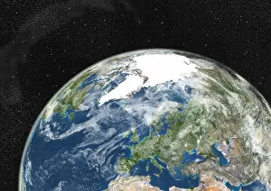
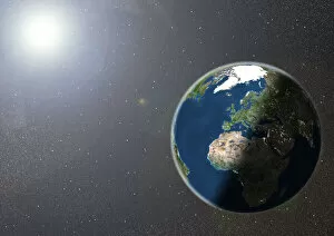
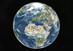
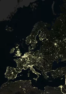
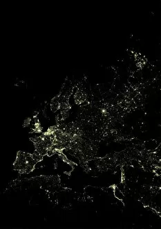
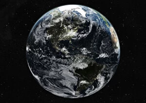
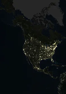
"Exploring the World from Above: A Collection of Geographic Illustrations" Immerse yourself in the breathtaking beauty of our planet with these stunning geographic illustrations. From Asia at night, adorned with country borders and captured by true color satellite imagery, to a captivating view of Europe under a blanket of clouds, these images offer a unique perspective on Earth's diverse landscapes. Witness the mesmerizing glow of Asia at night as its countries come alive in this Lambert Azimuthal Equal Area projection. Compiled from data acquired by LANDSAT 5 & 7 satellites, this true color satellite image showcases the vibrant tapestry that is Asia after sunset. Marvel at our globe showcasing Europe, where Greenland stands out against the backdrop of the North Pole. This true color satellite image provides an extraordinary glimpse into Europe's geographical wonders and its connection to neighboring regions. Delve into history as you explore Adams Bridge, a chain of limestone shoals that links Sri Lanka to India. This satellite view offers an intriguing perspective on this natural marvel and highlights how geography has shaped human connectivity over time. Embark on a journey through space as you gaze upon our whole Earth at night centered on the Pacific Ocean. Captured by true color satellite imagery, this awe-inspiring illustration reveals how cities illuminate our world even when darkness prevails. Indulge your curiosity further with another captivating image centered solely on the Pacific Ocean. Offering unparalleled detail and clarity through true color satellite imaging technology, this illustration allows us to appreciate Earth's vastness while highlighting key features across continents. Expand your horizons with a globe showcasing both Europe and Africa in all their glory. Through vivid colors captured by satellites orbiting above us, witness these two continents harmoniously coexisting amidst oceans teeming with life. Discover Asia anew through an exquisite true-color satellite image centred around its majestic lands. Let your imagination soar as you explore every corner of this vast continent filled with rich cultures and breathtaking landscapes.