
Delisle Collection
"Delisle's Map of Colonial America: Unveiling the Rich History and Vast Territories of a New World" Step back in time with Delisle's remarkable map of colonial America


All Professionally Made to Order for Quick Shipping
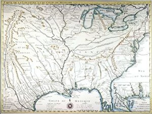
"Delisle's Map of Colonial America: Unveiling the Rich History and Vast Territories of a New World" Step back in time with Delisle's remarkable map of colonial America, crafted in 1718. This captivating cartographic masterpiece offers a glimpse into the unexplored lands that would shape the course of history. With its intricate details and meticulous craftsmanship, this map serves as a window to an era when discovery and conquest were at their peak. As you study Delisle's creation, your eyes will be drawn to the mighty Mississippi River, prominently showcased as it winds its way through the heartland. A lifeline for trade and exploration, this majestic waterway symbolizes both opportunity and challenge for early settlers venturing into unknown territories. The carefully plotted boundaries on Delisle's map reveal the vastness of colonial America during this transformative period. From French Louisiana to British colonies along the eastern seaboard, each region is meticulously labeled, offering insights into diverse cultures and influences that shaped these lands. Delving deeper into this historical gem reveals not only geographical features but also intriguing hints about life in colonial times. The presence of settlements marked by tiny dots signifies bustling towns where dreams were pursued amidst untamed wilderness. These dots represent stories waiting to be unraveled - tales of resilience, struggle, triumphs, and tragedies etched upon every inch of this parchment. Beyond its practical purpose as a navigational tool for explorers or traders seeking new routes or markets lies an artistic marvel that captures imaginations even today. Delisle's attention to detail transforms mere lines on paper into vivid landscapes teeming with possibilities – inviting us all to embark on our own journey through time. So take a moment to immerse yourself in Delisle's extraordinary creation – let your imagination soar across uncharted territories while tracing paths once treaded by pioneers who dared to dream big.