Fraud Blocker Skip to main content

Combined Data Collection

"Unlocking the Secrets of Our Planet

Background imageCombined Data Collection: Europe at night, satellite image

Europe at night, satellite image. City lights (yellow) show areas of dense population. There are few lights in North Africa (bottom) and the Arctic (top) since they are more sparsely populated

Background imageCombined Data Collection: Earth, topographic and bathymetric map

Earth, topographic and bathymetric map. This whole Earth map is centred on the Greenwich meridian, at zero degrees latitude

Background imageCombined Data Collection: Australia, topographic map

Australia, topographic map. Highlands and lowlands of the continents are shown as ridges and flat areas. Southeast Asia (top left), New Zealand (lower right) and Antarctica (bottom right)

Background imageCombined Data Collection: South America at night, satellite image

South America at night, satellite image. City lights (yellow) show areas of dense population, particularly in North America (top left) and South Americas coasts

Background imageCombined Data Collection: North America at night, satellite image

North America at night, satellite image. City lights (yellow) show areas of dense population, particularly in North America (upper centre)

Background imageCombined Data Collection: Earth, topographic and bathymetric map

Earth, topographic and bathymetric map. This map is centred on the Pacific Ocean, at longitude 140 degrees west. Highlands and lowlands of the continents are shown as ridges and flat areas

Background imageCombined Data Collection: Whole Earth, satellite image

Whole Earth, satellite image. This map is centred on the Greenwich meridian, at zero degrees latitude. Arctic and Antarctic ice is white, oceans are blue and land is green and brown

Background imageCombined Data Collection: Africa, satellite image

Africa, satellite image
Africa. Satellite image of the Earth centred on Africa. Clouds are white, oceans are blue and land is green and brown. Also seen are Europe (top) Asia (upper right), the Indian Ocean (right)

Background imageCombined Data Collection: Southeast Asia at night, satellite image

Southeast Asia at night, satellite image
Southeast Asia at night. Satellite image of the Earth seen at 18:00 (6pm) GMT (UCT), centred on China. City lights (yellow) show areas of dense population, particularly in India (left)

Background imageCombined Data Collection: Whole Earth at night, satellite image

Whole Earth at night, satellite image. This map is centred on the Greenwich meridian, at zero degrees latitude. City lights (yellow) show areas of dense population

Background imageCombined Data Collection: Africa, topographic map

Africa, topographic map. Highlands and lowlands of the continents are shown as ridges and flat areas. Southern Europe and the Middle East are also seen at top and upper right respectively

Background imageCombined Data Collection: Australia at night, satellite image

Australia at night, satellite image. City lights (yellow) show areas of more dense population, particularly in Southeast Asia (top left) and on Australias east coast

Background imageCombined Data Collection: North America, topographic map

North America, topographic map. Highlands and lowlands of the continents are also shown, as ridges and flat areas. South America (bottom right) and the Arctic (top) are also seen

Background imageCombined Data Collection: The Arctic, satellite image

The Arctic, satellite image
The Arctic. Satellite image of the Earth centred on the Arctic. The North Pole is at centre. Clouds and Arctic sea ice are white, oceans are blue and land is green and brown

Background imageCombined Data Collection: South America, topographic map

South America, topographic map. Highlands and lowlands of the continents are also shown, as ridges and flat areas. North America and the Caribbean (top left) and Antarctica (bottom right)

Background imageCombined Data Collection: Africa at night, satellite image

Africa at night, satellite image. City lights (yellow) show areas of dense population, particularly in Europe and the Middle East (top)

Background imageCombined Data Collection: Eurasia, topographic map

Eurasia, topographic map. This map is centred on Russia, with Europe at centre left and East Asia at right. The North Pole (upper left), with Greenland shown in white

Background imageCombined Data Collection: East Asia at night, satellite image

East Asia at night, satellite image
East Asia at night. Satellite image of the Earth at night, centred over China. City lights (yellow) show areas of dense population

Background imageCombined Data Collection: Europe at night, satellite image

Europe at night, satellite image
Europe at night. Satellite image of the Earth seen at 00:00 (midnight) GMT (UTC), centred on Europe. City lights (yellow) in dark areas show areas of dense population

Background imageCombined Data Collection: The Americas, satellite image

The Americas, satellite image. Oceans are blue and land is green and brown. City lights (yellow) in dark areas show areas of dense population

Background imageCombined Data Collection: Asia at night, satellite image

Asia at night, satellite image. City lights (yellow) show areas of dense population. Large, densely populated areas include India (lower centre), China (lower right) and Japan (right)

Background imageCombined Data Collection: Arabian Sea, satellite image

Arabian Sea, satellite image
Arabian Sea. Satellite image of the Earth centred on the Arabian Sea and western India. Clouds and Arctic ice (top) are white, oceans are blue and land is green and brown

Background imageCombined Data Collection: The Americas, satellite image

The Americas, satellite image
The Americas. Satellite image of the Earth centred on the Caribbean Islands, with North America at upper left and South America at bottom

Background imageCombined Data Collection: Northern Asia and the Arctic

Northern Asia and the Arctic. Satellite image of the Earth centred on Siberia, with the North Pole at upper centre. Clouds and Arctic sea ice are white, oceans are blue and land is green and brown


All Professionally Made to Order for Quick Shipping

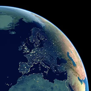
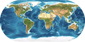
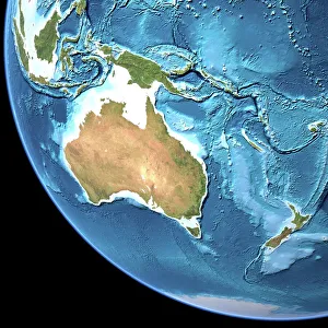
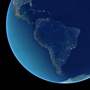
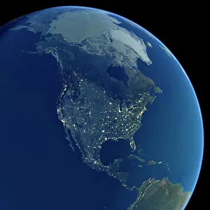
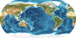
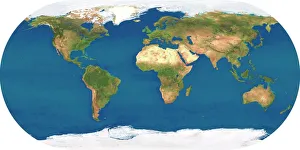
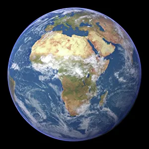
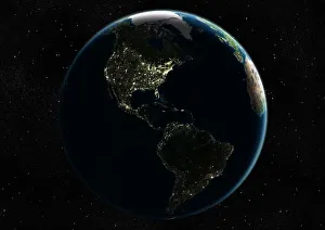
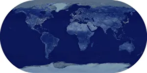
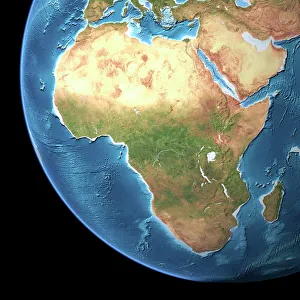
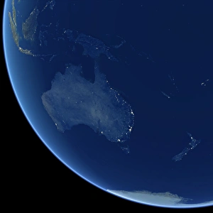
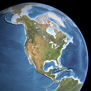
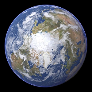
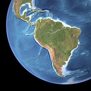
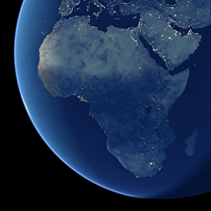
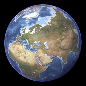
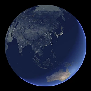
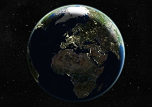
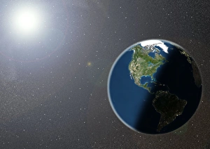
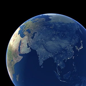
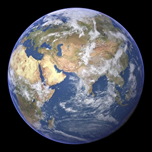
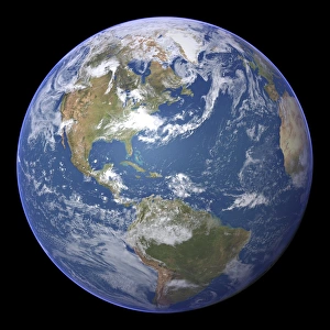
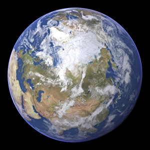
"Unlocking the Secrets of Our Planet: Exploring Combined Data from Earth's Diverse Landscapes and Nighttime Illuminations" Embark on a captivating journey as we delve into the fascinating realm of combined data, revealing hidden wonders across our magnificent planet. Starting with an intricate topographic and bathymetric map, witness Earth's diverse terrains unfold before your eyes. Marvel at Europe's shimmering cities under the cover of night, as captured by a satellite image. The twinkling lights paint a breathtaking tapestry that showcases human activity against nature's backdrop. Next, explore Australia through its detailed topographic map, unraveling its vast deserts, lush rainforests, and majestic coastlines. Then immerse yourself in South America's vibrant nightlife seen from space—a dazzling spectacle that highlights bustling metropolises amidst sprawling landscapes. Continuing our nocturnal odyssey over North America, behold the mesmerizing glow emanating from countless urban centers scattered across this vast continent. Witness how humans have transformed darkness into luminous artistry. Returning to an encompassing view of our entire planet at night—a satellite image capturing every corner illuminated—experience the interconnectedness of humanity amidst infinite darkness, and is here where borders blur and unity prevails. But let us not forget Africa—an awe-inspiring sight when observed from above—its unique contours brought to life by a striking satellite image. Discover its untamed beauty and rich cultural heritage etched upon this ancient land. Venturing further eastward to Southeast Asia at night reveals another symphony of light dancing beneath us—a testament to progress interwoven with centuries-old traditions thriving side by side. Finally, gaze upon Earth once more in all its glory—a stunning satellite image showcasing both day and nighttime splendor simultaneously. This visual masterpiece encapsulates our collective existence within this fragile blue dot suspended in space.