Fraud Blocker Skip to main content

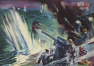
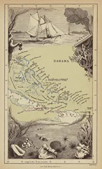
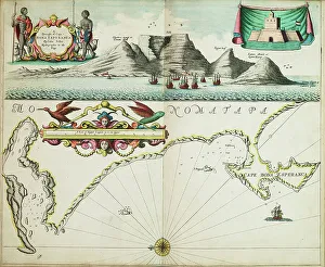
Atlantic Ocean Collection (page 15)

"Discover the vast beauty of the Atlantic Ocean, stretching from South Africa's Western Cape to the captivating cityscape of Cape Town

Background imageAtlantic Ocean Collection: View of the beach of Pornichet (View of the beach of Pornichet) Postcard ca. 1915

View of the beach of Pornichet (View of the beach of Pornichet) Postcard ca. 1915
ELD4953924 View of the beach of Pornichet (View of the beach of Pornichet) Postcard ca. 1915; Private Collection; (add.info)

Background imageAtlantic Ocean Collection: France, Pays de la Loire, Loire-Atlantique (44), La Baule Escoublac (Baule-Escoublac)

France, Pays de la Loire, Loire-Atlantique (44), La Baule Escoublac (Baule-Escoublac)
LUX4790076 France, Pays de la Loire, Loire-Atlantique (44), La Baule Escoublac (Baule-Escoublac): a group of children plays on the beach, 1900; (add.info.: France, Pays de la Loire)

Background imageAtlantic Ocean Collection: France, Aquitaine, Pyrenees-Atlantiques (64), Biarritz: The new casino, 1910

France, Aquitaine, Pyrenees-Atlantiques (64), Biarritz: The new casino, 1910
LUX4811575 France, Aquitaine, Pyrenees-Atlantiques (64), Biarritz: The new casino, 1910; (add.info.: France, Aquitaine, Pyrenees-Atlantiques (64), Biarritz: The new casino

Background imageAtlantic Ocean Collection: Lobster fishermen throwing their trap, Atlantic sea. Late 19th century (chromolithograph)

Lobster fishermen throwing their trap, Atlantic sea. Late 19th century (chromolithograph)
ELD4847598 Lobster fishermen throwing their trap, Atlantic sea. Late 19th century (chromolithograph); Private Collection; Photo © The Holbarn Archive.

Background imageAtlantic Ocean Collection: France, Aquitaine, Pyrenees-Atlantiques (64), Biarritz: Cote des Basques, a big wave, 1900

France, Aquitaine, Pyrenees-Atlantiques (64), Biarritz: Cote des Basques, a big wave, 1900
LUX4771763 France, Aquitaine, Pyrenees-Atlantiques (64), Biarritz: Cote des Basques, a big wave, 1900; (add.info.: France, Aquitaine, Pyrenees-Atlantiques (64), Biarritz: Cote des Basques

Background imageAtlantic Ocean Collection: The steamer The Great Britain, 1850

The steamer The Great Britain, 1850
3478576 The steamer 'The Great Britain', 1850; (add.info.: Illustration depicting the steamer 'The Great Britain', the first screw steamer to cross the Atlantic)

Background imageAtlantic Ocean Collection: Laying the Trans-Atlantic cable, 1857

Laying the Trans-Atlantic cable, 1857
3478754 Laying the Trans-Atlantic cable, 1857; (add.info.: Valentia 1857-1858, the first attempt to lay the Atlantic telegraph cable at Foilhommerum Bay, near Valentia)

Background imageAtlantic Ocean Collection: The Great eastern steamship used to lift the Atlantic telegraph cable, 1866

The Great eastern steamship used to lift the Atlantic telegraph cable, 1866
3478946 The 'Great eastern' steamship used to lift the Atlantic telegraph cable, 1866; (add.info.: The 'Great eastern' steamship used to lift the Atlantic telegraph cable)

Background imageAtlantic Ocean Collection: The laying of the Atlantic telegraph cable, 1858

The laying of the Atlantic telegraph cable, 1858
3478896 The laying of the Atlantic telegraph cable, 1858; (add.info.: Cartoon from Punch, 1858, at the time of the laying of the Atlantic telegraph cable)

Background imageAtlantic Ocean Collection: The steamer The Great Britain, 1850

The steamer The Great Britain, 1850
3478579 The steamer 'The Great Britain', 1850; (add.info.: Illustration depicting the steamer 'The Great Britain', the first screw steamer to cross the Atlantic)

Background imageAtlantic Ocean Collection: 600 lives rescued from the Connaught by the American ship Minnie Shiffe'r in the Atlantic

600 lives rescued from the Connaught by the American ship Minnie Shiffe'r in the Atlantic, 8 October 1860
7341905 600 lives rescued from the 'Connaught' by the American ship 'Minnie Shiffe'r in the Atlantic, 8 October 1860, 19th century (watercolour) by Brierly

Background imageAtlantic Ocean Collection: A chart of the harbour of Boston, 1775 (coloured engraving)

A chart of the harbour of Boston, 1775 (coloured engraving)
7340430 A chart of the harbour of Boston, 1775 (coloured engraving) by DesBarres, Joseph Frederick Wallet (1721-1824); 73x53 cm; National Maritime Museum, London, UK; (add.info.: Creator: J.F.W)

Background imageAtlantic Ocean Collection: Chart of the Atlantic Ocean, Mediterranean and Black Sea, c.1535 (vellum, paper)

Chart of the Atlantic Ocean, Mediterranean and Black Sea, c.1535 (vellum, paper)
7342734 Chart of the Atlantic Ocean, Mediterranean and Black Sea, c.1535 (vellum, paper) by Reinel, Pedro (fl.c.1519); 42.8x64.2 cm; National Maritime Museum, London

Background imageAtlantic Ocean Collection: The transportation of the cables used in the Atlantic Telegraph

The transportation of the cables used in the Atlantic Telegraph
5308161 The transportation of the cables used in the Atlantic Telegraph.; (add.info.: Print depicting the transportation of the cables used in the Atlantic Telegraph)

Background imageAtlantic Ocean Collection: Portulan chart of Mediterranean Sea and NE Atlantic, this is the oldest portulan in the National

Portulan chart of Mediterranean Sea and NE Atlantic, this is the oldest portulan in the National Maritime Museum's
7340476 Portulan chart of Mediterranean Sea and NE Atlantic, this is the oldest portulan in the National Maritime Museum's collections, 16th century (ink on vellum) by Spanish School

Background imageAtlantic Ocean Collection: Chart of Mediterranean and north east Atlantic, 1555 (vellum)

Chart of Mediterranean and north east Atlantic, 1555 (vellum)
7340472 Chart of Mediterranean and north east Atlantic, 1555 (vellum) by Lopes, Sebastião (16th century); 67x90 cm; National Maritime Museum, London

Background imageAtlantic Ocean Collection: Western Atlantic Ocean, 1660 (engraving)

Western Atlantic Ocean, 1660 (engraving)
7340467 Western Atlantic Ocean, 1660 (engraving) by Goos, Pieter (1616-1675); 81x64 cm; National Maritime Museum, London, UK; (add.info.: Creator: Pieter Goos Single sheet)

Background imageAtlantic Ocean Collection: Atlantic coasts of Europe, Norway to Finisterre, 1666 (vellum)

Atlantic coasts of Europe, Norway to Finisterre, 1666 (vellum)
7340461 Atlantic coasts of Europe, Norway to Finisterre, 1666 (vellum) by Comberford, Nicholas (d.1673); 79x27 cm; National Maritime Museum, London

Background imageAtlantic Ocean Collection: A general chart of the Atlantic Ocean north of the Equator, 1800 (engraving)

A general chart of the Atlantic Ocean north of the Equator, 1800 (engraving)
7340458 A general chart of the Atlantic Ocean north of the Equator, 1800 (engraving) by Unknown Artist, (19th century); 58.5x89.5 cm; National Maritime Museum, London

Background imageAtlantic Ocean Collection: A new hydrographical survey of the British Channel, with part of the Atlantic Ocean as far as Cape

A new hydrographical survey of the British Channel, with part of the Atlantic Ocean as far as Cape Clear
7340129 A new hydrographical survey of the British Channel, with part of the Atlantic Ocean as far as Cape Clear, improved from the large chart of the late Thomas Jeffery's Geographer to

Background imageAtlantic Ocean Collection: Chart of the north-east Atlantic, from Ireland to Cape Verde, c.1600 (manuscript)

Chart of the north-east Atlantic, from Ireland to Cape Verde, c.1600 (manuscript)
7339788 Chart of the north-east Atlantic, from Ireland to Cape Verde, c.1600 (manuscript) by Unknown Artist, (17th century); 47x35 cm; National Maritime Museum, London

Background imageAtlantic Ocean Collection: Map of the central Atlantic, 1592 (vellum)

Map of the central Atlantic, 1592 (vellum)
7339593 Map of the central Atlantic, 1592 (vellum) by Oliva, Joan (fl.16th-17th century); 1.9x25 cm; National Maritime Museum, London

Background imageAtlantic Ocean Collection: North Atlantic Ocean Chart showing deep sea soundings and tracks of telegraph cables

North Atlantic Ocean Chart showing deep sea soundings and tracks of telegraph cables, 1869 (lithograph)
7339548 North Atlantic Ocean Chart showing deep sea soundings and tracks of telegraph cables, 1869 (lithograph) by Malby (fl.1869); 66x93 cm; National Maritime Museum, London

Background imageAtlantic Ocean Collection: Chart showing the track of His Majesty's ship Centaur (1797) from England to Madeira and back

Chart showing the track of His Majesty's ship Centaur (1797) from England to Madeira and back, 1808 (ink, paper)
7339499 Chart showing the track of His Majesty's ship 'Centaur' (1797) from England to Madeira and back, 1808 (ink, paper, watercolour) by Unknown Artist

Background imageAtlantic Ocean Collection: Chart of the Galapagos, surveyed in the merchant ship Rattler, and drawn by Captain James Colnett

Chart of the Galapagos, surveyed in the merchant ship Rattler, and drawn by Captain James Colnett, of the Royal Navy
7339384 Chart of the Galapagos, surveyed in the merchant ship 'Rattler', and drawn by Captain James Colnett, of the Royal Navy

Background imageAtlantic Ocean Collection: Map of Iceland, c.1900 (engraving)

Map of Iceland, c.1900 (engraving)
533307 Map of Iceland, c.1900 (engraving); (add.info.: Map of Iceland showing glaciers (Jokull), fjords and other geographical features, circa 1902

Background imageAtlantic Ocean Collection: Map of South America, c.1900 (engraving)

Map of South America, c.1900 (engraving)
533256 Map of South America, c.1900 (engraving); (add.info.: Map of South America with inset maps of Isthmus of Panama, Galapagos Islands and Trinidad, circa 1902)

Background imageAtlantic Ocean Collection: Map of North Carolina, c.1900 (engraving)

Map of North Carolina, c.1900 (engraving)
533130 Map of North Carolina, c.1900 (engraving); (add.info.: Map of North Carolina, United States, circa 1902, from the 10th edition of Encyclopaedia Britannica.); Encyclopaedia Britannica/UIG.

Background imageAtlantic Ocean Collection: Sinking of HMS Rawalpindi, 1939 (colour litho)

Sinking of HMS Rawalpindi, 1939 (colour litho)
8675917 Sinking of HMS Rawalpindi, 1939 (colour litho) by English School, (20th century); Private Collection; (add.info.: Sinking of the British armed merchant cruiser HMS Rawalpindi by the German)

Background imageAtlantic Ocean Collection: Gibraltar (engraving)

Gibraltar (engraving)
8676824 Gibraltar (engraving) by English School, (19th century); Private Collection; (add.info.: Gibraltar. Illustration from The Illustrated News of the World, 2 July 1859.); © Look and Learn.

Background imageAtlantic Ocean Collection: HMS Agamemnon and USS Niagara laying the first transatlantic telegraph cable (engraving)

HMS Agamemnon and USS Niagara laying the first transatlantic telegraph cable (engraving)
8676433 HMS Agamemnon and USS Niagara laying the first transatlantic telegraph cable (engraving) by English School, (19th century); Private Collection; (add.info)

Background imageAtlantic Ocean Collection: Bahamas (engraving)

Bahamas (engraving)
8676275 Bahamas (engraving) by Pritchett, Robert (1828-1907); Private Collection; (add.info.: Bahamas. Illustration from In the Trades, the Tropics & the Roaring Forties)

Background imageAtlantic Ocean Collection: Modern Wonders, 1938: The Short-Mayo Composite Aircraft (colour photo)

Modern Wonders, 1938: The Short-Mayo Composite Aircraft (colour photo)
8659888 Modern Wonders, 1938: The Short-Mayo Composite Aircraft (colour photo) by English Photographer, (20th century); Private Collection; (add.info.: The Short-Mayo Composite Aircraft)

Background imageAtlantic Ocean Collection: Martha's Vineyard: The Gay Head Bluffs (b/w photo)

Martha's Vineyard: The Gay Head Bluffs (b/w photo)
8640644 Martha's Vineyard: The Gay Head Bluffs (b/w photo) by American Photographer, (19th century); Private Collection; (add.info.: The Gay Head Bluffs)

Background imageAtlantic Ocean Collection: Martha's Vineyard: The Monohansett, The Martha's Vineyard, The Nantucket, The Island Home

Martha's Vineyard: The Monohansett, The Martha's Vineyard, The Nantucket, The Island Home
8640633 Martha's Vineyard: The Monohansett, The Martha's Vineyard, The Nantucket, The Island Home, The River Queen (b/w photo) by American Photographer

Background imageAtlantic Ocean Collection: Martha's Vineyard: View Northwest from the Observatory, Samoset Avenue (b/w photo)

Martha's Vineyard: View Northwest from the Observatory, Samoset Avenue (b/w photo)
8640629 Martha's Vineyard: View Northwest from the Observatory, Samoset Avenue (b/w photo) by American Photographer, (19th century); Private Collection; (add.info)

Background imageAtlantic Ocean Collection: Martha's Vineyard: Circuit Avenue and Soldiers Fountain, Island House (b/w photo)

Martha's Vineyard: Circuit Avenue and Soldiers Fountain, Island House (b/w photo)
8640625 Martha's Vineyard: Circuit Avenue and Soldiers' Fountain, Island House (b/w photo) by American Photographer

Background imageAtlantic Ocean Collection: Martha's Vineyard: Sea View Avenue and View South, from the Observatory (b/w photo)

Martha's Vineyard: Sea View Avenue and View South, from the Observatory (b/w photo)
8640621 Martha's Vineyard: Sea View Avenue and View South, from the Observatory (b/w photo) by American Photographer, (19th century); Private Collection; (add.info)

Background imageAtlantic Ocean Collection: Martha's Vineyard: Cottage City, Ocean Park and the Highlands, from the Observatory (b/w photo)

Martha's Vineyard: Cottage City, Ocean Park and the Highlands, from the Observatory (b/w photo)
8640617 Martha's Vineyard: Cottage City, Ocean Park and the Highlands, from the Observatory (b/w photo) by American Photographer, (19th century); Private Collection; (add.info.: Cottage City)

Background imageAtlantic Ocean Collection: 8625967

8625967

Background imageAtlantic Ocean Collection: 8625964

8625964

Background imageAtlantic Ocean Collection: European river trade routes in early antiquity (litho)

European river trade routes in early antiquity (litho)
8663874 European river trade routes in early antiquity (litho) by German School, (20th century); Private Collection; (add.info.: Probable European river trade routes in early antiquity)

Background imageAtlantic Ocean Collection: Atlantic Ocean, Communications (colour litho)

Atlantic Ocean, Communications (colour litho)
8650828 Atlantic Ocean, Communications (colour litho) by English School, (20th century); Private Collection; (add.info.: Atlantic Ocean, Communications)

Background imageAtlantic Ocean Collection: Coastwise: Newquay from the Harbour (b/w photo)

Coastwise: Newquay from the Harbour (b/w photo)
8671413 Coastwise: Newquay from the Harbour (b/w photo) by English Photographer, (20th century); Private Collection; (add.info.: Newquay from the Harbour)

Background imageAtlantic Ocean Collection: Atlantic 5 degrees South to 56 degrees North, 1674 (vellum)

Atlantic 5 degrees South to 56 degrees North, 1674 (vellum)
7340460 Atlantic 5 degrees South to 56 degrees North, 1674 (vellum) by Welch, Andrew (fl.1674); 71x99 cm; National Maritime Museum, London

Background imageAtlantic Ocean Collection: A new map of Ireland civil and ecclesiastical, 1797 (manuscript)

A new map of Ireland civil and ecclesiastical, 1797 (manuscript)
7340441 A new map of Ireland civil and ecclesiastical, 1797 (manuscript) by Beaufort, Daniel Augustus (1739-1821); 53x88 cm; National Maritime Museum, London, UK; (add.info.: Creator: Daniel A)

Background imageAtlantic Ocean Collection: The British Channel with a part of the Atlantic Ocean and of the Coast of Ireland, 1788 (print)

The British Channel with a part of the Atlantic Ocean and of the Coast of Ireland, 1788 (print)
7340084 The British Channel with a part of the Atlantic Ocean and of the Coast of Ireland, 1788 (print) by Sayer, Robert (1724/5-94); 44.2x92.9 cm; National Maritime Museum, London

Background imageAtlantic Ocean Collection: A chart of Guinea describing the sea coast from Cape de Verde to Cape Bona Esperanca

A chart of Guinea describing the sea coast from Cape de Verde to Cape Bona Esperanca, 1677 (coloured engraving)
7340049 A chart of Guinea describing the sea coast from Cape de Verde to Cape Bona Esperanca, 1677 (coloured engraving) by Seller, John (1632-97); 43x54 cm; National Maritime Museum, London


All Professionally Made to Order for Quick Shipping

"Discover the vast beauty of the Atlantic Ocean, stretching from South Africa's Western Cape to the captivating cityscape of Cape Town. Take in the breathtaking aerial view of Table Mountain as it majestically overlooks this coastal gem. Reflect on history as you imagine the Pilgrims aboard their ship Mayflower, setting sail across these very waters in 1620. Travel further north and explore Iceland through a vintage map from the 1800s, showcasing its connection to this mighty ocean. Experience the power of nature at Polzeath beach, where you can witness the mesmerizing Atlantic surf while gazing towards Pentire Headland. Venture to Scotland's Inner Hebrides and discover Dunvegan Castle on Isle of Skye, standing proudly amidst this maritime landscape. Immerse yourself in Portugal's rich culture with a glimpse into Funchal's cityscape viewed from sea, located on Madeira Island. Capture serenity at Portree Harbour on Isle of Skye in Scotland, where colorful boats dance upon gentle waves under an ever-changing sky. Witness a magical sunset over Bloubergstrand as Table Mountain paints a stunning backdrop for Cape Town once again. Embark on an Irish adventure along County Clare's Cliffs of Moher that dramatically meet with the Atlantic Ocean’s crashing waves. Marvel at Killer Whales or Orcas gracefully swimming through these deep blue waters—a testament to nature’s wonders. Finally, let your imagination sail back in time as Viking ships conquer these seas—unleashing tales of exploration and conquest that have shaped our world today. " Note.