Home > South America > Argentina > Maps
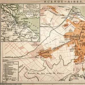
Antique Map of the East Coast of Patagonia

![]()
Wall Art and Photo Gifts from Fine Art Storehouse
Antique Map of the East Coast of Patagonia
Antique Map of the East Coast of Patagonia in the 16th Century
Unleash your creativity and transform your space into a visual masterpiece!
duncan1890
Media ID 24221395
© duncan1890
16th Century Style Argentina Coastal Feature Equipment Image Created 16th Century Land Land Feature Medieval Middle Ages Natural Phenomenon Navigational Equipment Past Patagonia South America Styles The Americas Obsolete
FEATURES IN THESE COLLECTIONS
> Fine Art Storehouse
> Map
> Historical Maps
> Fine Art Storehouse
> Travel Imagery
> Travel Destinations
> patagonia
> Maps and Charts
> Early Maps
> South America
> Argentina
> Maps
EDITORS COMMENTS
This print transports us back to the 16th century, offering a glimpse into the intricate cartography of Patagonia's East Coast. Created in the style of medieval woodcut illustrations, this antique map showcases the rich history and natural phenomenon that shaped this region of South America. Every detail is meticulously engraved, capturing both land and coastal features with remarkable precision. Navigational equipment from centuries past adorns the margins, reminding us of the challenges faced by explorers during this era. The obsolete yet fascinating depiction of old-fashioned equipment serves as a testament to human curiosity and determination. As we study this image created over four centuries ago, it becomes evident how much our understanding of geography has evolved. This print offers an invaluable window into a time when exploration was at its peak, shedding light on how early civilizations perceived their world. The allure lies not only in its historical significance but also in its artistic merit. The delicate lines and intricate patterns showcase the craftsmanship involved in creating such maps during the Middle Ages. It is through works like these that we can appreciate both artistry and scientific knowledge intertwined. Duncan1890's reproduction allows us to bring home a piece of history while adding an air of sophistication to any space it graces. Whether you are an avid collector or simply captivated by ancient cartography, this antique map print will undoubtedly spark conversations about exploration, culture, and our ever-evolving relationship with our planet's landscapes throughout time.
MADE IN THE USA
Safe Shipping with 30 Day Money Back Guarantee
FREE PERSONALISATION*
We are proud to offer a range of customisation features including Personalised Captions, Color Filters and Picture Zoom Tools
SECURE PAYMENTS
We happily accept a wide range of payment options so you can pay for the things you need in the way that is most convenient for you
* Options may vary by product and licensing agreement. Zoomed Pictures can be adjusted in the Cart.