Home > Arts > Landscape paintings > Waterfall and river artworks > River artworks
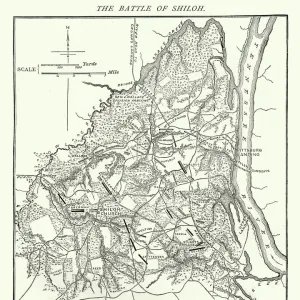
Battle of Port Royal

![]()
Wall Art and Photo Gifts from Fine Art Storehouse
Battle of Port Royal
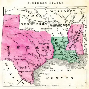
Vintage engraving from 1863 of a map of the Battle of Port Royal which was one of the earliest amphibious operations of the American Civil War, in which a United States Navy fleet and United States Army expeditionary force captured Port Royal Sound, South Carolina
Unleash your creativity and transform your space into a visual masterpiece!
duncan1890
Media ID 14757186
© duncan1890
Aggression American Civil War American Culture Amphibian Battle Battlefield Chart Civil War Coastal Feature Conflict Document Equipment Historical War Event Illustrations And Vector Art Image Created 1860 1869 Information Equipment Land Military Natural Phenomenon Navigational Equipment Navy North America North Carolina Objects Equipment Past Plan Printed Media South Carolina Southern Usa Styles The Americas Traditional Culture Travel Locations Us Military Us Navy Beaufort Image Created 19th Century Obsolete Port Royal
FEATURES IN THESE COLLECTIONS
> Arts
> Landscape paintings
> Waterfall and river artworks
> River artworks
> Fine Art Storehouse
> History
> Battles & Wars
> American Civil War (1860-1865)
> Fine Art Storehouse
> History
> Battles & Wars
> Historcal Battle Maps and Plans
> Fine Art Storehouse
> Map
> Historical Maps
> Fine Art Storehouse
> Map
> USA Maps
> USA Southern States Historical Maps
> Fine Art Storehouse
> Map
> USA Maps
> Maps and Charts
> Early Maps
> North America
> United States of America
> Maps
> North America
> United States of America
> North Carolina
> Related Images
> North America
> United States of America
> South Carolina
> Related Images
EDITORS COMMENTS
This vintage engraving from 1863 depicts a detailed map of the Battle of Port Royal, an important event during the early stages of the American Civil War. The image showcases Beaufort's 19th-century style and highlights the involvement of the US military in this historical war event. With its antique and obsolete charm, this engraved woodcut print takes us back to a significant moment in American history. The Battle of Port Royal took place in South Carolina, where a United States Navy fleet joined forces with a United States Army expeditionary force to capture Port Royal Sound. This coastal battle was one of the earliest amphibious operations during the Civil War, showcasing both aggression and conflict between North and South. As we delve into this piece, we are transported to a time when traditional culture clashed on American soil. The print not only offers insights into military strategies but also provides valuable information about navigational equipment through its detailed charting and mapping techniques. With broad rivers flowing through lush landscapes, this illustration captures both natural phenomena and man-made objects that were crucial for warfare at that time. It serves as an invaluable document for historians seeking to understand past events while offering art enthusiasts an opportunity to appreciate the intricate craftsmanship involved in creating such prints. Duncan1890's artwork allows us to travel back in time, exploring travel locations intertwined with cartography and illustrating how printed media served as essential information equipment during wartime. This fine art print is a testament to America's rich history and cultural heritage.
MADE IN THE USA
Safe Shipping with 30 Day Money Back Guarantee
FREE PERSONALISATION*
We are proud to offer a range of customisation features including Personalised Captions, Color Filters and Picture Zoom Tools
SECURE PAYMENTS
We happily accept a wide range of payment options so you can pay for the things you need in the way that is most convenient for you
* Options may vary by product and licensing agreement. Zoomed Pictures can be adjusted in the Cart.