Home > North America > United States of America > Arizona > Scottsdale
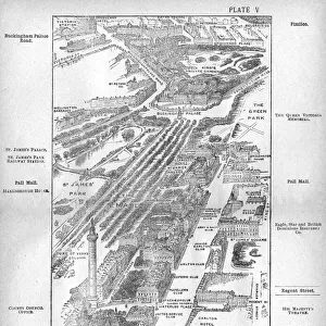
Scottsdale Arizona US City Street Map

![]()
Wall Art and Photo Gifts from Fine Art Storehouse
Scottsdale Arizona US City Street Map
Vector Illustration of a City Street Map of Scottsdale, Arizona, USA. Scale 1:60, 000.
All source data is in the public domain.
U.S. Geological Survey, US Topo
Used Layers:
USGS The National Map: National Hydrography Dataset (NHD)
USGS The National Map: National Transportation Dataset (NTD)
Unleash your creativity and transform your space into a visual masterpiece!
Frank Ramspott
Media ID 15055183
© Frank Ramspott, all rights reserved
Aerial View Arizona Computer Graphic Directly Above Gray Green Road Map Street Map Text Digitally Generated Image Scottsdale
FEATURES IN THESE COLLECTIONS
> Aerial Photography
> Related Images
> Animals
> Insects
> Hemiptera
> Green Scale
> Arts
> Landscape paintings
> Waterfall and river artworks
> River artworks
> Arts
> Portraits
> Pop art gallery
> Street art portraits
> Fine Art Storehouse
> Map
> Street Maps
> Fine Art Storehouse
> Map
> USA Maps
> Maps and Charts
> Geological Map
> North America
> United States of America
> Arizona
> Scottsdale
> North America
> United States of America
> Lakes
> Related Images
> North America
> United States of America
> Maps
EDITORS COMMENTS
This print showcases a meticulously detailed city street map of Scottsdale, Arizona, USA. With a scale of 1:60,000, every intricate aspect of the city's layout is beautifully illustrated in this vector illustration. The artist, Frank Ramspott, has skillfully utilized various layers from the USGS The National Map to create this stunning piece. The map incorporates essential features such as rivers, lakes, buildings, streets, and roads that make up the vibrant landscape of Scottsdale. Its design is digitally generated with an aerial view directly above the city. The color palette consists of shades of gray and green for land areas while blue represents water bodies. Crisp white text adds clarity to street names and other important information. As a result of utilizing public domain data sources like U. S Geological Survey (USGS) Topo maps along with their National Hydrography Dataset (NHD) and National Transportation Dataset (NTD), this artwork offers accuracy and reliability. With no people present in the image itself but rather focusing on cartography and physical geography elements only; it serves as both an informative tool for navigation purposes and a visually appealing work of art suitable for any space or decor style.
MADE IN THE USA
Safe Shipping with 30 Day Money Back Guarantee
FREE PERSONALISATION*
We are proud to offer a range of customisation features including Personalised Captions, Color Filters and Picture Zoom Tools
SECURE PAYMENTS
We happily accept a wide range of payment options so you can pay for the things you need in the way that is most convenient for you
* Options may vary by product and licensing agreement. Zoomed Pictures can be adjusted in the Cart.