Home > North America > United States of America > California > Fresno
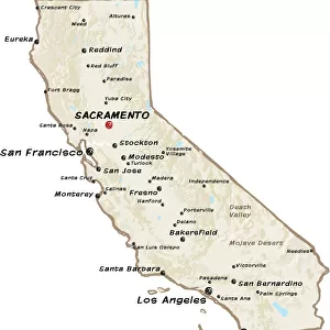
Fresno California US City Street Map

![]()
Wall Art and Photo Gifts from Fine Art Storehouse
Fresno California US City Street Map
Vector Illustration of a City Street Map of Fresno, California, USA. Scale 1:60, 000.
All source data is in the public domain.
U.S. Geological Survey, US Topo
Used Layers:
USGS The National Map: National Hydrography Dataset (NHD)
USGS The National Map: National Transportation Dataset (NTD)
Unleash your creativity and transform your space into a visual masterpiece!
Frank Ramspott
Media ID 15054925
© Frank Ramspott, all rights reserved
Aerial View Blue Color California Computer Graphic Directly Above Downtown Gray Color Road Map Street Map Text Digitally Generated Image Fresno Green Color White Color
FEATURES IN THESE COLLECTIONS
> Aerial Photography
> Related Images
> Animals
> Insects
> Hemiptera
> Green Scale
> Arts
> Landscape paintings
> Waterfall and river artworks
> River artworks
> Arts
> Portraits
> Pop art gallery
> Street art portraits
> Fine Art Storehouse
> Map
> Street Maps
> Fine Art Storehouse
> Map
> USA Maps
> Maps and Charts
> Geological Map
> North America
> United States of America
> California
> Fresno
> North America
> United States of America
> Lakes
> Related Images
> North America
> United States of America
> Maps
EDITORS COMMENTS
This vibrant and detailed print showcases the city streets of Fresno, California, USA. The vector illustration captures the essence of this bustling city, with its intricate road network and iconic landmarks. With a scale of 1:60,000, every street and building is meticulously depicted. The source data used to create this masterpiece is in the public domain, courtesy of the U. S. Geological Survey's National Map project. The layers utilized include the National Hydrography Dataset (NHD) and the National Transportation Dataset (NTD), ensuring accuracy and precision. From downtown to riverside areas, lakeshores to residential neighborhoods, this print encapsulates all aspects of Fresno's physical geography. The digitally generated image offers an aerial view directly above the cityscape, providing a unique perspective for map enthusiasts. The color palette adds depth to this visually striking piece - shades of gray represent roads while green signifies parks and open spaces. Blue hues depict water bodies such as rivers and lakes while white text labels various locations throughout Fresno. Created by talented artist Frank Ramspott exclusively for Fine Art Storehouse, this print is perfect for those who appreciate cartography or simply want a beautiful piece that celebrates their love for Fresno. Whether displayed in homes or offices, it serves as a reminder of the charm and vibrancy found within this remarkable city.
MADE IN THE USA
Safe Shipping with 30 Day Money Back Guarantee
FREE PERSONALISATION*
We are proud to offer a range of customisation features including Personalised Captions, Color Filters and Picture Zoom Tools
SECURE PAYMENTS
We happily accept a wide range of payment options so you can pay for the things you need in the way that is most convenient for you
* Options may vary by product and licensing agreement. Zoomed Pictures can be adjusted in the Cart.