Home > Europe > United Kingdom > Scotland > Strathclyde > Hamilton
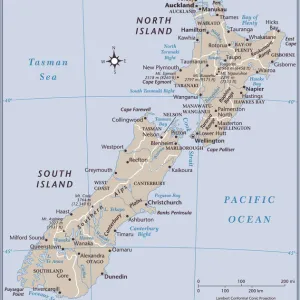
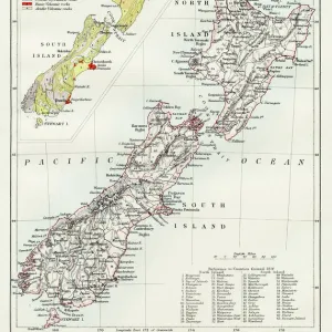
North Island Of New Zealand Vector Road Map

![]()
Poster Prints from Fine Art Storehouse
North Island Of New Zealand Vector Road Map
Detailed vector map of North Island Of New Zealand, including main cities, roads, rivers and lakes. The colors in the.eps-file are ready for print (CMYK). Included files are EPS (v10) and Hi-Res JPG (4922 x 4922 px)
Unleash your creativity and transform your space into a visual masterpiece!
Frank Ramspott
Media ID 14457409
© Frank Ramspott, all rights reserved
Auckland Circle Clip Art Computer Graphic Country Geographic Area Geography Gray Hastings Island Latitude Longitude New Zealand North Island Oceania Road Map Square Text Vector Wellington Digitally Generated Image Hamilton Napier
FEATURES IN THESE COLLECTIONS
> Arts
> Landscape paintings
> Waterfall and river artworks
> River artworks
> Arts
> Photorealistic artworks
> Detailed art pieces
> Masterful detailing in art
> Arts
> Street art graffiti
> Digital art
> Digital paintings
> Arts
> Street art graffiti
> Digital art
> Vector illustrations
> Europe
> United Kingdom
> Scotland
> Strathclyde
> Hamilton
> Maps and Charts
> Related Images
> Oceania
> New Zealand
> Auckland
> Oceania
> New Zealand
> Hamilton
> Oceania
> New Zealand
> Lakes
> Related Images
> Oceania
> New Zealand
> Maps
EDITORS COMMENTS
This stunning print captures the beauty and intricacy of the North Island of New Zealand. The detailed vector map showcases not only the main cities, roads, rivers, and lakes but also highlights the diverse geography of this enchanting region. With its ready-to-print colors in CMYK format, this. eps-file ensures a high-quality reproduction that will bring any space to life. The image portrays a digitally generated masterpiece that combines elements of design and cartography seamlessly. Its square shape adds a modern touch while emphasizing the travel destinations within this island. This vector illustration is devoid of people, allowing viewers to focus solely on the breathtaking landscapes and geographical features. The color palette includes shades of gray, red, and black which beautifully complement each other against the backdrop of coastal lines and seas. From Wellington to Auckland, Napier to Hamilton - all major cities are clearly marked with text labels for easy navigation. Whether you're an avid traveler or simply appreciate art inspired by nature's wonders, this print is sure to captivate your imagination. It serves as a reminder that New Zealand's North Island offers endless exploration opportunities for those seeking adventure or tranquility amidst its picturesque scenery. Created by Frank Ramspott exclusively for Fine Art Storehouse, this visually striking piece brings together technology and creativity in perfect harmony – making it an ideal addition to any home or office space.
MADE IN THE USA
Safe Shipping with 30 Day Money Back Guarantee
FREE PERSONALISATION*
We are proud to offer a range of customisation features including Personalised Captions, Color Filters and Picture Zoom Tools
SECURE PAYMENTS
We happily accept a wide range of payment options so you can pay for the things you need in the way that is most convenient for you
* Options may vary by product and licensing agreement. Zoomed Pictures can be adjusted in the Cart.