Home > North America > United States of America > Lakes > Lake Michigan
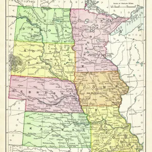
United States of America, States on Mississippi river, lithograph published 1878

![]()
Wall Art and Photo Gifts from Fine Art Storehouse
United States of America, States on Mississippi river, lithograph published 1878
United States of America, States on the Mississippi river. Lithograph, published in 1878
Unleash your creativity and transform your space into a visual masterpiece!
Media ID 13666821
© ZU_09
Arkansas Colorado Contour Drawing Country Geographic Area Gulf Coast States Illinois Image Date Iowa Lake Michigan Louisiana Minnesota Mississippi Mississippi River Missouri Nebraska North America Texas The Americas Topographic Map Topography Wisconsin Missouri River
FEATURES IN THESE COLLECTIONS
> Arts
> Landscape paintings
> Waterfall and river artworks
> River artworks
> Fine Art Storehouse
> Map
> Historical Maps
> Fine Art Storehouse
> Map
> USA Maps
> Maps and Charts
> Early Maps
> North America
> United States of America
> Arkansas
> Related Images
> North America
> United States of America
> Colorado
> Related Images
> North America
> United States of America
> Illinois
> Related Images
> North America
> United States of America
> Iowa
> Related Images
> North America
> United States of America
> Lakes
> Lake Michigan
> North America
> United States of America
> Louisiana
> Related Images
> North America
> United States of America
> Maps
EDITORS COMMENTS
This lithograph, published in 1878, offers a glimpse into the rich history and topography of the United States of America. The image showcases the states situated along the majestic Mississippi River, presenting an antique engraved view that takes us back to a bygone era. The vertical composition beautifully captures the country's geographic area, stretching from North Dakota down to Louisiana and Mississippi on the Gulf Coast. Each state is meticulously depicted with intricate contour drawings, allowing us to appreciate their unique shapes and sizes. From Colorado to Texas, Illinois to Nebraska, Wisconsin to Missouri - this map presents a comprehensive overview of these federal states. As our eyes wander across this old lithograph, we are drawn towards two prominent bodies of water: Lake Michigan and the mighty Mississippi River itself. These natural features not only shaped the landscape but also played significant roles in transportation and trade during that time period. While no people are present in this particular photograph print from 2015, it serves as a reminder of how much has changed since its creation over 140 years ago. It invites us to reflect on our nation's past while appreciating its enduring beauty and diverse geography. This stunning piece is sure to captivate history enthusiasts and cartography aficionados alike with its timeless charm.
MADE IN THE USA
Safe Shipping with 30 Day Money Back Guarantee
FREE PERSONALISATION*
We are proud to offer a range of customisation features including Personalised Captions, Color Filters and Picture Zoom Tools
SECURE PAYMENTS
We happily accept a wide range of payment options so you can pay for the things you need in the way that is most convenient for you
* Options may vary by product and licensing agreement. Zoomed Pictures can be adjusted in the Cart.