Home > Arts > Landscape paintings > Waterfall and river artworks > River artworks
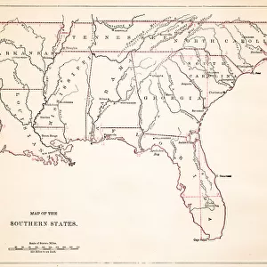
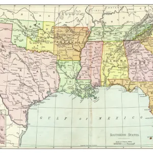
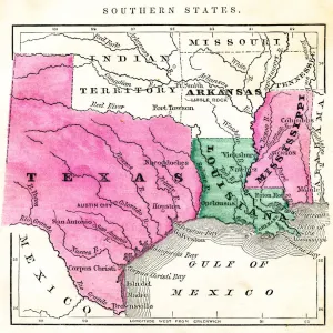
Southern States 1852 Map

![]()
Wall Art and Photo Gifts from Fine Art Storehouse
Southern States 1852 Map
Unleash your creativity and transform your space into a visual masterpiece!
benoitb
Media ID 13666911
© benoitb
Alabama Arkansas Atlantic Ocean Color Swatch Florida Us State Florida Usa Geographic Map Gulf Coast States Illinois Indiana Kentucky Line Art Louisiana Maryland Maryland State Mississippi Mississippi River Missouri North Carolina North Carolina Us State Ohio Sketch South Carolina Southern Usa State Tennessee The Americas Us State Border Virginia Virginia Us State Classical Style Drawing Art Product Painted Image Retro Styled Victorian Style
FEATURES IN THESE COLLECTIONS
> Arts
> Landscape paintings
> Waterfall and river artworks
> River artworks
> Fine Art Storehouse
> Map
> Historical Maps
> Fine Art Storehouse
> Map
> USA Maps
> USA Southern States Historical Maps
> Fine Art Storehouse
> Map
> USA Maps
> Maps and Charts
> Early Maps
> North America
> United States of America
> Alabama
> Related Images
> North America
> United States of America
> Arkansas
> Related Images
> North America
> United States of America
> Florida
> Related Images
> North America
> United States of America
> Illinois
> Related Images
> North America
> United States of America
> Indiana
> Related Images
> North America
> United States of America
> Kentucky
> Related Images
> North America
> United States of America
> Lakes
> Related Images
EDITORS COMMENTS
This print takes us back in time to the year 1852, offering a glimpse into the intricate cartography of the Southern States. With its retro and antique charm, this 19th-century-style map is a true work of art. The artist's attention to detail is evident in every stroke, as they skillfully painted and engraved each state and geographic feature. The print showcases a classical Victorian style that transports us to an era where physical geography was meticulously documented. From Florida to Illinois, Ohio to Indiana, Missouri to Maryland, Virginia to South Carolina, North Carolina to Louisiana - all these states are beautifully illustrated with vibrant color swatches. As we explore this historical masterpiece further, our eyes are drawn towards the majestic Atlantic Ocean and the meandering Mississippi River. These natural landmarks add depth and character to the overall composition. With its rich history and cultural significance, this map serves as both an educational tool and a decorative piece for any space. Whether hung on a wall or displayed on a desk, it invites us to appreciate the craftsmanship of old-world cartographers while providing valuable insights into America's southern region during that time period. Benoitb has truly captured the essence of this era through his masterful illustration skills. This print is not only an artistic representation but also a testament to our fascination with maps as timeless artifacts that connect us with our past.
MADE IN THE USA
Safe Shipping with 30 Day Money Back Guarantee
FREE PERSONALISATION*
We are proud to offer a range of customisation features including Personalised Captions, Color Filters and Picture Zoom Tools
SECURE PAYMENTS
We happily accept a wide range of payment options so you can pay for the things you need in the way that is most convenient for you
* Options may vary by product and licensing agreement. Zoomed Pictures can be adjusted in the Cart.