Home > North America > United States of America > New York > New York > Maps
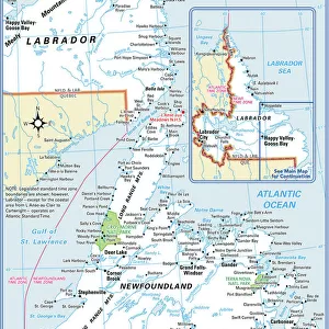
Newfoundland map 1884

![]()
Wall Art and Photo Gifts from Fine Art Storehouse
Newfoundland map 1884
Encyclopedia Britannica 9th Edition New York Charles Scribners and Sonsl 1884 Vol XVII
Unleash your creativity and transform your space into a visual masterpiece!
THEPALMER
Media ID 14756688
© This content is subject to copyright
FEATURES IN THESE COLLECTIONS
> Fine Art Storehouse
> Map
> Historical Maps
> Maps and Charts
> Early Maps
> North America
> Canada
> Maps
> North America
> United States of America
> New York
> New York
> Maps
EDITORS COMMENTS
This print showcases a historical treasure, the Newfoundland map from the 1884 Encyclopedia Britannica's 9th Edition. A true testament to the art of cartography, this exquisite piece takes us back in time to an era when exploration and discovery were at their peak. The intricate details and precision with which this map was crafted are truly awe-inspiring. The Newfoundland map encompasses not only its namesake province but also regions such as Labrador, Quebec, and Canada as a whole. Its rich colors and fine lines bring life to the diverse landscapes that make up this vast territory. From rugged coastlines to sprawling forests, one can almost feel the adventurous spirit that must have filled those who first set foot on these lands. Expertly preserved by THEPALMER, this print allows us to marvel at both the beauty of nature and human ingenuity. It serves as a reminder of our collective history and how far we have come since those early days of exploration. Whether you are a history enthusiast or simply appreciate fine art, this remarkable piece is sure to captivate your imagination. Let yourself be transported through time with this stunning Newfoundland map from 1884 - an extraordinary addition for any collector or lover of vintage treasures.
MADE IN THE USA
Safe Shipping with 30 Day Money Back Guarantee
FREE PERSONALISATION*
We are proud to offer a range of customisation features including Personalised Captions, Color Filters and Picture Zoom Tools
SECURE PAYMENTS
We happily accept a wide range of payment options so you can pay for the things you need in the way that is most convenient for you
* Options may vary by product and licensing agreement. Zoomed Pictures can be adjusted in the Cart.