Home > Europe > France > Canton > Maine
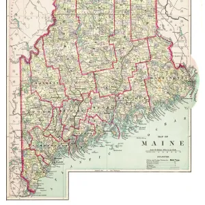
Map of Maine 1877

![]()
Wall Art and Photo Gifts from Fine Art Storehouse
Map of Maine 1877
Warrens Common School Geography 1877
Unleash your creativity and transform your space into a visual masterpiece!
THEPALMER
Media ID 18356661
FEATURES IN THESE COLLECTIONS
> Europe
> France
> Canton
> Maine
> Fine Art Storehouse
> Map
> Historical Maps
> Maps and Charts
> Early Maps
EDITORS COMMENTS
In this print titled "Map of Maine 1877 (Warrens Common School Geography 1877) (956756842) by THEPALMER" we are transported back in time to the year 1877, where a beautifully intricate map of Maine unfolds before our eyes. This vintage piece, sourced from Fine Art Storehouse, offers a glimpse into the past and allows us to appreciate the artistry and craftsmanship that went into cartography during this era. The Map of Maine showcases an impressive level of detail, meticulously outlining every river, lake, town, and county within its borders. The delicate lines and elegant typography evoke a sense of nostalgia for a time when maps were not just functional tools but also works of art. As we examine this historical artifact closely, it becomes evident that it was intended for educational purposes. Labeled as part of Warrens Common School Geography series from 1877, one can imagine how students in classrooms across America would have eagerly absorbed knowledge about their country's geography using similar maps. THEPALMER has expertly captured this timeless piece with precision and care. The high-quality print ensures that every minute detail is faithfully reproduced on fine art paper. Whether displayed in a classroom or adorning the walls of an avid history enthusiast's study room or office space, this photograph invites viewers to embark on a journey through time while appreciating the beauty inherent in both cartography and photography itself.
MADE IN THE USA
Safe Shipping with 30 Day Money Back Guarantee
FREE PERSONALISATION*
We are proud to offer a range of customisation features including Personalised Captions, Color Filters and Picture Zoom Tools
SECURE PAYMENTS
We happily accept a wide range of payment options so you can pay for the things you need in the way that is most convenient for you
* Options may vary by product and licensing agreement. Zoomed Pictures can be adjusted in the Cart.