Home > Europe > United Kingdom > England > Leicester
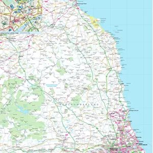
Map of the City of Bradgate, England Victorian Engraving, 1840

![]()
Wall Art and Photo Gifts from Fine Art Storehouse
Map of the City of Bradgate, England Victorian Engraving, 1840
Very Rare, Beautifully Illustrated Antique Engraving of Map of the Map of the City of Bradgate, England Victorian Engraving, 1840. Source: Original edition from my own archives. Copyright has expired on this artwork. Digitally restored
Unleash your creativity and transform your space into a visual masterpiece!
bauhaus1000
Media ID 13667295
© This content is subject to copyright
1800s British Culture Chart Diagram Direction Graph Great Britain Leicester Non Us Location Plan Residential District Thoroughfare Village Drawing Art Product Victorian Style
FEATURES IN THESE COLLECTIONS
> Arts
> Landscape paintings
> Waterfall and river artworks
> River artworks
> Arts
> Portraits
> Pop art gallery
> Street art portraits
> Europe
> United Kingdom
> England
> Leicester
> Europe
> United Kingdom
> England
> Maps
> Europe
> United Kingdom
> England
> Rivers
> Europe
> United Kingdom
> Maps
> Fine Art Storehouse
> Map
> Historical Maps
> Fine Art Storehouse
> Map
> USA Maps
> Maps and Charts
> Early Maps
> North America
> United States of America
> Maps
EDITORS COMMENTS
This rare and beautifully illustrated antique engraving captures the essence of Bradgate, England in the Victorian era. Dating back to 1840, this map provides a fascinating glimpse into the city's history and architectural layout. The detailed illustration showcases the town's streets, river, and thoroughfares, allowing viewers to navigate through its charming British culture. With its intricate design and Victorian style, this print is a true work of art that transports us back to a bygone era. Digitally restored from an original edition found in my personal archives, this artwork holds historical significance as it reflects the 19th-century cartography techniques used at that time. The etching and engraving techniques employed give depth and character to every line on this map. As you explore this print further, you'll notice how it highlights not only Bradgate's urban areas but also its residential districts and surrounding villages. This comprehensive depiction offers an invaluable resource for historians or those with a keen interest in local history. Whether you're an avid collector or simply appreciate fine art products with historical value, this Map of the City of Bradgate will undoubtedly become a cherished addition to your collection. Its timeless appeal transcends borders as it captures the essence of British heritage while providing insight into life during the 19th century.
MADE IN THE USA
Safe Shipping with 30 Day Money Back Guarantee
FREE PERSONALISATION*
We are proud to offer a range of customisation features including Personalised Captions, Color Filters and Picture Zoom Tools
FREE COLORIZATION SERVICE
You can choose advanced AI Colorization for this picture at no extra charge!
SECURE PAYMENTS
We happily accept a wide range of payment options so you can pay for the things you need in the way that is most convenient for you
* Options may vary by product and licensing agreement. Zoomed Pictures can be adjusted in the Cart.