Home > Asia > Malaysia > Maps
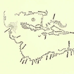
Early Map of Dutch Navigation, Victorian Illustration

![]()
Wall Art and Photo Gifts from Fine Art Storehouse
Early Map of Dutch Navigation, Victorian Illustration
Very Rare, Beautifully Illustrated Antique Engraved Victorian Illustration of Early Map of Dutch Navigation. Copyright has expired on this artwork. Digitally restored
Unleash your creativity and transform your space into a visual masterpiece!
bauhaus1000
Media ID 13667013
© bauhaus1000
16th Century 16th Century Style 268399 78273 Business Finance And Industry Chart Design Element Direction Dutch Culture European Culture Exploration Explorer Freight Transportation Image Created 16th Century Indonesia Industry Island Island Of Borneo Journey Malaysia Netherlands Pacific Ocean Pattern Sailing Sea Passage Ship Shipping South China Sea Sumatra Sumatra Indonesia Victorian Style
FEATURES IN THESE COLLECTIONS
> Europe
> Netherlands
> Maps
> Fine Art Storehouse
> Map
> Historical Maps
> Maps and Charts
> Early Maps
> Maps and Charts
> Netherlands
EDITORS COMMENTS
This beautifully illustrated antique engraving takes us back to the 16th century, showcasing an early map of Dutch navigation. With its intricate details and Victorian style, this print is a rare find that captures the essence of European culture during that era. The image depicts a white background with a mesmerizing cartography design featuring the Island of Borneo and sea passages. It transports us to a time when shipping and exploration were at their peak, as brave explorers set sail in search of new lands. The black and white engraved image showcases the island's strategic location between Malaysia, Sumatra, Indonesia, and Asia. The Dutch influence is evident as they navigated through these waters on their journey towards establishing trade routes in the region. As we delve into this historical artifact, we are reminded of how maps played a crucial role in shaping our understanding of the world centuries ago. This particular piece serves as both an educational tool and a work of art that encapsulates Dutch culture from that period. Digitally restored to its former glory after years gone by since it was first created in the 16th century, this print offers us a glimpse into history while adding an elegant touch to any space it adorns. A true testament to human curiosity and exploration, this antique engraving invites us to embark on our own voyage through time.
MADE IN THE USA
Safe Shipping with 30 Day Money Back Guarantee
FREE PERSONALISATION*
We are proud to offer a range of customisation features including Personalised Captions, Color Filters and Picture Zoom Tools
SECURE PAYMENTS
We happily accept a wide range of payment options so you can pay for the things you need in the way that is most convenient for you
* Options may vary by product and licensing agreement. Zoomed Pictures can be adjusted in the Cart.