Fraud Blocker Skip to main content

Home > North America > United States of America > New York > New York > Maps
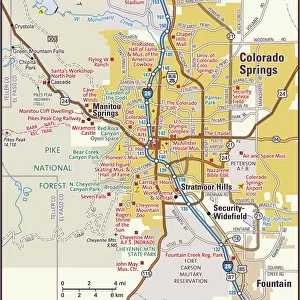
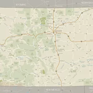
Colorado map 1893

Colorado map 1893


Framed Photos
Photo Prints
Jigsaw Puzzles
Poster Prints
Canvas Prints
Fine Art Prints
Metal Prints
Home Decor


We accept all major credit cards

Fine Art Storehouse

Wall Art and Photo Gifts from Fine Art Storehouse

Colorado map 1893

Johnsonas Universal Cyclopedia - Charles Kendall - New York 1893 vol 2

Unleash your creativity and transform your space into a visual masterpiece!

THEPALMER

Media ID 14756548

© This content is subject to copyright

Colorado


FEATURES IN THESE COLLECTIONS

> Fine Art Storehouse > Map > Historical Maps

> Fine Art Storehouse > Map > USA Maps

> Fine Art Storehouse > Map

> Maps and Charts > Early Maps

> North America > United States of America > Colorado > Related Images

> North America > United States of America > Maps

> North America > United States of America > New York > New York > Maps


EDITORS COMMENTS
In this print titled "Colorado map 1893" we are transported back in time to the late 19th century, where cartography was a true art form. The image showcases a meticulously detailed map of Colorado, extracted from Johnson's Universal Cyclopedia by Charles Kendall, published in New York in 1893. The map itself is a testament to the dedication and precision of its creator. Every contour line, river, and mountain range has been intricately drawn with utmost care. It provides us with an invaluable glimpse into the historical geography of Colorado during that era. As we explore this vintage masterpiece further, it becomes apparent that it not only serves as a navigational tool but also as a visual representation of the state's rich heritage. The faded hues and delicate lines evoke a sense of nostalgia for simpler times when exploration and discovery were at their peak. "The Palmer" the talented artist behind this remarkable print available through Fine Art Storehouse, has skillfully captured every detail with exceptional clarity. From afar, one can appreciate the overall composition and beauty of this historic piece; however, upon closer inspection, each intricate element comes alive. Whether you have an affinity for history or simply admire fine craftsmanship, "Colorado map 1893" is sure to captivate your imagination while serving as a timeless reminder of our ever-evolving world.

MADE IN THE USA
Safe Shipping with 30 Day Money Back Guarantee

FREE PERSONALISATION*
We are proud to offer a range of customisation features including Personalised Captions, Color Filters and Picture Zoom Tools

SECURE PAYMENTS
We happily accept a wide range of payment options so you can pay for the things you need in the way that is most convenient for you

* Options may vary by product and licensing agreement. Zoomed Pictures can be adjusted in the Cart.


redeem
Beautiful Photo Prints and Gifts
image
Professionally Printed
inventory
Photo Prints are in stock
thumb_up
Professional quality finish
diamond
Made with high-grade materials
inventory_2
Carefully packed to aid safe arrival


Related Images


Colorado Springs area map
Pikes Peak Avenue, Colorado Springs
Pikes Peak Avenue. ca. 1937, Colorado Springs, Colorado, USA, 539-Pikes Peak (Alt. 14, 110 Ft. ) from Pikes Peak Avenue, Colorado Springs, (Alt. 6, 072 Ft. ), Colorado. Pikes Peak Avenue is a broad and stately street pointing directly toward the Peak from which it is named that looms above it. At the west it terminates at the Antlers Hotel whose graceful towers form a perfect sight like those on a rifle for the view of Pikes Peak. In the summer season it is thronged with visitors of every station in life from every state and country, for the Avenue is the center of tourist activity. Few who have traversed its broad pavements will forget it as it is one of the most impressive street spectacles in the world
Colorado Springs and Pikes Peak, Colorado, USA
The Marina District with the Golden Gate, San Francisco, California, USA
Morning light bathes the Golden Gate Bridge & Fort Point
Night view, Colorado Springs, Colorado, USA
St Marys Abbey, York N110165
Madrid, Spain, Europe
Waning gibbous Moon
Waning gibbous Moon
Montana Washington Oregon Idaho map 1881
Colorado Map
Colorado Map

+

Shipping

+

Choices

+

Reviews

+

Guaranteed


Related Collections


Early Maps
Early Maps
Browse 24,907 Prints
Map
Map
Browse 9,856 Prints
Colorado Related Images
Browse 1,673 Prints
Maps
Maps
Browse 4,129 Prints
Maps
Maps
Browse 2,519 Prints
USA Maps
USA Maps
Browse 722 Prints
Historical Maps
Historical Maps
Browse 3,307 Prints