Home > Fine Art Storehouse > Map
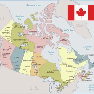
Canada map 1893

![]()
Wall Art and Photo Gifts from Fine Art Storehouse
Canada map 1893
Johnsonas Universal Cyclopedia - Charles Kendall - New York 1893 vol 2
Unleash your creativity and transform your space into a visual masterpiece!
THEPALMER
Media ID 14756554
© This content is subject to copyright
FEATURES IN THESE COLLECTIONS
> Fine Art Storehouse
> Map
> Historical Maps
EDITORS COMMENTS
This print showcases a historical gem, the "Canada map 1893" sourced from Johnson's Universal Cyclopedia by Charles Kendall. Immerse yourself in the rich tapestry of Canadian history as you explore this meticulously detailed cartographic masterpiece. The map, originating from New York in 1893, offers a fascinating glimpse into Canada's past and its place within North America. Every contour and boundary is intricately depicted, allowing viewers to trace their fingers along each province and territory. From the vast wilderness of British Columbia to the rugged coastlines of Newfoundland and Labrador, this vintage map transports us back to an era when exploration was paramount. The sepia-toned hues lend an air of nostalgia to the print, evoking a sense of timelessness that resonates with both history enthusiasts and art aficionados alike. As you gaze upon this piece, allow your imagination to wander through bustling cities like Toronto or Montreal while simultaneously appreciating the untouched beauty found in remote regions such as Yukon or Nunavut. "The Palmer" has masterfully captured this historic artifact with impeccable attention to detail. Whether displayed proudly on your office wall or adorning your living room space, this fine art print will undoubtedly spark conversations about Canada's heritage for years to come.
MADE IN THE USA
Safe Shipping with 30 Day Money Back Guarantee
FREE PERSONALISATION*
We are proud to offer a range of customisation features including Personalised Captions, Color Filters and Picture Zoom Tools
SECURE PAYMENTS
We happily accept a wide range of payment options so you can pay for the things you need in the way that is most convenient for you
* Options may vary by product and licensing agreement. Zoomed Pictures can be adjusted in the Cart.