Home > South America > Paraguay > Maps
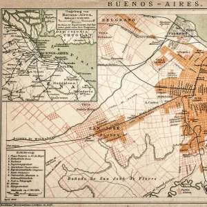
Argentina Chile Urugay map 1867

![]()
Wall Art and Photo Gifts from Fine Art Storehouse
Argentina Chile Urugay map 1867
Mitchellas Modern Atlas - Published by E.H. Butler and Co - Philadelphia 1867
Unleash your creativity and transform your space into a visual masterpiece!
THEPALMER
Media ID 13609193
© This content is subject to copyright
Argentina Chile Paraguay Patagonia Patagonia Argentina South America Uruguay
FEATURES IN THESE COLLECTIONS
> Fine Art Storehouse
> Map
> Historical Maps
> Fine Art Storehouse
> Travel Imagery
> Travel Destinations
> patagonia
> Maps and Charts
> Early Maps
> North America
> United States of America
> Maps
> South America
> Argentina
> Maps
> South America
> Chile
> Maps
> South America
> Paraguay
> Maps
> South America
> Uruguay
> Maps
EDITORS COMMENTS
This print showcases a historical gem, the "Argentina Chile Uruguay map 1867". Published by E. H. Butler and Co in Philadelphia during that era, this piece is a testament to the intricate art of cartography. The image depicts an exquisite engraving and etching illustration, skillfully crafted with meticulous detail. The map itself encompasses not only Argentina, Chile, and Uruguay but also Paraguay and Patagonia in South America. Its vertical orientation allows for a comprehensive view of these countries' physical geography. As one gazes upon this antique lithograph, they are transported back in time to an era when maps were cherished possessions. The artist behind this masterpiece remains unknown; however, their work has stood the test of time as it continues to captivate viewers even today. The fine craftsmanship evident in every line and contour highlights the dedication put into creating such detailed representations of landmasses. "The Argentina Chile Uruguay map 1867" offers us a glimpse into history's geographical landscape while reminding us of the importance placed on accurate cartographic depictions during that period. This print from Fine Art Storehouse serves as both an educational tool for enthusiasts interested in exploring past territories and a stunning decorative piece that adds depth to any space it graces.
MADE IN THE USA
Safe Shipping with 30 Day Money Back Guarantee
FREE PERSONALISATION*
We are proud to offer a range of customisation features including Personalised Captions, Color Filters and Picture Zoom Tools
SECURE PAYMENTS
We happily accept a wide range of payment options so you can pay for the things you need in the way that is most convenient for you
* Options may vary by product and licensing agreement. Zoomed Pictures can be adjusted in the Cart.