Home > North America > United States of America > New York > New York > Maps
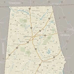
Alabama map 1878

![]()
Wall Art and Photo Gifts from Fine Art Storehouse
Alabama map 1878
Encyclopedia Britannica 9th Edition Vol I New York, Samuel Hall 1878
Unleash your creativity and transform your space into a visual masterpiece!
THEPALMER
Media ID 13609271
© This content is subject to copyright
Alabama Gulf Coast States North America
FEATURES IN THESE COLLECTIONS
> Fine Art Storehouse
> Map
> Historical Maps
> Fine Art Storehouse
> Map
> USA Maps
> Maps and Charts
> Early Maps
> North America
> United States of America
> Alabama
> Related Images
> North America
> United States of America
> Maps
> North America
> United States of America
> New York
> New York
> Maps
EDITORS COMMENTS
In this print titled "Alabama Map 1878" we are transported back in time to the late 19th century, where cartography was a meticulous art form. The image showcases an exquisite engraving and etching of Alabama's physical geography as depicted in the Encyclopedia Britannica 9th Edition Volume I, published by Samuel Hall in New York. The antique lithograph captures the intricate details of Alabama's landscape with remarkable precision. From its vertical orientation, we can appreciate the Gulf Coast states' proximity and their influence on Alabama's geographical features. The map serves as a window into history, offering us a glimpse into how our understanding of North America has evolved over time. The craftsmanship evident in this illustration is truly awe-inspiring. Each line and contour meticulously etched onto paper tells a story about the people who inhabited these lands long ago. As we explore every inch of this map, it becomes apparent that it not only provides valuable geographic information but also serves as an artistic masterpiece. "The Palmer" from Fine Art Storehouse has skillfully captured this historic piece, allowing us to bring home a tangible connection to our past. Whether displayed for educational purposes or simply admired for its aesthetic beauty, this print invites us to reflect upon the rich heritage embedded within Alabama's borders while appreciating the timeless artistry behind its creation.
MADE IN THE USA
Safe Shipping with 30 Day Money Back Guarantee
FREE PERSONALISATION*
We are proud to offer a range of customisation features including Personalised Captions, Color Filters and Picture Zoom Tools
SECURE PAYMENTS
We happily accept a wide range of payment options so you can pay for the things you need in the way that is most convenient for you
* Options may vary by product and licensing agreement. Zoomed Pictures can be adjusted in the Cart.