Home > North America > United States of America > New York > New York > Maps
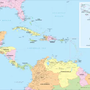
West Indies map of 1869

![]()
Wall Art and Photo Gifts from Fine Art Storehouse
West Indies map of 1869
Cornells Grammar School Geography By S.S. Cornell - New York 1869
Unleash your creativity and transform your space into a visual masterpiece!
THEPALMER
Media ID 18106795
© 2014 Roberto Adrian Photography
FEATURES IN THESE COLLECTIONS
> Fine Art Storehouse
> Map
> Historical Maps
> Maps and Charts
> Early Maps
> North America
> United States of America
> New York
> New York
> Maps
EDITORS COMMENTS
This print takes us back in time to the year 1869, when the West Indies map was meticulously crafted by S. S. Cornell for his renowned Grammar School Geography book. The map, now a historical relic, showcases the intricate details and artistry that went into cartography during this era. The rich hues of sepia and aged paper lend an air of authenticity to this fine art piece from THEPALMER collection at Fine Art Storehouse. Every contour line, island shape, and coastal feature is delicately etched onto the surface, offering a glimpse into how these islands were perceived over a century ago. As we gaze upon this vintage treasure, our imagination is transported to a time when explorers set sail across vast oceans in search of new lands and untold adventures. We can almost feel the excitement they must have felt as they discovered each unique island on their journey through these tropical waters. Beyond its historical significance lies an aesthetic appeal that captivates viewers with its antique charm. This photograph print serves as a reminder of how maps were once cherished objects that not only guided travelers but also adorned walls as works of art. Whether you are an avid historian or simply appreciate beautiful craftsmanship, this West Indies map print will undoubtedly add character and intrigue to any space it graces. Let it be a conversation starter or serve as inspiration for your own wanderlust-filled dreams; either way, it promises to transport you back in time with every glance.
MADE IN THE USA
Safe Shipping with 30 Day Money Back Guarantee
FREE PERSONALISATION*
We are proud to offer a range of customisation features including Personalised Captions, Color Filters and Picture Zoom Tools
SECURE PAYMENTS
We happily accept a wide range of payment options so you can pay for the things you need in the way that is most convenient for you
* Options may vary by product and licensing agreement. Zoomed Pictures can be adjusted in the Cart.