Home > North America > United States of America > New York > New York > Maps
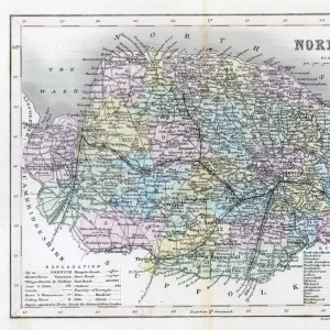
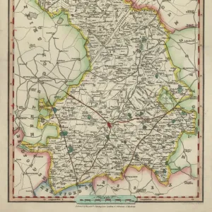
Norfolk map 1884

![]()
Wall Art and Photo Gifts from Fine Art Storehouse
Norfolk map 1884
Encyclopedia Britannica 9th Edition New York Charles Scribners and Sonsl 1884 Vol XVII
Unleash your creativity and transform your space into a visual masterpiece!
THEPALMER
Media ID 14549449
© This content is subject to copyright
FEATURES IN THESE COLLECTIONS
> Europe
> United Kingdom
> England
> Maps
> Europe
> United Kingdom
> England
> Norfolk
> Related Images
> Europe
> United Kingdom
> England
> Suffolk
> Related Images
> Europe
> United Kingdom
> England
> York
> Europe
> United Kingdom
> Maps
> Fine Art Storehouse
> Map
> Historical Maps
> Maps and Charts
> Early Maps
> North America
> United States of America
> New York
> New York
> Maps
EDITORS COMMENTS
This print titled "Norfolk map 1884" takes us on a nostalgic journey back in time to the late 19th century. The image showcases an intricately detailed map from the Encyclopedia Britannica's 9th Edition, published in New York by Charles Scribners and Sons in 1884. Vol XVII of this esteemed encyclopedia offers a fascinating glimpse into the geography of England, specifically Norfolk and Suffolk. The map itself is a testament to the artistry and craftsmanship of cartographers during that era. Every contour, river, town, and village is meticulously depicted with precision and accuracy. It serves as both a historical record and a work of art. As we delve into this piece by THEPALMER from Fine Art Storehouse, we are transported to rural England where rolling hills meet picturesque countryside dotted with charming hamlets. The intricate details invite us to explore every nook and cranny of these two counties. Whether you have personal ties to Norfolk or Suffolk or simply appreciate vintage maps as pieces of history, this print will undoubtedly captivate your imagination. Its timeless appeal makes it perfect for any space - be it an office adorned with antiques or a modern living room seeking an elegant touch. Allow yourself to get lost within its lines; let it spark conversations about heritage, exploration, or even inspire dreams of embarking on your own adventure through these enchanting English landscapes captured so beautifully over a century ago.
MADE IN THE USA
Safe Shipping with 30 Day Money Back Guarantee
FREE PERSONALISATION*
We are proud to offer a range of customisation features including Personalised Captions, Color Filters and Picture Zoom Tools
SECURE PAYMENTS
We happily accept a wide range of payment options so you can pay for the things you need in the way that is most convenient for you
* Options may vary by product and licensing agreement. Zoomed Pictures can be adjusted in the Cart.