Home > North America > United States of America > New York > New York > Maps
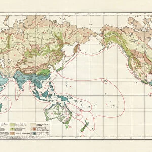
Map of the world 1895

![]()
Wall Art and Photo Gifts from Fine Art Storehouse
Map of the world 1895
The Rand-McNally Grammar School Geography 1895 - Chicago & New York
Unleash your creativity and transform your space into a visual masterpiece!
THEPALMER
Media ID 14824605
© This content is subject to copyright
FEATURES IN THESE COLLECTIONS
> Fine Art Storehouse
> Map
> Historical Maps
> Maps and Charts
> Early Maps
> Maps and Charts
> World
> North America
> United States of America
> New York
> New York
> Maps
EDITORS COMMENTS
In this print titled "Map of the World 1895" we are transported back in time to a bygone era when cartography was both an art form and a scientific endeavor. The map, originally published in "The Rand-McNally Grammar School Geography 1895" in Chicago and New York, exudes an air of nostalgia and curiosity. As our eyes wander across the intricate details of this vintage masterpiece, we are reminded of the vastness and diversity that our planet holds. Every contour, every line represents not only geographical boundaries but also stories waiting to be discovered. It is as if each country has its own unique personality, inviting us to embark on a journey through time. The craftsmanship evident in this print is truly remarkable; it reflects the meticulous efforts put forth by early cartographers who painstakingly documented every inch of landmass with precision. The faded colors add a touch of antiquity, reminding us that maps like these were once treasured possessions used for exploration or educational purposes. "The Map of the World 1895" transports us beyond mere geography; it evokes a sense of wonderment about how much our world has changed since then. It serves as a reminder that while borders may shift over time, our shared humanity remains constant. This Fine Art Storehouse print by THEPALMER allows us to bring home a piece of history – an exquisite snapshot frozen in time – igniting conversations about past adventures and inspiring future explorations.
MADE IN THE USA
Safe Shipping with 30 Day Money Back Guarantee
FREE PERSONALISATION*
We are proud to offer a range of customisation features including Personalised Captions, Color Filters and Picture Zoom Tools
SECURE PAYMENTS
We happily accept a wide range of payment options so you can pay for the things you need in the way that is most convenient for you
* Options may vary by product and licensing agreement. Zoomed Pictures can be adjusted in the Cart.