Home > North America > United States of America > Maps
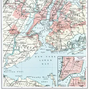
Map Middle Atlantic States USA 1888

![]()
Wall Art and Photo Gifts from Fine Art Storehouse
Map Middle Atlantic States USA 1888
Butlers Elementary Geography by Jacques W. Redway - Philadelphia 1888
Unleash your creativity and transform your space into a visual masterpiece!
THEPALMER
Media ID 20114767
© A 2014 Roberto Adrian Photography
FEATURES IN THESE COLLECTIONS
> Fine Art Storehouse
> Map
> Historical Maps
> Fine Art Storehouse
> Map
> USA Maps
> Maps and Charts
> Early Maps
> North America
> United States of America
> Maps
EDITORS COMMENTS
This print takes us back in time to the year 1888, where we find ourselves immersed in a world of exploration and discovery. The "Map Middle Atlantic States USA 1888" is a remarkable piece from Jacques W. Redway's renowned work, "Butlers Elementary Geography". As we gaze upon this vintage map, our eyes are immediately drawn to the intricate details and craftsmanship that went into its creation. The map showcases the Middle Atlantic states of the United States during a pivotal era in American history. From Pennsylvania to New York, New Jersey to Delaware, Maryland to Virginia - each state is meticulously outlined with precision and accuracy. It serves as a testament to Redway's dedication towards providing an educational resource for students of his time. Through this print, we can almost feel the excitement that must have filled classrooms across Philadelphia when this geography textbook was first introduced. Its purpose was not only to educate but also ignite curiosity about these fascinating regions within young minds. "The Map Middle Atlantic States USA 1888" by THEPALMER transports us back over a century ago, reminding us of how far we've come while honoring the rich heritage that has shaped our present-day understanding of geography. This stunning artwork serves as both an aesthetic delight and an invaluable historical artifact for those who appreciate fine art and seek knowledge about America's past.
MADE IN THE USA
Safe Shipping with 30 Day Money Back Guarantee
FREE PERSONALISATION*
We are proud to offer a range of customisation features including Personalised Captions, Color Filters and Picture Zoom Tools
SECURE PAYMENTS
We happily accept a wide range of payment options so you can pay for the things you need in the way that is most convenient for you
* Options may vary by product and licensing agreement. Zoomed Pictures can be adjusted in the Cart.