Home > North America > United States of America > Maps
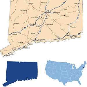
Map of Connecticut 1877

![]()
Wall Art and Photo Gifts from Fine Art Storehouse
Map of Connecticut 1877
Warrens Common School Geography 1877
Unleash your creativity and transform your space into a visual masterpiece!
THEPALMER
Media ID 14824549
© This content is subject to copyright
Connecticut Middlesex New London
FEATURES IN THESE COLLECTIONS
> Europe
> United Kingdom
> England
> London
> Related Images
> Europe
> United Kingdom
> England
> Middlesex
> Related Images
> Fine Art Storehouse
> Map
> Historical Maps
> Fine Art Storehouse
> Map
> USA Maps
> Maps and Charts
> Early Maps
> North America
> United States of America
> Connecticut
> Related Images
> North America
> United States of America
> Maps
EDITORS COMMENTS
This print titled "Map of Connecticut 1877 (Warrens Common School Geography 1877)" takes us on a nostalgic journey back to the late 19th century. Created by THEPALMER and available at Fine Art Storehouse, this intricate map showcases the state of Connecticut in all its historical glory. The attention to detail is remarkable as every county, town, and city is meticulously labeled, allowing us to explore the geography of this northeastern gem. From Middlesex to New London and Windham, each region comes alive through delicate lines and vibrant colors that transport us to a time long gone. As we gaze upon this vintage masterpiece, it sparks our curiosity about how life must have been during that era. We can almost imagine horse-drawn carriages traversing these roads or bustling communities thriving along the coastlines. This map serves as a window into history, reminding us of Connecticut's rich heritage and its significance in shaping America's past. Whether you are an avid historian or simply appreciate art with a touch of nostalgia, "Map of Connecticut 1877" will undoubtedly captivate your imagination. Hang it proudly on your wall or gift it to someone who cherishes both history and aesthetics – either way, it will be cherished for years to come.
MADE IN THE USA
Safe Shipping with 30 Day Money Back Guarantee
FREE PERSONALISATION*
We are proud to offer a range of customisation features including Personalised Captions, Color Filters and Picture Zoom Tools
SECURE PAYMENTS
We happily accept a wide range of payment options so you can pay for the things you need in the way that is most convenient for you
* Options may vary by product and licensing agreement. Zoomed Pictures can be adjusted in the Cart.