Home > Maps and Charts > Early Maps
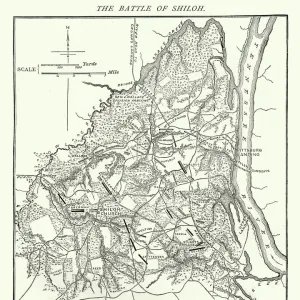
Battles near Metz, Franco-Prussian War in 1870

![]()
Wall Art and Photo Gifts from Fine Art Storehouse
Battles near Metz, Franco-Prussian War in 1870
Illustration of a Battles near Metz, Franco-Prussian War in 1870
Unleash your creativity and transform your space into a visual masterpiece!
Nastasic
Media ID 19681629
FEATURES IN THESE COLLECTIONS
> Fine Art Storehouse
> History
> Battles & Wars
> Historcal Battle Maps and Plans
> Fine Art Storehouse
> Map
> Historical Maps
> Maps and Charts
> Early Maps
EDITORS COMMENTS
This print titled "Battles near Metz, Franco-Prussian War in 1870" takes us back to a significant moment in history. The image portrays the intensity and chaos that engulfed the battlefield during this infamous conflict. With meticulous attention to detail, Nastasic's illustration transports us to the heart of the action. The composition is filled with smoke billowing from cannons and muskets, creating an atmosphere of tension and uncertainty. Soldiers clad in their uniforms can be seen engaged in fierce combat, displaying both bravery and fear on their faces. The artist masterfully captures the desperation etched into each soldier's expression as they fight for their respective nations. Through this artwork, we are reminded of the devastating consequences of war - lives lost, cities destroyed, and families torn apart. It serves as a poignant reminder of our collective history and encourages reflection on how conflicts shape societies. Nastasic's skillful use of light and shadow adds depth to this scene while highlighting individual moments amidst the chaos. The attention given to intricate details such as weaponry and uniforms further enhances its historical accuracy. This print from Fine Art Storehouse not only showcases Nastasic's talent but also invites viewers to delve deeper into one of Europe's most significant wars. It serves as a powerful visual representation that allows us to connect with those who fought bravely during these battles near Metz in 1870
MADE IN THE USA
Safe Shipping with 30 Day Money Back Guarantee
FREE PERSONALISATION*
We are proud to offer a range of customisation features including Personalised Captions, Color Filters and Picture Zoom Tools
SECURE PAYMENTS
We happily accept a wide range of payment options so you can pay for the things you need in the way that is most convenient for you
* Options may vary by product and licensing agreement. Zoomed Pictures can be adjusted in the Cart.