Home > Maps and Charts > Related Images
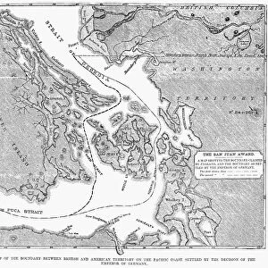
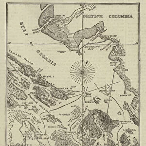
Photo Mug : Antique Map of the San Juan Islands - 19th Century


![]()
Home Decor from Fine Art Storehouse
Antique Map of the San Juan Islands - 19th Century
Vintage map of the San Juan Islands. The area has been disputed since the 1850s, in the 21st century the area was finally recognized as the Salish Sea. Vintage etching circa late 19th century
Unleash your creativity and transform your space into a visual masterpiece!
powerofforever
Media ID 15149721
© This content is subject to copyright
Photo Mug (11 oz)
"Add a touch of history to your daily routine with our Media Storehouse Antique Map of the San Juan Islands Photo Mug. This vintage mug features an intricately detailed etching of a 19th century map of the San Juan Islands, showcasing the disputed area that was later recognized as the Salish Sea in the 21st century. Perfect for tea or coffee, this collectible mug is not only functional but also a beautiful conversation starter. Bring a piece of the past into your present with the Media Storehouse Antique Map of the San Juan Islands Photo Mug."
A personalized photo mug blends sentimentality with functionality, making an ideal gift for cherished loved ones, close friends, or valued colleagues. Preview may show both sides of the same mug.
Elevate your coffee or tea experience with our premium white ceramic mug. Its wide, comfortable handle makes drinking easy, and you can rely on it to be both microwave and dishwasher safe. Sold in single units, preview may show both sides of the same mug so you can see how the picture wraps around.
Mug Size is 8cm high x 9.5cm diameter (3.1" x 3.7")
These are individually made so all sizes are approximate
FEATURES IN THESE COLLECTIONS
> Fine Art Storehouse
> Map
> Historical Maps
> Maps and Charts
> Related Images
EDITORS COMMENTS
This antique map of the San Juan Islands takes us back to the 19th century, offering a glimpse into a time when this picturesque archipelago was at the center of territorial disputes. The intricate details and delicate etching transport us to an era where cartography was both art and science. Since the 1850s, these islands have been subject to intense debate over their rightful ownership. However, in a significant development of the 21st century, this area finally gained recognition as part of the Salish Sea – a name that pays homage to its indigenous roots and cultural significance. This vintage print serves as a reminder of how history can shape our understanding and perception of geographical boundaries. The artist's skillful rendering captures not only the physical features but also evokes a sense of wonder about what lies beyond those shores. Each contour line tells stories untold, inviting exploration and igniting curiosity about past voyages embarked upon by brave sailors navigating these treacherous waters. As we admire this exquisite piece from Fine Art Storehouse, let us appreciate not only its aesthetic value but also acknowledge how it symbolizes resilience, diplomacy, and ultimately unity in recognizing shared heritage. It stands as a testament to human progress in resolving conflicts through dialogue rather than force. Incorporating this antique map into your collection is more than just acquiring artwork; it is embracing history itself – an opportunity to connect with generations past while celebrating our collective journey towards peace and understanding.
MADE IN THE USA
Safe Shipping with 30 Day Money Back Guarantee
FREE PERSONALISATION*
We are proud to offer a range of customisation features including Personalised Captions, Color Filters and Picture Zoom Tools
SECURE PAYMENTS
We happily accept a wide range of payment options so you can pay for the things you need in the way that is most convenient for you
* Options may vary by product and licensing agreement. Zoomed Pictures can be adjusted in the Cart.