Home > North America > Canada > Maps
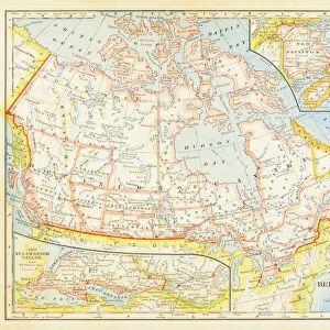
Antique map of Canada, 1884, 19th Century

![]()
Wall Art and Photo Gifts from Fine Art Storehouse
Antique map of Canada, 1884, 19th Century
Vintage engraving of Antique map of Canada, 1884, 19th Century
Unleash your creativity and transform your space into a visual masterpiece!
duncan1890
Media ID 18563432
FEATURES IN THESE COLLECTIONS
> Fine Art Storehouse
> Map
> Historical Maps
> Maps and Charts
> Early Maps
> North America
> Canada
> Maps
EDITORS COMMENTS
This print showcases an exquisite antique map of Canada, dating back to the year 1884. A true treasure from the 19th century, this vintage engraving offers a glimpse into the rich history and cartography of our northern neighbor. The intricate details and expert craftsmanship evident in this piece truly transport us back in time. The map itself is a testament to the artistry and precision that went into creating such historical documents. Every contour, river, and border has been meticulously etched onto paper using traditional engraving techniques. It serves as a reminder of how maps were once carefully crafted by skilled hands before the advent of modern technology. As we gaze upon this remarkable artifact, we can't help but marvel at its significance within Canadian history. It provides valuable insights into the geographical landscape during that era while also offering glimpses into cultural influences and territorial boundaries. Duncan1890's photograph captures not only the beauty of this antique map but also its inherent value as a piece of historical documentation. Through his lens, he preserves both its visual appeal and its importance as an educational resource for future generations. Whether you are a lover of history or simply appreciate fine art, this stunning print will undoubtedly captivate your imagination with its timeless charm
MADE IN THE USA
Safe Shipping with 30 Day Money Back Guarantee
FREE PERSONALISATION*
We are proud to offer a range of customisation features including Personalised Captions, Color Filters and Picture Zoom Tools
SECURE PAYMENTS
We happily accept a wide range of payment options so you can pay for the things you need in the way that is most convenient for you
* Options may vary by product and licensing agreement. Zoomed Pictures can be adjusted in the Cart.