Home > North America > United States of America > Indiana > Indianapolis
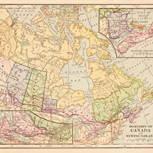
Map of Canada 1889

![]()
Wall Art and Photo Gifts from Fine Art Storehouse
Map of Canada 1889
Indiana Educational Series The Complete Geography - Indianapolis 1889
Unleash your creativity and transform your space into a visual masterpiece!
THEPALMER
Media ID 14756304
© This content is subject to copyright
British Columbia Canada North America Ontario Quebec United States Manitoba
FEATURES IN THESE COLLECTIONS
> Fine Art Storehouse
> Map
> Historical Maps
> Fine Art Storehouse
> Map
> USA Maps
> Maps and Charts
> Early Maps
> North America
> Canada
> Maps
> North America
> United States of America
> Indiana
> Indianapolis
> North America
> United States of America
> Maps
Map of Canada 1889 - A Glimpse into North America's Historical Tapestry
EDITORS COMMENTS
. This print showcases a vintage treasure, the "Map of Canada 1889" from the renowned Indiana Educational Series The Complete Geography. Transporting us back to Indianapolis in 1889, this piece offers a fascinating glimpse into the intricate cartographic details that shaped our understanding of North America at that time. The map spans across vast territories, capturing the diverse landscapes and political boundaries of both the United States and Canada. From British Columbia to Ontario, Quebec to Manitoba, it traces each province's borders with remarkable precision. This visual masterpiece not only serves as an educational tool but also stands as a testament to human curiosity and exploration. As we delve deeper into this historical tapestry, we are reminded of how far we have come since then. The Map of Canada 1889 invites us to reflect on the ever-evolving nature of our world—how nations have grown and transformed over time. Expertly curated by THEPALMER for Fine Art Storehouse, this print preserves not just a geographical representation but also captures an era when maps were meticulously hand-drawn works of art. It reminds us that even in today's digital age, there is still immense value in appreciating these tangible pieces that connect us with our past. Whether displayed in classrooms or homes alike, this stunning artwork sparks conversations about history and geography while adding a touch of nostalgia to any space.
MADE IN THE USA
Safe Shipping with 30 Day Money Back Guarantee
FREE PERSONALISATION*
We are proud to offer a range of customisation features including Personalised Captions, Color Filters and Picture Zoom Tools
SECURE PAYMENTS
We happily accept a wide range of payment options so you can pay for the things you need in the way that is most convenient for you
* Options may vary by product and licensing agreement. Zoomed Pictures can be adjusted in the Cart.